Lake Martin EF4
Member
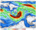
Started this as although the SPC has "PREDICTABILITY TOO LOW" the Euro is showing what seems to be a very intense bout of severe weather on this date.
Follow along with the video below to see how to install our site as a web app on your home screen.
Note: This feature may not be available in some browsers.
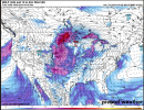
...Days 7-8/Mon-Tue...
Severe potential could once again increase early next week across
parts of the Arklatex into the Mid/Lower MS and TN Valley vicinity.
Another large-scale upper trough is expected to develop eastward
across the western U.S. on Monday before moving into the central
U.S. on Tuesday. However, guidance is vastly different in the timing
of this system and how far north or south the trough will be
located. While severe potential will likely accompany this system
and probabilities will likely be needed in later outlooks,
confidence in where the greatest threat will occur is low at this
time.
.png")

Hoo boy.

12z GEFS is pretty incredible for this timeframe. There is a very high ceiling on this period if we get troughs ejecting coherently.
where is ole Fred? I haven't seen him around here in quite a whileAppreciate having Andy's input more often here and on American WX but am officially putting up the @Fred Gossage bat signal.
They have been busy getting ready moved to the new studios for Tennessee Valley Weather.where is ole Fred? I haven't seen him around here in quite a while

This is really impressive this far outThis
This is really impressive this far outThis

let the drinking beginThe new EURO has a less favorable trough ejection.
The consistency is not there yet for the more favorable ejection. However, should it occur there does not appear to be a shortage of impressive instability.
@Richardjacks as wellAppreciate having Andy's input more often here and on American WX but am officially putting up the @Fred Gossage bat signal.