So I have the look at Friday in now. I'll probably run a new model later, but here's the take from my model on Friday's threat. Remember it's 2km resolution, so it has 125% more grid cells than the HRRR.
The threat looks minimal (if my model verifies) until around 5 PM CDT. The threat algorithm isn't picking up much, but the supercells popping off look gnarly.
View attachment 38941
Okay, here we go *sadface* By 6 PM, those supercells from the 5 PM frame are tornadic quite possibly, with some very extreme parameters involved.
View attachment 38942
At 7 PM, that same cell that was High at 6 PM is High again, and all hell is breaking lose officially. That cell is explicitly being forecast to be high-end tornadic, with UH approaching 600.
View attachment 38943
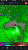
At 8 PM. Geez, do I even need to say anything? Arkansas is getting demolished.
View attachment 38944
Thankfully, after 9PM or so, it dies down very quickly overnight. But for a few hours, it's very intense. I'd say North-Central and North-East Arkansas needs to prepare for a major situation tomorrow evening. Let's see what the 0z models, including the HRRR have to say.