cincywx
Member
gonna pass south of greensburg on its current track
Follow along with the video below to see how to install our site as a web app on your home screen.
Note: This feature may not be available in some browsers.
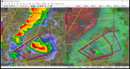
I have little doubt that's a tornado on the ground. Very tight velocity couplet. DDC really needs to issue a tornado warning.


The storm near Fairview, OK is getting a stronger meso.
293
WFUS54 KOUN 022030
TOROUN
OKC003-093-022115-
/O.NEW.KOUN.TO.W.0019.220502T2030Z-220502T2115Z/
BULLETIN - EAS ACTIVATION REQUESTED
Tornado Warning
National Weather Service Norman OK
330 PM CDT Mon May 2 2022
The National Weather Service in Norman has issued a
* Tornado Warning for...
South central Alfalfa County in northwestern Oklahoma...
Major County in northwestern Oklahoma...
* Until 415 PM CDT.
* At 329 PM CDT, a severe thunderstorm capable of producing a
tornado was located 6 miles northeast of Orion, moving east at 35
mph. A funnel cloud has been reported 10 miles west of Fairview.
HAZARD...Tornado and golf ball size hail.
SOURCE...Radar indicated rotation.
IMPACT...Flying debris will be dangerous to those caught without
shelter. Mobile homes will be damaged or destroyed.
Damage to roofs, windows, and vehicles will occur. Tree
damage is likely.
* Locations impacted include...
Fairview, Ringwood, Cleo Springs, Ames, Meno, Orienta, Isabella and
Orion.
PRECAUTIONARY/PREPAREDNESS ACTIONS...
TAKE COVER NOW! Move to a storm shelter, safe room or an interior
room on the lowest floor of a sturdy building. Avoid windows. If you
are outdoors, in a mobile home, or in a vehicle, move to the closest
substantial shelter and protect yourself from flying debris.
&&
LAT...LON 3620 9813 3617 9877 3634 9883 3640 9864
3639 9859 3640 9857 3640 9854 3643 9853
3653 9819
TIME...MOT...LOC 2029Z 255DEG 30KT 3628 9869
TORNADO...RADAR INDICATED
MAX HAIL SIZE...1.75 IN
$$
Ware
It's clearly just the radar picking up echoes from a wind farmCounterpoint: "No..."

347
WFUS53 KDDC 022043
TORDDC
KSC007-097-151-022115-
/O.NEW.KDDC.TO.W.0002.220502T2043Z-220502T2115Z/
BULLETIN - EAS ACTIVATION REQUESTED
Tornado Warning
National Weather Service Dodge City KS
343 PM CDT Mon May 2 2022
The National Weather Service in Dodge City has issued a
* Tornado Warning for...
Southeastern Kiowa County in south central Kansas...
Northwestern Barber County in south central Kansas...
Southwestern Pratt County in south central Kansas...
* Until 415 PM CDT.
* At 343 PM CDT, a severe thunderstorm capable of producing a tornado
was located near Belvidere, moving east at 35 mph.
HAZARD...Tornado and quarter size hail.
SOURCE...Radar indicated rotation.
IMPACT...Flying debris will be dangerous to those caught without
shelter. Mobile homes will be damaged or destroyed.
Damage to roofs, windows, and vehicles will occur. Tree
damage is likely.
* This dangerous storm will be near...
Belvidere around 355 PM CDT.
Croft around 400 PM CDT.
Other locations in the path of this tornadic thunderstorm include Sun
City.
PRECAUTIONARY/PREPAREDNESS ACTIONS...
TAKE COVER NOW! Move to a basement or an interior room on the lowest
floor of a sturdy building. Avoid windows. If you are outdoors, in a
mobile home, or in a vehicle, move to the closest substantial shelter
and protect yourself from flying debris.
&&
LAT...LON 3735 9900 3738 9900 3738 9910 3744 9925
3754 9923 3756 9887 3732 9893
TIME...MOT...LOC 2043Z 277DEG 29KT 3747 9917
TORNADO...RADAR INDICATED
MAX HAIL SIZE...1.00 IN
$$
SPRINGER