
Navigation
Install the app
How to install the app on iOS
Follow along with the video below to see how to install our site as a web app on your home screen.
Note: This feature may not be available in some browsers.
More options
-
Welcome to TalkWeather! We see you lurking around TalkWeather! Take the extra step and join us today to view attachments, see less ads and maybe even join the discussion. CLICK TO JOIN TALKWEATHER
You are using an out of date browser. It may not display this or other websites correctly.
You should upgrade or use an alternative browser.
You should upgrade or use an alternative browser.
Severe WX April 19-22nd, 2023
- Thread starter Lake Martin EF4
- Start date
WhirlingWx
Member
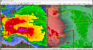
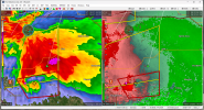
Obviously you can still have tornadoes when the rest of the rain is right in front of the mesocyclone, but I think this cell is starting to get a more classic look again, with the core of the rain shifting more to the north and out from the front of the circulation's path. I don't know the proper meteorological terms for it (am I thinking of the FFD? I don't know), but I hope what I'm saying makes some sense, lolLooks like another attempt coming north of Slaughterville. Hard to see much on velocity but the reflectivity structure looks much "cleaner" all of a sudden.
TornadoFan
Member
TornadoFan
Member
The Slaughterville storm looks really suspicious again.
CheeselandSkies
Member
TornadoFan
Member
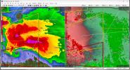
It's wrapping up again.
CheeselandSkies
Member
WhirlingWx
Member
Possibly another big one coming W of Etowah, OK...
WhirlingWx
Member
Spotter report 4 miles east of Slaughterville for a large tornado with power flashes
TornadoFan
Member
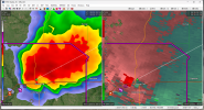
Looks like it could be a wedge.
Muwx
Member
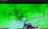
Might have twins in Kansas
WhirlingWx
Member
So much lightning on the stream, difficult to fully discern the tornado's structure but clearly an intense storm.
WhirlingWx
Member
Good catch. Two circulationsMight have twins in Kansas
Attachments
TornadoFan
Member
Sidney, IA
Muwx
Member
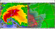
Debris ball in Oklahoma? Hard to tell on CC but reflectively looks suspect.
Equus
Member
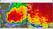
Debris ball just exploded w the tornado at Etowah

CheeselandSkies
Member
TornadoFan
Member
Debris ball on reflectivity.