Evan
Member
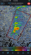
Nasty TOR warned storm in the Nooga suburbs.
Follow along with the video below to see how to install our site as a web app on your home screen.
Note: This feature may not be available in some browsers.
Those don’t seem to be rotating.Are those supercells firing off west and south west of Montgomery? That might be bad news because that area is pretty much untapped.
Tornado on the ground in East Brainerd, TN! This is a very populated area unfortunately.
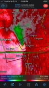
Big time. This thing is doing significant damage in the Chattanooga suburbs.TDS near East Brainerd.

BMX just issued a tornado warning for Cherokee Co.Saw that. No warning on it, but also no TDS. I don’t think anything touched down.
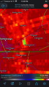
what was the GTG shear on the storm?
Also watch this area south of Fort Payne. Broad but intense. Will be trouble if it tightens up. This same area has been hammered multiple times today.
View attachment 2870
I saw 160mph with L3 data. That was co-located directly over the Ponderosa Pines mobile home park so gonna have to hope that there was some tilt with the storm there.