• Welcome to TalkWeather!
    We see you lurking around TalkWeather! Take the extra step and join us today to view attachments, see less ads and maybe even join the discussion.
    CLICK TO JOIN TALKWEATHER
  • April 2024 Weather Video of the Month
    Post your nominations now!

Severe WX April 11th-13th, 2020 Severe Weather Threat

Equus

Member
Messages
3,346
Reaction score
3,532
Location
Jasper, AL
Special Affiliations
  1. SKYWARN® Volunteer
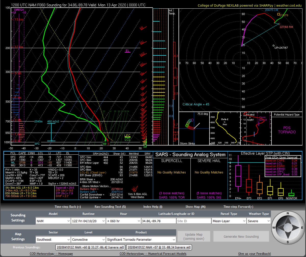
Instability trends are certainly scary. Can't see any mitigating factor that doesn't still hit someone somewhere with a strong tornado...

I know people keep wanting to throw in 4/27 comparisons (as will happen for the next 30 years) but honestly it does remind me of the mesoscale setup, morning convection perhaps setting up a volatile boundary-laden corridor for warm sector cells to go nuts on way too close to home; hopefully that won't pan out but absolutely can't be ruled out
 
Last edited:

warneagle

Member
Messages
4,018
Reaction score
3,993
Location
Arlington, VA
Special Affiliations
  1. SKYWARN® Volunteer
As if the severe wasn't enough, there's also a Day 3 moderate risk of excessive rainfall...

99ewbg.gif
 

Weatherphreak

Member
Messages
352
Reaction score
346
Location
Huntsville
I watched Brandon Spinner's stream from WAFF this morning and he was showing all the different ingredients going into this system. The Euro had the CAPE struggling to get above 200 in most of North Alabama. The GFS was a little better but had the best CAPE with what I'd imagine would the squall line around midnight. Everything else looked to be in place.
 

Kory

Member
Messages
4,928
Reaction score
2,119
Location
Tuscaloosa, Alabama
I watched Brandon Spinner's stream from WAFF this morning and he was showing all the different ingredients going into this system. The Euro had the CAPE struggling to get above 200 in most of North Alabama. The GFS was a little better but had the best CAPE with what I'd imagine would the squall line around midnight. Everything else looked to be in place.
And he’s incorrect in saying that.
 

bwalk

Member
Messages
597
Reaction score
291
Location
Prattville, Al
This is the NAM STP for 10pm Sunday night. (info is a couple of runs old). This is an in-the-dark nighttime disaster for central to N. Alabama if it were to verify.

1586539693836.png
 

xJownage

Member
Messages
570
Reaction score
604
Location
Jacksonville, Florida
Multiple supercells in the warm sector, but I'm seeing some red flags that the squall that's supposed to come in behind the first wave might be just as dangerous.

90e89743903b729db4295eb8201b9d45-png.jpg


This sounding is from N MS at 00z, behind the first wave of supercells and in front of the predicted squall. The shear looks more than good enough to support at least semi-discrete supercells coming out of the line, and this sounding is even more explosive than some of the ones in E MS/W AL. Is anybody else seeing the potential for two rounds of tornadic supercells with this system?
 

Taylor Campbell

Moderator
Moderator
PerryW Project Supporter
Messages
2,141
Reaction score
2,253
Location
Wedowee, AL
Special Affiliations
  1. SKYWARN® Volunteer
Multiple supercells in the warm sector, but I'm seeing some red flags that the squall that's supposed to come in behind the first wave might be just as dangerous.

This sounding is from N MS at 00z, behind the first wave of supercells and in front of the predicted squall. The shear looks more than good enough to support at least semi-discrete supercells coming out of the line, and this sounding is even more explosive than some of the ones in E MS/W AL. Is anybody else seeing the potential for two rounds of tornadic supercells with this system?

Yes, absolutely.
 

Richardjacks

Member
Meteorologist
Messages
1,161
Reaction score
1,331
Location
Atop Red Mountain Birmingham, Al
Finally got a look at the 12z cams, that round near bham around 3pm looks just crazy
Yes, absolutely.
Yes, that is what is so concerning to me, there is more than one opportunity for this system to reach its full potential. I could see some areas with likely more than one, and possibly even more than two threats...and all of those look equally dangerous.
 

xJownage

Member
Messages
570
Reaction score
604
Location
Jacksonville, Florida
Yeah, the heavy STP that far north is really scary if discrete supercells are the mode in that area. I have a very close friend who lives with her family in the Nashville area and I would hate to see a repeat.
 

Brice

Member
Messages
353
Reaction score
227
Location
Lynchburg, Virginia
Each time I look at the SPC outlook I gain more confidence of a High Risk area, by the time day one comes around there might be a 45% chance of a tornado within a 25 mile radius, that's concerning
 

Austin Dawg

Member
Sustaining Member
Messages
900
Reaction score
1,394
Location
Leander, Texas
Looks like the highest values of the STP engulf most of Northwest Ms before moving East on the 18z. :oops:

I hope that this is not the case too many people I love are in this are. I have already been texting them today to make plans for this. Last time everyone was at work. I am really afraid what might happen if any tornadoes hit a town directly in Mississippi or Alabama since everyone will be at home.
 

JayF

Technical Administrator
Staff member
Administrator
Moderator
Technical Admin
Sustaining Member
Messages
1,626
Reaction score
883
Location
Hartselle, al
HAM Callsign
KB4JCS
I hope that this is not the case too many people I love are in this are. I have already been texting them today to make plans for this. Last time everyone was at work. I am really afraid what might happen if any tornadoes hit a town directly in Mississippi or Alabama since everyone will be at home.


Honestly at the time frame of the storms to move through, most people would have been home regardless. But we are going to have to watch this closely and those that have reach make sure people are aware this is coming.
 
Top