REA FORECAST DISCUSSION
NATIONAL WEATHER SERVICE BIRMINGHAM AL
215 PM CDT SUN APR 12 2020
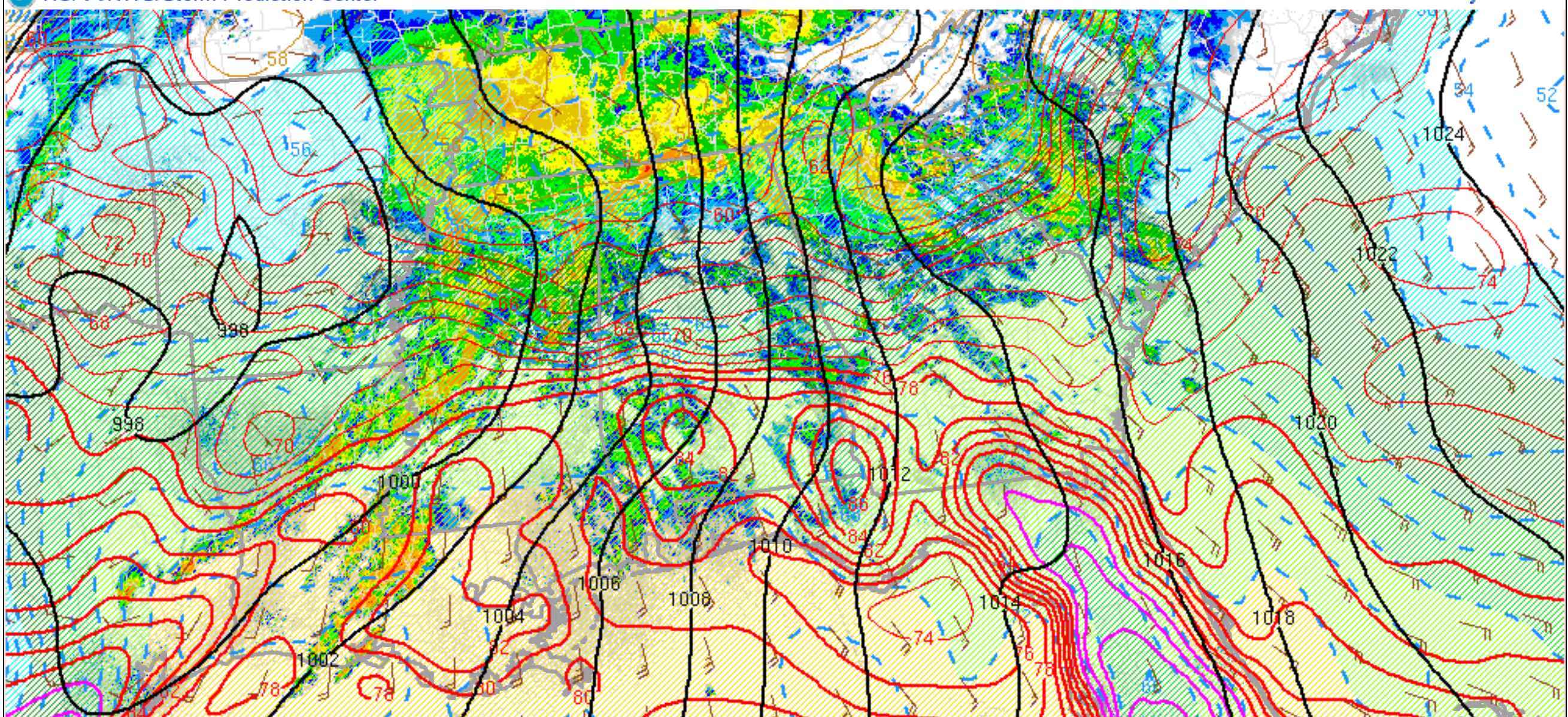
MESOSCALE UPDATE.
THE UPPER LEVEL TROUGH IS CURRENTLY AT A NEUTRAL TILT AND WAS
OVER CENTRAL TEXAS. BROAD FLAT RIDGING WAS PRESENT TO OUR EAST OVER
THE CAROLINAS.
THE PRIMARY SURFACE LOW WAS LOCATED OVER NORTHERN OKLAHOMA WITH A
COLD FRONT EXTENDING TO THE SOUTH ARCING EASTWARD FROM CENTRAL
OKLAHOMA THROUGH CENTRAL TEXAS. A SECONDARY SURFACE LOW WAS
LOCATED ACROSS EASTERN ARKANSAS.
THE SURFACE WARM FRONT HAS LIFTED NORTH ACROSS MUCH OF THE AREA
WITH STRONG WARM AIR ADVECTION AND POSITIVE MOISTURE ADVECTION
OCCURRING. SURFACE TEMPERATURES ARE NOW IN THE LOW 80S SOUTH WITH
DEW POINTS AROUND 70.
THE LOW-LEVEL JET CONTINUES TO INTENSIFY WITH 50 KT WINDS NOW AS
LOW AS 925 MB PER THE 18Z SOUNDING. THE DYNAMICS REMAIN FAVORABLE
WITH BULK SHEAR VALUES MEASURED JUST OVER 60 KTS AND 0-1 KM
STORM-RELATIVE HELICITY VALUES COMPUTED REMAINING AROUND 400
M2/S2.
THERMODYNAMICALLY, SURFACE DESTABILIZATION IS UNDERWAY FROM SOUTH
TO NORTH. CONVECTION HAS BEEN MORE SPARCE NOW THAT THE ELEVATED
MIXED LAYER (EML) HAS STREAMED INTO THE AREA ALOFT. THIS IS
ALLOWING SURFACE-BASED INSTABILITY VALUES TO INCREASE. THIS WARM
AND DRY LAYER WILL HELP ACT AS A CAP TO LIMIT CONVECTIVE
DEVELOPMENT AND ALLOW FOR INSTABILITY TO BUILD THROUGH TIME.
THE RISK FOR TORNADOES, INCLUDING STRONG LONG-TRACK TORNADOES,
WILL INCREASE THROUGH THE AFTERNOON AND INTO THE EVENING HOURS AS
SUPERCELLS MAY DEVELOP AS THE CAP ERODES WITH TIME AS HEIGHTS FALL
WITH THE APPROACHING UPPER TROUGH AND AS SHORTWAVES RIPPLE OVER THE
AREA.
LATER THIS EVENING AND TONIGHT THE FORCING ALOFT WILL INCREASE
AND A LINEAR CONVECTIVE BAND IS EXPECTED TO PUSH EAST ACROSS THE
AREA. STRAIGHT-LINE WINDS ALONG WITH EMBEDDED TORNADOES AND THE
RISK FOR HAIL WILL BE PRESENT AS THE LINE OF STORMS MOVES ACROSS
THE AREA.
WE WILL CONTINUE TO PROVIDE MESOSCALE UPDATES AS WE CONTINUE TO
ANALYZE AND GATHER ADDITIONAL OBSERVATIONS AND INFORMATION.