• Welcome to TalkWeather!
    We see you lurking around TalkWeather! Take the extra step and join us today to view attachments, see less ads and maybe even join the discussion.
    CLICK TO JOIN TALKWEATHER

Severe WX April 11th-13th, 2020 Severe Weather Threat

warneagle

Member
Messages
3,730
Reaction score
3,212
Location
Arlington, VA
Special Affiliations
  1. SKYWARN® Volunteer
The forecast soundings on the 06z GFS is just as nasty as the ones Euro and UKMET have been for the last few days. Yikes.
 

Richardjacks

Member
Meteorologist
Messages
1,155
Reaction score
1,308
Location
Atop Red Mountain Birmingham, Al
From what I can tell the Euro is still trending slower --even with last night's run with the trough...if that is right, the GFS still has significant catching up to do. If the Euro is right, the warm sector will likely be further inland than shown...also it is tapping an area that has had a steady stream of deep tropical
moisture from the Pacific.

.trend-ecmwf_full-2020040900-f084.500wh.conus.gif
 
Last edited:
  • Thread starter
  • Moderator
  • #44

Taylor Campbell

Moderator
Moderator
PerryW Project Supporter
Messages
2,102
Reaction score
2,189
Location
Wedowee, AL
Special Affiliations
  1. SKYWARN® Volunteer
The only question I have right now is how far inland the volatile warm sector gets.

That’s always been the question and will remain the question.
 

Kory

Member
Messages
4,928
Reaction score
2,119
Location
Tuscaloosa, Alabama
From what I can tell the Euro is still trending slower --even with last night's run with the trough...if that is right, the GFS still has significant catching up to do. If the Euro is right, the warm sector will likely be further inland than shown...also it is tapping an area that has had a steady stream of deep tropical moisture from the Pacific.
UKMET does show an ongoing complex of storms over north Alabama similar to a 4/15/2011 set up...stunting the northward progression of the unstable air past I-20/59.
 

Kory

Member
Messages
4,928
Reaction score
2,119
Location
Tuscaloosa, Alabama
We have to remember that face value surface temps are likely 3-5 degrees too cool. That would likely put us in the mid to upper 70s...maybe some isolated 80 degree readings across the warm sector in MS/AL/GA.
 
Messages
452
Reaction score
380
Location
Canton, GA
Can the warm sector make it inland to I-40 in TN on Sunday and north of I-40 in NC or into VA overnight into Monday?
Can it? Sure. However, questions about surface low position and track, potential rainfall ahead of the warm front, and a few other things will ultimately determine the warm sector. Personally, I believe a quality warm sector will push farther north than the GFS shows. Similar to the Euro. Plenty can change though.
 

Kory

Member
Messages
4,928
Reaction score
2,119
Location
Tuscaloosa, Alabama
We are ALREADY having 75% sig tor contours on the SREF...87 hours out. That is certainly rare.
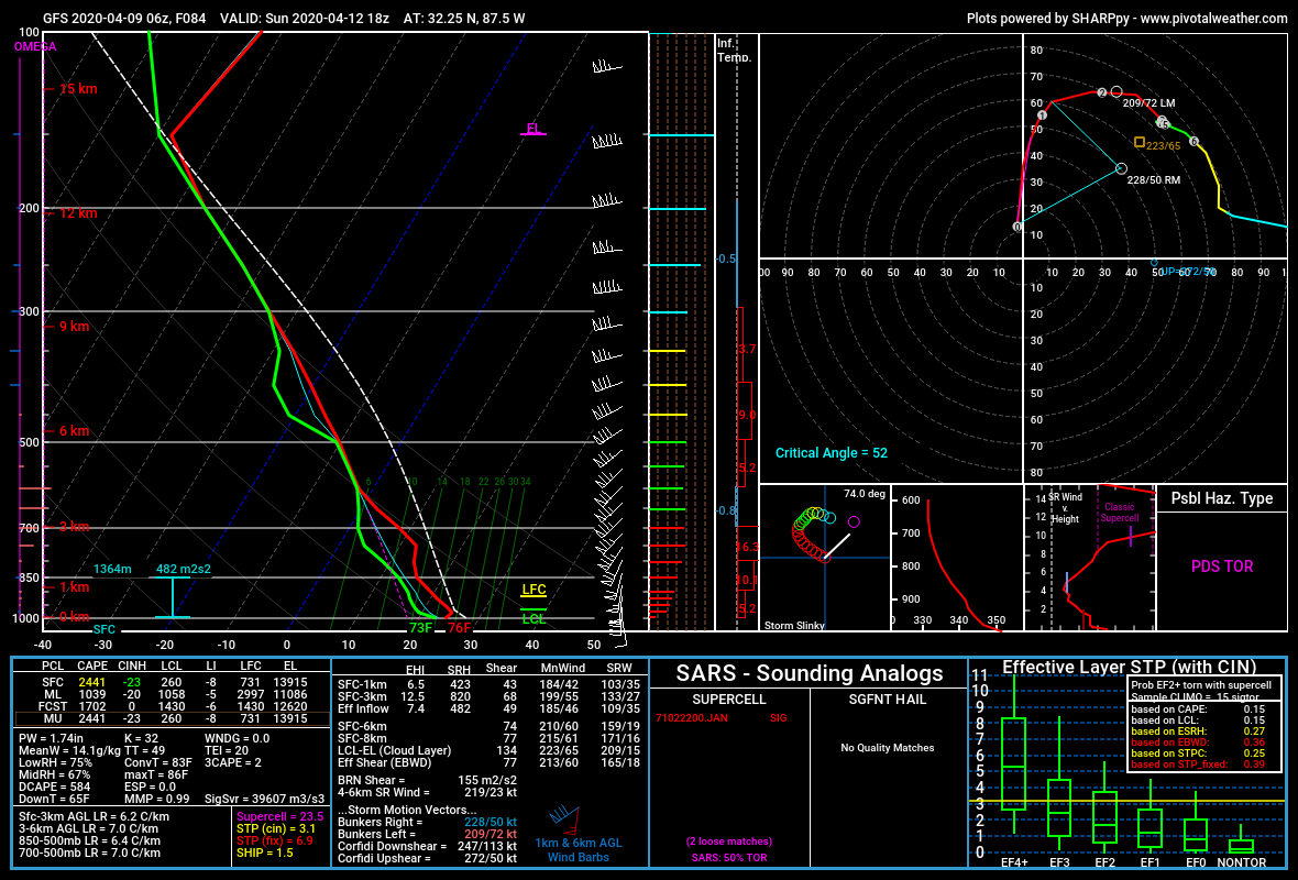
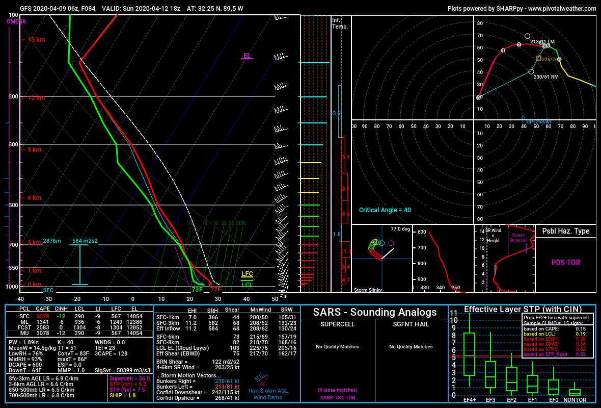
SREF_prob_combined_sigtor__f087.gif
 

Equus

Member
Messages
3,290
Reaction score
3,368
Location
Jasper, AL
Special Affiliations
  1. SKYWARN® Volunteer
6z GFS run, first glance looks dire for S MS/S AL, insane hodos on the simulated soundings

West of Selma
gfs_2020040906_084_32.25-87.5.png

Jackson, MS area
gfs_2020040906_084_32.25-89.5.png
 
Last edited:

Equus

Member
Messages
3,290
Reaction score
3,368
Location
Jasper, AL
Special Affiliations
  1. SKYWARN® Volunteer
12z NAM STP bullseye near Greenwood, MS

nam_2020040912_081_33.55--91.18 (1).png

Aaand near GWX

nam_2020040912_084_33.9--88.56.png
 
Last edited:
Messages
169
Reaction score
304
Location
Gardendale Alabama
Special Affiliations
  1. SKYWARN® Volunteer
  2. ARRL Member
This is becoming very very serious by the day. It might be best that we have a shelter in place order so there won't be people traveling, or caught at an Easter Service during this potential outbreak. We could possible have a High Risk day but won't go that far until we are a little closer in time.
 

Equus

Member
Messages
3,290
Reaction score
3,368
Location
Jasper, AL
Special Affiliations
  1. SKYWARN® Volunteer
If all the trends continue, wonder if we'll get a D3 Moderate. Probably enhanced, but models do seem to be in closer agreement...
 

Gail

Member
Messages
398
Reaction score
579
Location
Caledonia, MS
...and I'm already starting to weigh out bunkering at home with only a hallway or going to the school for the shelter on Sunday. I wouldn't even think twice about it, but I have leukemia and the COVID-19 issues....not a great combination for the day for sure.
 

Kory

Member
Messages
4,928
Reaction score
2,119
Location
Tuscaloosa, Alabama
The NAM simulated reflectivity is showing confluence bands of cellular activity over MS/AL with the dry line hanging back west firing off convection on that over the MS River by Sunday afternoon.
 

bwalk

Member
Messages
597
Reaction score
291
Location
Prattville, Al
6z GFS run, first glance looks dire for S MS/S AL, insane hodos on the simulated soundings

West of Selma
gfs_2020040906_084_32.25-87.5.png

Jackson, MS area
gfs_2020040906_084_32.25-89.5.png

Those sickle hodos make chills run up my spine. Nothing good is ever associated with them. At least the critical angles are not in the 90 degree range as of yet, but still...
 
Last edited:
Back
Top