• Welcome to TalkWeather!
    We see you lurking around TalkWeather! Take the extra step and join us today to view attachments, see less ads and maybe even join the discussion.
    CLICK TO JOIN TALKWEATHER

Severe WX April 11th-13th, 2020 Severe Weather Threat

xJownage

Member
Messages
570
Reaction score
604
Location
Jacksonville, Florida
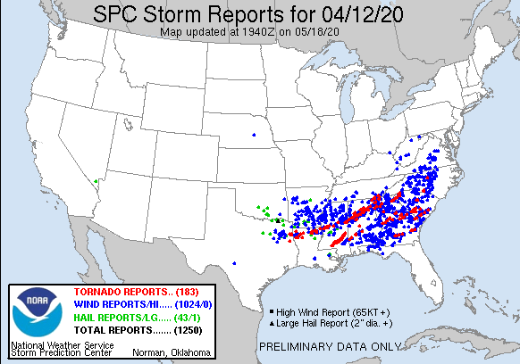
I'm a bit confused about your point here. That QLCS was dropping tornadoes left and right all the way across Alabama. BMX has surveyed 17 tornadoes (so far), and HUN surveyed an additional 6.
We may not have had a swarm of EF4-EF5 tornadoes in Alabama, or a two-mile wide record setting tornado, but Easter Sunday is currently tied with April 28, 2014 for being the fourth largest tornado outbreak in Alabama history (with surveys still ongoing)... and five of those tornadoes were rated as strong. If anyone is saying that the event busted in Alabama or it significantly under-performed, they need to find something else to do with their time other than weather.
Feels like we dodged a bullet in Alabama for the most part. Not to belittle the damaged experienced in some areas, but with our state having been squarely in the bullseye of the moderate risk and considering the devastation from the stronger tornadoes, we were very lucky.
Huh? We just had the fifth largest outbreak of tornadoes in Alabama from the QLCS and embedded super cell structures. Several of them strong...
Thanks to all of you for making it blatantly obvious you didn't read my original post. I was never referring to AL as a whole. Not once. It was ONLY about southern AL. I thought I made that more than clear enough. All due respect Fred, but I'd appreciate if you weren't condescending towards somebody who was presenting QUESTIONS about the event in hopes of gaining a greater understanding of what happened.
And had people looked at more than just the placement of higher instability, they would've expected that ahead of time. Ask Kory about the discussion I had with my team. We talked about forcing and the height field not actually supporting major activity in far south Alabama 72+ hours ahead of time. Everybody was letting CAPE drive their placement when the highest threat area is always where forcing intersects where the best shear and instability combo is located. The 576dm height contour at 500mb is very very often a good southern bound for the greatest threat. There are sometimes exceptions to that, but not often at all. Even when the SPC was drawing their higher risk area near the coast, the 576dm height contour was never expected to get south of around Montgomery.

To the people that looked at everything, this always looked like a central/north type of threat. The only real part that busted about the thing is that north/northwest AL stayed locked in the cool air.
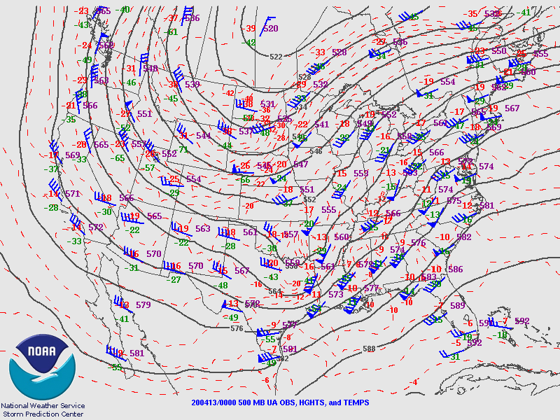
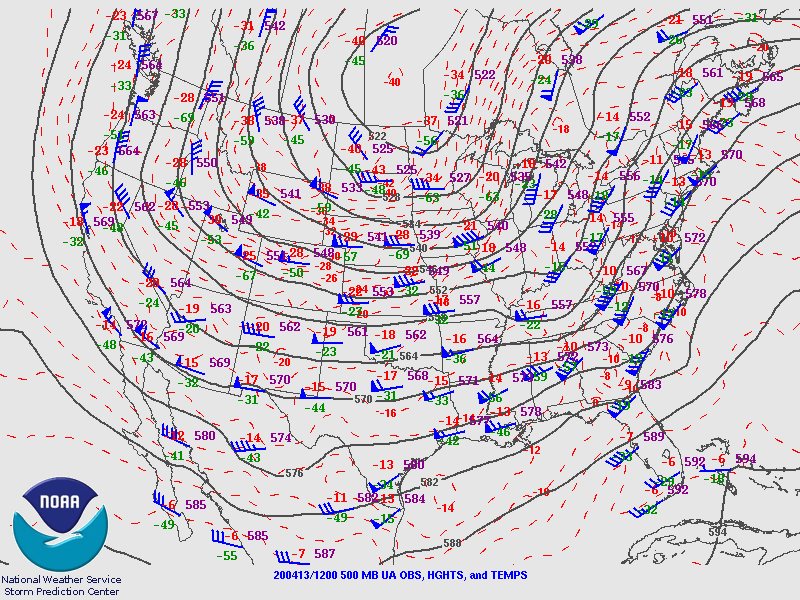
I wasn't discussing this either. If you look at the storm reports, there's a big gap between Southern MS and Southern GA, both of which have a large number of tornado reports. Three violent supercells died on he MS/AL border at almost the exact same location. Several storm clusters in S MS never organized in the first place, but once they got into GA and further east, an organized MCS caused multiple tornadoes. If we want to say that tornado risk is minimized where the height contour becomes the southern bound, doesn't that exclude the Hattiesburg area and Southern GA as well?

Didn't you drop a "this is busting" post on another forum right before everything went haywire on Sunday afternoon?
I don't even use any other forums, the only other weather related media I use is the stormtrack discord. While in the stormtrack discord at the time, I made it abundantly clear that people calling for a bust were being very short-sighted. I didn't even anticipate the greatest threat until around 00Z anyways, as the CAMs had been insistent for days that ALL of AL was going to get hit very hard. The HRRR had been very insistent that elevated convection in LA was going to become surface based as one or two long tracked supercells, and I had been watching the LA cells as a result before they ever went surface based, and watched them organize around McComb, MS. After nailing that part of the forecast the HRRR also insisted those cells would continue through AL until growing upscale later on into a QLCS.
 
Last edited:

Jacob

Member
Messages
1,288
Reaction score
825
Location
Roy, UT
Thanks to all of you for making it blatantly obvious you didn't read my original post. I was never referring to AL as a whole. Not once. It was ONLY about southern AL. I thought I made that more than clear enough. All due respect Fred, but I'd appreciate if you weren't condescending towards somebody who was presenting QUESTIONS about the event in hopes of gaining a greater understanding of what happened.

I see the connection between the two now, but I'd counter with it clearly wasn't that obvious when 4-5 people all missed the supposed connection there.

Anyhow, clearly a case of miscommunication between everybody. I understand the point you were making now.
 

andyhb

Member
Messages
1,087
Reaction score
2,963
Location
Norman, OK
Excuse me for this interruption of "old takes exposed", now back to regularly scheduled programming.
 

Kory

Member
Messages
4,928
Reaction score
2,119
Location
Tuscaloosa, Alabama
The 576dm contour line as Fred pointed out went from South/Central MS into Central AL. That then shifted east, but along and north of that did encompass a lot of the tornado reports (check out the 00z 4/13 synoptic map). You can follow the gray contours of the 576dm height line.

500_200413_00.gif


200412_rpts.gif


Then, shift into 12z 4/13 with the SC tornadoes...what do you know? There's the 576dm line draped just south of the major SC tornadoes!
500_200413_12.gif
 

xJownage

Member
Messages
570
Reaction score
604
Location
Jacksonville, Florida
The 576dm contour line as Fred pointed out went from South/Central MS into Central AL. That then shifted east, but along and north of that did encompass a lot of the tornado reports (check out the 00z 4/13 synoptic map). You can follow the gray contours of the 576dm height line.

500_200413_00.gif


200412_rpts.gif


Then, shift into 12z 4/13 with the SC tornadoes...what do you know? There's the 576dm line draped just south of the major SC tornadoes!
500_200413_12.gif
That would make sense, thanks for the explanation. Was it being pushed into GA behind the QLCS while it was still in AL, explaining the lack of tornadoes in S AL?
 

Kory

Member
Messages
4,928
Reaction score
2,119
Location
Tuscaloosa, Alabama
That would make sense, thanks for the explanation. Was it being pushed into GA behind the QLCS while it was still in AL, explaining the lack of tornadoes in S AL?
I think as you mentioned in your list, the Southern AL anomaly was a factor of several things. Mesolow shot NE after enhancing the Southern MS threat and went onto enhance the threat across North Central AL, SE TN, and NW Georgia while veering surface winds in the Southern portion of the state. Storm mode became a little messy with cell interactions. You can sometimes get that with these negative tilt trough ejections. But the 576dm line seems to be a solid indicator for where the cutoff would be for Dixie events. Fred and I have talked about that extensively (he's still teaching me new things to this day lol).
 

Equus

Member
Messages
3,295
Reaction score
3,380
Location
Jasper, AL
Special Affiliations
  1. SKYWARN® Volunteer
Those subtle factors sure are fascinating. Forecasting is definitely a complicated art
 

xJownage

Member
Messages
570
Reaction score
604
Location
Jacksonville, Florida
I think as you mentioned in your list, the Southern AL anomaly was a factor of several things. Mesolow shot NE after enhancing the Southern MS threat and went onto enhance the threat across North Central AL, SE TN, and NW Georgia while veering surface winds in the Southern portion of the state. Storm mode became a little messy with cell interactions. You can sometimes get that with these negative tilt trough ejections. But the 576dm line seems to be a solid indicator for where the cutoff would be for Dixie events. Fred and I have talked about that extensively (he's still teaching me new things to this day lol).
Are you specifically looking for less than 576dm to forecast the southern contour of a dixie threat? How does this apply to plains threats, or does it have no strong effect on those kinds of setups? In addition, do you trust this data over CAMs and observations the day before and during the events, or is it just another part of how you forecast events like these?
 

buckeye05

Member
Messages
3,160
Reaction score
4,712
Location
Colorado
Ok, so here is a closer look at the house that Andy posted an aerial screenshot of that was completely swept away by the second Bassfield EF4, with little recoverable debris. This photo reveals what I was wondering. This house was well-anchored. Upon seeing this, I can say with a decent degree of certainty that an EF5 rating is necessary and justified at this point. The only thing I can see preventing this, is that I see straight-nailing instead of toe-nailing of the wall studs. However, the 2013 Moore tornado survey established that even straight-nailed homes can be given EF5 ratings given enough contextual support. We'll see what JAN decides...
BassfieldLikelyEF5.jpg
 

andyhb

Member
Messages
1,087
Reaction score
2,963
Location
Norman, OK
Looking like it will settle on high end EF4, winds of 190 mph.
 

warneagle

Member
Messages
3,788
Reaction score
3,381
Location
Arlington, VA
Special Affiliations
  1. SKYWARN® Volunteer
Monroe Co., GA tornado (Forsyth area) rated low-end EF3.

Bibb Co., GA (Macon) rated high-end EF1.
 

Equus

Member
Messages
3,295
Reaction score
3,380
Location
Jasper, AL
Special Affiliations
  1. SKYWARN® Volunteer
If they settle at that, at least it'll be high end EF4; not quite as egregious as Vilonia but still deserving of EF5. Honestly still glad we didn't end up with another high end EF3.

Also the width is truly astonishing. Behind only a few on record
 

WesL

"Bill, I'm talkin' imminent rueage"
Staff member
Administrator
Moderator
Sustaining Member
Messages
3,366
Reaction score
2,648
Location
Fayetteville, AR
Special Affiliations
  1. SKYWARN® Volunteer
Afternoon all. I've removed some of the personal stuff from the thread this afternoon. I understand that many of you are not pleased with the opinions and postings of other members concerning this event. Technically no forum rules were broken in this case and no warning points were issued. We strive to let everyone voice their opinion here and sometimes there is a fine line between being free to do that and being disruptive. I would strongly use the block member function if there is someone that gets under your skin. With another possible severe event this weekend, I would really like to not have a repeat of some of the back and forth we had this past weekend and this week. As always if you feel there is content that we need to examine more closely use the report function and we will review it.

If anyone has any issues with the steps I have taken today, reach out to me via PM and we can discuss.
 

Equus

Member
Messages
3,295
Reaction score
3,380
Location
Jasper, AL
Special Affiliations
  1. SKYWARN® Volunteer
Finally a speed estimate on the long track EF3 - 150; kinda thought they might find higher DIs in that long a track but the aerial forest damage imagery paints a much weaker looking path and there apparently weren't fatalities so probably not much high end damage.
 
Logo 468x120
Back
Top