Severe Weather Statement
National Weather Service St Louis MO
335 PM CDT Wed Apr 2 2025
MOC099-187-221-022115-
/O.CON.KLSX.TO.W.0024.000000T0000Z-250402T2115Z/
Jefferson MO-Saint Francois MO-Washington MO-
335 PM CDT Wed Apr 2 2025
...TORNADO WARNING REMAINS IN EFFECT UNTIL 415 PM CDT FOR
SOUTHWESTERN JEFFERSON AND NORTHEASTERN WASHINGTON COUNTIES IN EAST
CENTRAL MISSOURI AND NORTHWESTERN SAINT FRANCOIS COUNTY IN
SOUTHEASTERN MISSOURI...
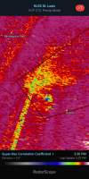
At 335 PM CDT, a confirmed and extremely dangerous tornado was
located near Old Mines, or 6 miles northwest of Potosi, moving
northeast at 50 mph.
This is a PARTICULARLY DANGEROUS SITUATION. TAKE COVER NOW!
HAZARD...Damaging tornado and half dollar size hail.
SOURCE...Emergency management confirmed tornado.
IMPACT...You are in a life-threatening situation. Flying debris
may be deadly to those caught without shelter. Mobile
homes will be destroyed. Considerable damage to homes,
businesses, and vehicles is likely and complete
destruction is possible.
This tornadic storm will remain over mainly rural areas of
Southwestern Jefferson and Northeastern Washington Counties in east
central Missouri and Northwestern Saint Francois County in
southeastern Missouri.
This includes the following State Parks...
Washington State Park.
PRECAUTIONARY/PREPAREDNESS ACTIONS...
Move to an interior room on the lowest floor of a well-built
building away from windows. If you are outdoors, in a mobile home,
or in a vehicle, move to the closest substantial shelter and protect
yourself from flying debris.
&&
LAT...LON 3820 9078 3822 9078 3831 9062 3803 9041
3793 9088 3807 9099 3820 9081
TIME...MOT...LOC 2030Z 241DEG 44KT 3799 9090
TORNADO...OBSERVED
TORNADO DAMAGE THREAT...CONSIDERABLE
MAX HAIL SIZE...1.25 IN