SouthFLwx
Member
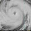
Now probably close to Cat 5 intensityFast…. !
Follow along with the video below to see how to install our site as a web app on your home screen.
Note: This feature may not be available in some browsers.
Now probably close to Cat 5 intensityFast…. !

“STY Bavi is the second Category 5 storm in the Western Pacific (WPAC) basin this year and the first to reach Category 5 in July since STY Maria in 2018. So far this year (through July 3), the basin has recorded its highest number of Category 5 storms since 2015.”Now probably close to Cat 5 intensity

That’s explosive intensification80mph wind increase (80mph to 160mph) within 6:40am Chst (1:40pm CDT Thursday) to 18 UTC (1pm CDT Friday) would be 23 hours.

Yeah, the atmosphere is very much behaving like an El Niño rn.From @ Atlantic as he is on a hiatus from here but am in touch:
“The two Super Typhoons that have formed so far have been strong and there’s no reason to think future storms down the road that may become super typhoons will have any trouble reaching similar intensities. El Niño is likely in full swing already as indicated by the eastern shift in WPAC storm formation, near the IDL. As far as I have seen, El Niño is expected to continue strengthening into the fall and winter, possibly becoming a super El Niño, which would be the first super El Niño since the 2015-16 event.”
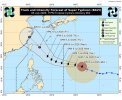
Typhoon Bavi is down to Category 2 strength as it approaches China.
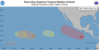
If any of these systems are forming, it's going to be the 40/90 and the system behind it.View attachment 54108
Loads of potential development in the E/CPAC right now. From left to right, 7-day probs are 10%, 40%, 20%, and 90%, respectively.
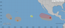
I think the 90 AOI has the highest chance rn of developing into the first hurricane of the seasonView attachment 54127
From left to right, 50/40/10/90/60 for 7 day probs. I'm most interested in the two rightmost systems. I would not be surprised to see an episode of RI take place with the cherry on the right, going to be moving into an area of very favorable shear (≤10 kt deep layer) and fair oceanic heat content (>70 kJ/cm^2) at least in the near term.