
- Thread starter
- #721
Invest 98W is now a high chance JTWC Invest with a TCFA.

WTPN21 PGTW 230900
MSGID/GENADMIN/JOINT TYPHOON WRNCEN PEARL HARBOR HI//
SUBJ/TROPICAL CYCLONE FORMATION ALERT (INVEST 98W)//
RMKS/
1. FORMATION OF A SIGNIFICANT TROPICAL CYCLONE IS POSSIBLE WITHIN
120 NM EITHER SIDE OF A LINE FROM 11.5N 143.5E TO 14.1N 146.7E
WITHIN THE NEXT 12 TO 24 HOURS. AVAILABLE DATA DOES NOT JUSTIFY
ISSUANCE OF NUMBERED TROPICAL CYCLONE WARNINGS AT THIS TIME.
WINDS IN THE AREA ARE ESTIMATED TO BE 18 TO 23 KNOTS. METSAT
IMAGERY AT 230600Z INDICATES THAT A CIRCULATION CENTER IS LOCATED
NEAR 12.9N 145.0E. THE SYSTEM IS MOVING WEST-NORTHWESTWARD AT 33
KNOTS.
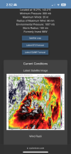
2. REMARKS: THE AREA OF CONVECTION (INVEST 98W) PREVIOUSLY LOCATED
NEAR 11.5N 148.4E IS NOW LOCATED NEAR 12.9N 145.0E, APPROXIMATELY
34 NM SOUTH-SOUTHEAST OF ANDERSEN AFB, GUAM. ANIMATED MULTISPECTRAL
SATELLITE (MSI) IMAGERY DEPICTS A BROAD LOW LEVEL CIRCULATION CENTER
(LLCC) WITH FLARING CONVECTION, AND LOW LEVEL CONVERGENCE FROM THE
SOUTHERN QUADRANT WRAPPING AROUND THE LLCC NEAR GUAM. ENVIRONMENTAL
ANALYSIS REVEALS FAVORABLE CONDITIONS FOR DEVELOPMENT WITH MODERATE VWS
(VERTICAL WIND SHEAR), WARM (30-31 C) SST (SEA SURFACE TEMPERATURE) AND
GOOD EQUATORWARD OUTFLOW ALOFT. GLOBAL MODELS AGREE ON STEADY
DEVELOPMENT AND A NORTHWESTERN TRACK STEERING TOWARDS JAPAN WITHIN A 24-
36 HOUR PERIOD. MAXIMUM SUSTAINED SURFACE WINDS ARE ESTIMATED AT 18 TO
23 KNOTS. MINIMUM SEA LEVEL PRESSURE IS ESTIMATED TO BE NEAR 1007 MB.
THE POTENTIAL FOR THE DEVELOPMENT OF A SIGNIFICANT TROPICAL CYCLONE
WITHIN THE NEXT 24 HOURS IS HIGH.
3. THIS ALERT WILL BE REISSUED, UPGRADED TO WARNING OR CANCELLED BY
240900Z.
//
NNNN
MSGID/GENADMIN/JOINT TYPHOON WRNCEN PEARL HARBOR HI//
SUBJ/TROPICAL CYCLONE FORMATION ALERT (INVEST 98W)//
RMKS/
1. FORMATION OF A SIGNIFICANT TROPICAL CYCLONE IS POSSIBLE WITHIN
120 NM EITHER SIDE OF A LINE FROM 11.5N 143.5E TO 14.1N 146.7E
WITHIN THE NEXT 12 TO 24 HOURS. AVAILABLE DATA DOES NOT JUSTIFY
ISSUANCE OF NUMBERED TROPICAL CYCLONE WARNINGS AT THIS TIME.
WINDS IN THE AREA ARE ESTIMATED TO BE 18 TO 23 KNOTS. METSAT
IMAGERY AT 230600Z INDICATES THAT A CIRCULATION CENTER IS LOCATED
NEAR 12.9N 145.0E. THE SYSTEM IS MOVING WEST-NORTHWESTWARD AT 33
KNOTS.
2. REMARKS: THE AREA OF CONVECTION (INVEST 98W) PREVIOUSLY LOCATED
NEAR 11.5N 148.4E IS NOW LOCATED NEAR 12.9N 145.0E, APPROXIMATELY
34 NM SOUTH-SOUTHEAST OF ANDERSEN AFB, GUAM. ANIMATED MULTISPECTRAL
SATELLITE (MSI) IMAGERY DEPICTS A BROAD LOW LEVEL CIRCULATION CENTER
(LLCC) WITH FLARING CONVECTION, AND LOW LEVEL CONVERGENCE FROM THE
SOUTHERN QUADRANT WRAPPING AROUND THE LLCC NEAR GUAM. ENVIRONMENTAL
ANALYSIS REVEALS FAVORABLE CONDITIONS FOR DEVELOPMENT WITH MODERATE VWS
(VERTICAL WIND SHEAR), WARM (30-31 C) SST (SEA SURFACE TEMPERATURE) AND
GOOD EQUATORWARD OUTFLOW ALOFT. GLOBAL MODELS AGREE ON STEADY
DEVELOPMENT AND A NORTHWESTERN TRACK STEERING TOWARDS JAPAN WITHIN A 24-
36 HOUR PERIOD. MAXIMUM SUSTAINED SURFACE WINDS ARE ESTIMATED AT 18 TO
23 KNOTS. MINIMUM SEA LEVEL PRESSURE IS ESTIMATED TO BE NEAR 1007 MB.
THE POTENTIAL FOR THE DEVELOPMENT OF A SIGNIFICANT TROPICAL CYCLONE
WITHIN THE NEXT 24 HOURS IS HIGH.
3. THIS ALERT WILL BE REISSUED, UPGRADED TO WARNING OR CANCELLED BY
240900Z.
//
NNNN


")
") Though when El Niño happens I just learn to deal with it and turn to the action in the Pacific. Only one El Niño has happened since I started tracking storms: the 2023-24 Strong El Niño event.
Though when El Niño happens I just learn to deal with it and turn to the action in the Pacific. Only one El Niño has happened since I started tracking storms: the 2023-24 Strong El Niño event. so I had a hunch…