
- Thread starter
- #421
Navigation
Install the app
How to install the app on iOS
Follow along with the video below to see how to install our site as a web app on your home screen.
Note: This feature may not be available in some browsers.
More options
-
Welcome to TalkWeather! We see you lurking around TalkWeather! Take the extra step and join us today to view attachments, see less ads and maybe even join the discussion. CLICK TO JOIN TALKWEATHER
You are using an out of date browser. It may not display this or other websites correctly.
You should upgrade or use an alternative browser.
You should upgrade or use an alternative browser.
2025 Global Tropical Cyclone Season Discussion
- Thread starter Atlantic
- Start date
- Thread starter
- #422
It is now May 24th. The Western Pacific has now gone into the top five latest starting seasons on record for the second consecutive year in a row and as it appears that the Western Pacific will not produce a TC within the next 7 days, this streak is favored to continue for at least the next week.
Should we reach May 27th without the first TC not forming, this season will move up to the fourth latest starting season on record.
Should we reach May 27th without the first TC not forming, this season will move up to the fourth latest starting season on record.
- Thread starter
- #423
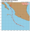
Invest 90E is up in the Eastern Pacific. This is the first Invest in the Western Hemisphere this season so far. 90E is up to 70% in 48 hour or 2 days and 90% in 7 days.
I’m thinking it’s safe to say we will be getting Tropical Depression One-E here within the next 24-48 hours.
I’m thinking it’s safe to say we will be getting Tropical Depression One-E here within the next 24-48 hours.
- Thread starter
- #424
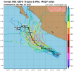
It appears to be getting even closer to a possible tropical depression, an 80/90 shot at development now;Let’s go!

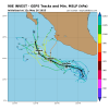
Plus the model guidance in files attached.
Attachments
- Thread starter
- #425
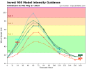
Notice in one of the screenshots that RI25 and RI30 have triggered. That appears to be a small chance at a 25-30 kt increase in intensity in 24ish hours.It appears to be getting even closer to a possible tropical depression, an 80/90 shot at development now;
View attachment 43283
Plus the model guidance in files attached.
- Thread starter
- #426

- Thread starter
- #427

Kds86z
Member
Last edited:
Kds86z
Member
Tropical Storm Alvin tracker: 1st named storm of 2025 season forms off Mexico's coast
Tropical Storm Alvin formed Thursday, just one week after the National Oceanic and Atmospheric Administration predicted an above-average hurricane season this year.
Kds86z
Member

Tropical Storm Alvin Gains Strength
The National Hurricane Center upgraded an area of disturbed weather located off the west coast of Mexico to Tropical Storm Alvin this morning; the storm...
 weatherboy.com
- Thread starter
- #431
- Thread starter
- #432
We have to watch the Eastern Pacific yet again with what is currently a 0/40 AOI that could show up in the coming days.
The Atlantic now should be watched as well, because we have a sloppy signal offshore of the Carolinas, which the GFS recently started to pick up on and a possible CAG-related on-and-off signal by the GFS as well.
The Atlantic now should be watched as well, because we have a sloppy signal offshore of the Carolinas, which the GFS recently started to pick up on and a possible CAG-related on-and-off signal by the GFS as well.
- Thread starter
- #433

Kds86z
Member
This, based off of what I can tell is what’s left of Alvin;
View attachment 43557
The little thing sitting just left of the center of this image. The swirl looking thing.
Rest in piece Alvin…
- Thread starter
- #435
It formed about a month earlier than its 2019 version.Rest in piece Alvin…
Alvin 2019 was Cat 1 that formed on June 25th
- Thread starter
- #437

Kds86z
Member
This is new;
View attachment 43559
You used to only see the Central Pacific only on the Central Pacific area. This here is from the Eastern Pacific area.
Sorry but what’s this mean @Atlantic ?
- Thread starter
- #439
Before (From the tropical weather outlook archives)Sorry but what’s this mean @Atlantic ?

Now;

Notice the difference?
Kds86z
Member
Before (From the tropical weather outlook archives)
View attachment 43560
Now;
View attachment 43561
Notice the difference?
Oh yes I can see where my cousin lives now! lol Hawaii.