
- Thread starter
- #381
Navigation
Install the app
How to install the app on iOS
Follow along with the video below to see how to install our site as a web app on your home screen.
Note: This feature may not be available in some browsers.
More options
-
Welcome to TalkWeather! We see you lurking around TalkWeather! Take the extra step and join us today to view attachments, see less ads and maybe even join the discussion. CLICK TO JOIN TALKWEATHER
You are using an out of date browser. It may not display this or other websites correctly.
You should upgrade or use an alternative browser.
You should upgrade or use an alternative browser.
2025 Global Tropical Cyclone Season Discussion
- Thread starter Atlantic
- Start date
- Thread starter
- #382
And 94P is gone with the wind!
Invest 94P (Tropical Low 34U) is currently located south of the Solomon Islands in the South Pacific Ocean. The system has a LOWchance of developing into a tropical cyclone in the next 24 hours.
What is an Invest?An Invest is an area of disturbed weather that is under investigation for its potential to develop into a tropical cyclone.
The area of convection (Invest 94P / Tropical Low 34U) previously located near 11.2S 156.2E has dissipated and is no longer suspect for the development of a significant tropical cyclone in the next 24 hours.
Information provided by the Joint Typhoon Warning Center (JTWC).
- Thread starter
- #383


- Thread starter
- #384
- Thread starter
- #385
- Thread starter
- #386
- Thread starter
- #387

- Thread starter
- #388
- Thread starter
- #389
Activity by month so far in 2025:
January 2025 - Intense Tropical Cyclone Dikeledi (SWIO) - 115 mph
Tropical Cyclone Pita (SPAC) - 50 mph
Tropical Low 09S (AR) - 35 mph
Severe Tropical Cyclone Sean (AR) - 130 mph
Moderate Tropical Storm Faida (SWIO) - 50 mph
Moderate Tropical Storm Elvis (SWIO) - 50 mph
February 2025 - Very Intense Tropical Cyclone Vince (AR) - 155 mph
Severe Tropical Cyclone Taliah (AR) - 105 mph
Tropical Cyclone 15P (SPAC) - 50 mph
Tropical Cyclone 16P (SPAC) - 45 mph
Severe Tropical Cyclone Zelia (AR) - 150 mph
Severe Tropical Cyclone Alfred (AR) - 130 mph
Tropical Cyclone Rae (SPAC) - 105 mph
Severe Tropical Cyclone Bianca (AR) - 115 mph
Tropical Cyclone Seru (SPAC) - 75 mph
Intense Tropical Cyclone Garance (SWIO) - 120 mph
Tropical Cyclone Honde (SWIO) - 80 mph
Severe Tropical Storm Ivone (SWIO) - 60 mph
Tropical Cyclone Jude (SWIO) - 90 mph
March 2025 - Tropical Cyclone 26S (AR) - 50 mph
Severe Tropical Cyclone Courtney (AR) - 150 mph
Tropical Cyclone Dianne (AR) - 50 mph
April 2025 - Severe Tropical Cyclone Errol (AR) - 160 mph
Tropical Cyclone Tam (SPAC) - 60 mph
Tropical Cyclone 31S (AR) - 40 mph
May 2025 (As of Now) - Tropical Cyclone 32P (AR) - 40 mph
- Thread starter
- #390
Activity by basin and month in 2025:
SWIO = THIS COLOR
AR = THIS COLOR
SPAC = THIS COLOR
SATL = THIS COLOR
NATL = THIS COLOR
EPAC = THIS COLOR
CPAC = THIS COLOR (CPAC combines with the EPAC)
WPAC = THIS COLOR
NIO = THIS COLOR
MED = THIS COLOR
--------------------------------------------------------------------------------------------------------------------------------------------------------------
January 2025 - Intense Tropical Cyclone Dikeledi (SWIO) - 115 mph
Tropical Cyclone Pita (SPAC) - 50 mph
Tropical Low 09S (AR) - 35 mph
Severe Tropical Cyclone Sean (AR) - 130 mph
Moderate Tropical Storm Faida (SWIO) - 50 mph
Moderate Tropical Storm Elvis (SWIO) - 50 mph
February 2025 - Very Intense Tropical Cyclone Vince (AR) - 155 mph
Severe Tropical Cyclone Taliah (AR) - 105 mph
Tropical Cyclone 15P (SPAC) - 50 mph
Tropical Cyclone 16P (SPAC) - 45 mph
Severe Tropical Cyclone Zelia (AR) - 150 mph
Severe Tropical Cyclone Alfred (AR) - 130 mph
Tropical Cyclone Rae (SPAC) - 105 mph
Severe Tropical Cyclone Bianca (AR) - 115 mph
Tropical Cyclone Seru (SPAC) - 75 mph
Intense Tropical Cyclone Garance (SWIO) - 120 mph
Tropical Cyclone Honde (SWIO) - 80 mph
Severe Tropical Storm Ivone (SWIO) - 60 mph
Tropical Cyclone Jude (SWIO) - 90 mph
March 2025 - Tropical Cyclone 26S (AR) - 50 mph
Severe Tropical Cyclone Courtney (AR) - 150 mph
Tropical Cyclone Dianne (AR) - 50 mph
April 2025 - Severe Tropical Cyclone Errol (AR) - 160 mph
Tropical Cyclone Tam (SPAC) - 60 mph
Tropical Cyclone 31S (AR) - 40 mph
May 2025 (As of Now) - Tropical Cyclone 32P (AR) - 40 mph
- Thread starter
- #391
- Thread starter
- #392

- Thread starter
- #393
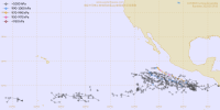
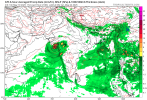
The Eastern Pacific signal is growing for around May 27-31. It is something we should keep an eye on.
We also have the North Indian Ocean to watch as well.
We also have the North Indian Ocean to watch as well.
Attachments
- Thread starter
- #394

- Thread starter
- #395
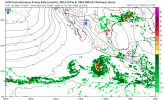
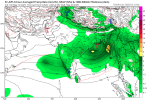
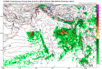
ZCZC MIATWOEP ALLAnd so it begins.... please welcome the first in-season Area of Interest of 2025 everyone!
View attachment 42666
TTAA00 KNHC DDHHMM
Tropical Weather Outlook
NWS National Hurricane Center Miami FL
500 AM PDT Tue May 20 2025
For the eastern North Pacific...east of 140 degrees west longitude:
1. Eastern East Pacific:
An area of low pressure could form by this weekend into early next
week several hundred miles south of the southern coast of Mexico.
Conditions appear favorable for some development of this system
thereafter while it moves westward to west-northwestward at around
10 to 15 mph.
* Formation chance through 48 hours...low...near 0 percent.
* Formation chance through 7 days...low...20 percent.
Forecaster Kelly
- Thread starter
- #396
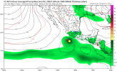
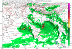
The area of interest in the Arabian Sea has been designated Invest 93A:The Eastern Pacific signal is growing for around May 27-31. It is something we should keep an eye on.
We also have the North Indian Ocean to watch as well.

- Thread starter
- #397
Very aggressive guidience on Invest 93A:The area of interest in the Arabian Sea has been designated Invest 93A:
View attachment 42668

- Thread starter
- #398

- Thread starter
- #399

- Thread starter
- #400