• Welcome to TalkWeather!
    We see you lurking around TalkWeather! Take the extra step and join us today to view attachments, see less ads and maybe even join the discussion.
    CLICK TO JOIN TALKWEATHER

2025 Global Tropical Cyclone Season Discussion

Severe Tropical Cyclone Vince reached a peak of 115 mph overnight before it crossed 90E and moved into Meteo-France\La Reunion's AoR (South-West Indian Ocean) and weakened slightly to 110 mph. Vince was the second major cyclone of the current Australian Region season.

Severe Tropical Cyclone Taliah gained Category 2-eqivelent intensity overnight, with a current intensity of 100 mph.

Moderate Tropical Storm Faida has confounded forecasters at the JTWC as its' center of circulation actually turned southwards near the eastern coast of Madagascar. It is expected to degrade to a remnant low but also has a chance to regenerate in the Mozambique Channel.

Tropical Cyclone 15P is barely holding on and has a current intensity of 40 mph. 15P is expected to transition into a hybrid subtropical system before fully transitioning into a extratropical low and regain some intensity.

Invest 92P (Tropical Low 16U) has been dropped by the BoM of Australia, but has a high chance of forming into a TC with the next 24 hours by the JTWC, which has issued a TCFA on it.
View attachment 33414 View attachment 33415
Severe Tropical Cyclone Taliah is expected to weaken as it moves westwards over Vince's cool wake. Taliah is also expected like Vince already did to cross 90E and move into the South-West Indian Ocean.
 
Intense Tropical Cyclone Vince continues to intensify, and it is currently at 115 kts (130 mph) for now. But Vince is still becoming better defined and it could possibly make a run a high-end Category 4-equivent or even Category 5-equivent status.

Screenshot 2025-02-06 12.29.02 PM.png

Severe Tropical Cyclone Taliah is sitting just barely at Category 1-equivent status at 65 kts (75 mph). Taliah is still expected to regain intensity with the current JTWC forecast cone peaking it at 75 kts (85 mph) at the end of the forecast period.
Screenshot 2025-02-06 12.33.23 PM.png
Note the difference in size between Vince and Taliah. Vince is small and very compact, while Taliah is large and broad-like.


Tropical Cyclone 15P is still alive as a subtropical depression with sustained winds of 30 kts (35 mph)
Screenshot 2025-02-06 12.36.05 PM.png

Invest 92P (Tropical Low 16U in the Australian Region) is now a Subtropical Cyclone with sustained winds of 35 kts (40 mph), the JTWC gives a low chance for 92P to transition into a tropical cyclone.
Screenshot 2025-02-06 12.38.40 PM.png

Invest 92W in the Western Pacific continues to do practically nothing.
Screenshot 2025-02-06 12.40.39 PM.png

And finally, Invest 94S was designated last night, and it is either the remnants of Moderate Tropical Storm Faida or a new circulation that could become a new storm.
Screenshot 2025-02-06 12.43.00 PM.png
 
A comparasion between Very Intense Tropical Cyclone Chido and Intense Tropical Cyclone Vince:

Screenshot 2025-02-06 12.24.48 PM.png
Screenshot 2025-02-06 12.26.44 PM.png

Chido on top, Vince on the bottom.
 
Vince has now intensified to 135 kts (155 mph) and is on the cusp of Cat 5-equivent status.

Tropical Cyclone VINCE

Updated February 06, 2025 at 18:00 UTC

Located at 19.7°S, 80.7°E

Minimum Pressure: 924 mb

Maximum Wind: 135 kt

Radius of Maximum Wind: 12 nm

Environmental Pressure: 1004 mb

Storm Radius: 260 nm

Formerly Invest 99S


Source: https://cyclonicwx.com/storms/
Certainly looks the part. Monster annular buzzsaw there
 
Certainly looks the part. Monster annular buzzsaw there
In pressure, Vince has dethroned Chido for strongest storm. Chido had a pressure of 929 mbs, Vince currently has a pressure of 924 mbs.

I think Vince is likely to intensify a little further to Category 5-equivlent. I'm thinking 140-145 kts (160-165 mph)
 
The new forecast cone for now Very Intense Tropical Cyclone Vince has come out on Zoom Earth:

Screenshot 2025-02-06 3.15.36 PM.pngAs indeed I thought, the JTWC is now expecting Vince to reach 160 mph (140 kts). I am also expecting Vince to reach at least 160 mph.
 
The full forecast for Vince:


WTXS32 PGTW 062100
MSGID/GENADMIN/JOINT TYPHOON WRNCEN PEARL HARBOR HI//
SUBJ/TROPICAL CYCLONE 13S (VINCE) WARNING NR 011//
RMKS/
1. TROPICAL CYCLONE 13S (VINCE) WARNING NR 011
02 ACTIVE TROPICAL CYCLONES IN SOUTHIO
MAX SUSTAINED WINDS BASED ON ONE-MINUTE AVERAGE
WIND RADII VALID OVER OPEN WATER ONLY
---
WARNING POSITION:
061800Z --- NEAR 19.7S 80.7E
MOVEMENT PAST SIX HOURS - 260 DEGREES AT 10 KTS
POSITION ACCURATE TO WITHIN 020 NM
POSITION BASED ON EYE FIXED BY SATELLITE
PRESENT WIND DISTRIBUTION:
MAX SUSTAINED WINDS - 135 KT, GUSTS 165 KT
WIND RADII VALID OVER OPEN WATER ONLY
RADIUS OF 064 KT WINDS - 035 NM NORTHEAST QUADRANT
040 NM SOUTHEAST QUADRANT
040 NM SOUTHWEST QUADRANT
035 NM NORTHWEST QUADRANT
RADIUS OF 050 KT WINDS - 050 NM NORTHEAST QUADRANT
055 NM SOUTHEAST QUADRANT
055 NM SOUTHWEST QUADRANT
050 NM NORTHWEST QUADRANT
RADIUS OF 034 KT WINDS - 075 NM NORTHEAST QUADRANT
095 NM SOUTHEAST QUADRANT
090 NM SOUTHWEST QUADRANT
080 NM NORTHWEST QUADRANT
REPEAT POSIT: 19.7S 80.7E
---
FORECASTS:
12 HRS, VALID AT:
070600Z --- 20.0S 78.5E
MAX SUSTAINED WINDS - 140 KT, GUSTS 170 KT
WIND RADII VALID OVER OPEN WATER ONLY
RADIUS OF 064 KT WINDS - 030 NM NORTHEAST QUADRANT
040 NM SOUTHEAST QUADRANT
040 NM SOUTHWEST QUADRANT
030 NM NORTHWEST QUADRANT
RADIUS OF 050 KT WINDS - 050 NM NORTHEAST QUADRANT
060 NM SOUTHEAST QUADRANT
060 NM SOUTHWEST QUADRANT
050 NM NORTHWEST QUADRANT
RADIUS OF 034 KT WINDS - 080 NM NORTHEAST QUADRANT
100 NM SOUTHEAST QUADRANT
100 NM SOUTHWEST QUADRANT
080 NM NORTHWEST QUADRANT
VECTOR TO 24 HR POSIT: 265 DEG/ 11 KTS
---
24 HRS, VALID AT:
071800Z --- 20.2S 76.2E
MAX SUSTAINED WINDS - 140 KT, GUSTS 170 KT
WIND RADII VALID OVER OPEN WATER ONLY
RADIUS OF 064 KT WINDS - 030 NM NORTHEAST QUADRANT
040 NM SOUTHEAST QUADRANT
040 NM SOUTHWEST QUADRANT
030 NM NORTHWEST QUADRANT
RADIUS OF 050 KT WINDS - 060 NM NORTHEAST QUADRANT
060 NM SOUTHEAST QUADRANT
060 NM SOUTHWEST QUADRANT
060 NM NORTHWEST QUADRANT
RADIUS OF 034 KT WINDS - 080 NM NORTHEAST QUADRANT
110 NM SOUTHEAST QUADRANT
100 NM SOUTHWEST QUADRANT
090 NM NORTHWEST QUADRANT
VECTOR TO 36 HR POSIT: 265 DEG/ 10 KTS
---
36 HRS, VALID AT:
080600Z --- 20.4S 74.0E
MAX SUSTAINED WINDS - 130 KT, GUSTS 160 KT
WIND RADII VALID OVER OPEN WATER ONLY
RADIUS OF 064 KT WINDS - 040 NM NORTHEAST QUADRANT
040 NM SOUTHEAST QUADRANT
040 NM SOUTHWEST QUADRANT
030 NM NORTHWEST QUADRANT
RADIUS OF 050 KT WINDS - 060 NM NORTHEAST QUADRANT
060 NM SOUTHEAST QUADRANT
060 NM SOUTHWEST QUADRANT
060 NM NORTHWEST QUADRANT
RADIUS OF 034 KT WINDS - 090 NM NORTHEAST QUADRANT
110 NM SOUTHEAST QUADRANT
110 NM SOUTHWEST QUADRANT
090 NM NORTHWEST QUADRANT
VECTOR TO 48 HR POSIT: 265 DEG/ 08 KTS
---
EXTENDED OUTLOOK:
48 HRS, VALID AT:
081800Z --- 20.6S 72.3E
MAX SUSTAINED WINDS - 120 KT, GUSTS 145 KT
WIND RADII VALID OVER OPEN WATER ONLY
RADIUS OF 064 KT WINDS - 030 NM NORTHEAST QUADRANT
040 NM SOUTHEAST QUADRANT
040 NM SOUTHWEST QUADRANT
030 NM NORTHWEST QUADRANT
RADIUS OF 050 KT WINDS - 060 NM NORTHEAST QUADRANT
060 NM SOUTHEAST QUADRANT
060 NM SOUTHWEST QUADRANT
060 NM NORTHWEST QUADRANT
RADIUS OF 034 KT WINDS - 090 NM NORTHEAST QUADRANT
110 NM SOUTHEAST QUADRANT
110 NM SOUTHWEST QUADRANT
090 NM NORTHWEST QUADRANT
VECTOR TO 72 HR POSIT: 245 DEG/ 07 KTS
---
72 HRS, VALID AT:
091800Z --- 21.7S 69.7E
MAX SUSTAINED WINDS - 100 KT, GUSTS 125 KT
WIND RADII VALID OVER OPEN WATER ONLY
RADIUS OF 064 KT WINDS - 030 NM NORTHEAST QUADRANT
030 NM SOUTHEAST QUADRANT
030 NM SOUTHWEST QUADRANT
030 NM NORTHWEST QUADRANT
RADIUS OF 050 KT WINDS - 050 NM NORTHEAST QUADRANT
060 NM SOUTHEAST QUADRANT
060 NM SOUTHWEST QUADRANT
050 NM NORTHWEST QUADRANT
RADIUS OF 034 KT WINDS - 080 NM NORTHEAST QUADRANT
110 NM SOUTHEAST QUADRANT
110 NM SOUTHWEST QUADRANT
090 NM NORTHWEST QUADRANT
VECTOR TO 96 HR POSIT: 195 DEG/ 09 KTS
---
LONG RANGE OUTLOOK:
---
96 HRS, VALID AT:
101800Z --- 25.0S 68.6E
MAX SUSTAINED WINDS - 085 KT, GUSTS 105 KT
WIND RADII VALID OVER OPEN WATER ONLY
RADIUS OF 064 KT WINDS - 020 NM NORTHEAST QUADRANT
030 NM SOUTHEAST QUADRANT
030 NM SOUTHWEST QUADRANT
020 NM NORTHWEST QUADRANT
RADIUS OF 050 KT WINDS - 050 NM NORTHEAST QUADRANT
050 NM SOUTHEAST QUADRANT
050 NM SOUTHWEST QUADRANT
050 NM NORTHWEST QUADRANT
RADIUS OF 034 KT WINDS - 080 NM NORTHEAST QUADRANT
110 NM SOUTHEAST QUADRANT
110 NM SOUTHWEST QUADRANT
090 NM NORTHWEST QUADRANT
VECTOR TO 120 HR POSIT: 175 DEG/ 12 KTS
---
120 HRS, VALID AT:
111800Z --- 29.7S 69.3E
MAX SUSTAINED WINDS - 065 KT, GUSTS 080 KT
WIND RADII VALID OVER OPEN WATER ONLY
BECOMING SUBTROPICAL
RADIUS OF 064 KT WINDS - 020 NM NORTHEAST QUADRANT
030 NM SOUTHEAST QUADRANT
030 NM SOUTHWEST QUADRANT
020 NM NORTHWEST QUADRANT
RADIUS OF 050 KT WINDS - 050 NM NORTHEAST QUADRANT
050 NM SOUTHEAST QUADRANT
050 NM SOUTHWEST QUADRANT
050 NM NORTHWEST QUADRANT
RADIUS OF 034 KT WINDS - 080 NM NORTHEAST QUADRANT
110 NM SOUTHEAST QUADRANT
110 NM SOUTHWEST QUADRANT
090 NM NORTHWEST QUADRANT
---
REMARKS:
062100Z POSITION NEAR 19.8S 80.2E.
06FEB25. TROPICAL CYCLONE 13S (VINCE), LOCATED APPROXIMATELY 1319
NM EAST OF PORT LOUIS, MAURITIUS, HAS TRACKED WESTWARD AT 10
KNOTS OVER THE PAST SIX HOURS. MINIMUM CENTRAL PRESSURE AT
061800Z IS 924 MB. MAXIMUM SIGNIFICANT WAVE HEIGHT AT 061800Z
IS 37 FEET. NEXT WARNINGS AT 070900Z AND 072100Z. REFER TO
TROPICAL CYCLONE 14S (TALIAH) WARNINGS (WTXS33 PGTW) FOR
TWELVE-HOURLY UPDATES.//
NNNN
 
The new forecast cone for now Very Intense Tropical Cyclone Vince has come out on Zoom Earth:

View attachment 33443As indeed I thought, the JTWC is now expecting Vince to reach 160 mph (140 kts). I am also expecting Vince to reach at least 160 mph.
Screenshot 2025-02-06 3.23.49 PM.png
 
I apologize for the rapid posting but I have one more thing to post:

Vince has a appeared to have gotten only the slightest bit flattened on its southern side compared to what looks like the peak earlier:

Apparent Peak
Screenshot 2025-02-06 3.31.41 PM.png


Now:
Screenshot 2025-02-06 3.42.37 PM.png

I think the flattening on the south side is may be due to wind shear,
Screenshot 2025-02-06 3.39.43 PM.png
 
Well... I had expected Vince to have weakened overnight, but... Vince seems to have gotten even better looking in appearence!

Yesterday when I posted last:
Screenshot 2025-02-06 3.42.37 PM.png

Vince now:
Screenshot 2025-02-07 8.40.17 AM.png


If Vince doesn't look like a Cat 5 (SSHWS) now, I don't know what it will take to get the JTWC to upgrade it. The JTWC has the current intensity as 130 kts (150 mph). They expect the storm to maintain for a little longer and then recurve southwards and weaken.
 
I'm not sure about making heads or tails on Vince now. It still looks very defined with a 20NM eye according to the JTWC. The convection surrounding the eye has warmed somewhat, though.
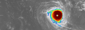
IR Satellite Image
 
The JTWC has kept Vince at 130 kts for 18Z.

In the Australian Region, Taliah has continued to struggle against wind shear but it is expected to reintensify into a mid-end Category 1 (SSHWS with 85 mph winds.
 
Vince is either maintaining intensity or intensifying again, as show by pink colors appearing again; this time in the NW portion of the system:

Screenshot 2025-02-07 3.38.58 PM.png
 
Tropical Cyclone Vince and Tropical Cyclone Taliah are still going, with Vince very likely undergoing extratropical transition as I type this.

Vince was the first Very Intense Tropical Cyclone per Meteo-France since Freddy in 2023.

Both Invests 95P and 96S are now TCs. 95P was designated 16P and 96S was designated 17S but had since been upgraded to Tropical Cyclone Zelia by the Bureau of Meteorology.

Zelia is expected to peak at 95kts according to the JTWC. Zelia is the fifth tropical cyclone to be named in the Australian Region this season.
 
The JTWC had designated the 17th TC of this SHEM season (2024-25) on February 11th.

The JTWC did not designate the 17th SHEM TC of last season (2023-24) until March 10th!

This season is 27 days ahead of last season as of now!
 
Back
Top