• Welcome to TalkWeather!
    We see you lurking around TalkWeather! Take the extra step and join us today to view attachments, see less ads and maybe even join the discussion.
    CLICK TO JOIN TALKWEATHER

2025 Atlantic Hurricane Season

Seeing big headlines on major news outlets like FOX Weather stating things like "Is hurricane season over because it went quiet for now?" is nothing short of infuriating. This is exactly the same type of stupid knee-jerk reaction that we saw last year, and look how that turned out. Perhaps the actual content of the article may not be stating that it is, but people read headlines, not articles. If we end up with a nasty Sept-Oct stretch after seeing stuff like this, I won't be surprised in the slightest. Perhaps try calling the article, "No, hurricane season isn't dead yet."

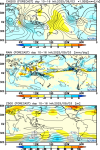
It’s far from over. This idea also being floated out by people that the east coast is somehow safe because fronts have dominated the season is very flawed thinking. They must forget about hurricane King, Donna, Hazel, and Sandy just to name a few all storms that came up from the Western Caribbean and hit the east coast. In fact, I argue the east coast of Florida is more vulnerable to a hurricane impact in October than August and September (especially if La Niña develops) because of how storms form in closer proximity to land. Plus even the wave coming off is no guarantee to curve even if the pattern is showing that right now long term. In fact the Euro ensembles have trended west already and it’s still very far out. This kind of stuff can really backfire big time with the media if they are not careful.
 
GFS has trended much further south and west. Still likely a fish storm but we’re still a week out from even approaching the islands so it has my attention for both the islands and U.S east coast.
Newest 12z operational GFS run has a Florence-like path, crashing straight into the east coast. Obviously still too far out to make any definite predictions on what it’ll do, but it just goes to show that this storm could still go anywhere. Looks like it’s once again dependent on whether or not a trough is positioned where it needs to be to “suck” it up.
 
Definitely gonna need to watch this system, progged to track further to the south and west than Erin.
ZCZC MIATWOAT ALL
TTAA00 KNHC DDHHMM

Tropical Weather Outlook
NWS National Hurricane Center Miami FL
800 PM EDT Wed Sep 3 2025

For the North Atlantic...Caribbean Sea and the Gulf of America:

1. Tropical Atlantic:
Showers and thunderstorms associated with a tropical wave located
over the eastern tropical Atlantic several hundred miles
west-southwest of the Cabo Verde Islands remain disorganized.
Environmental conditions are conducive for development of this
system during the next several days, and a tropical depression is
likely to form late this week or this weekend over the eastern or
central tropical Atlantic while moving slowly toward the
west-northwest at 5 to 10 mph. The system is likely to move faster
toward the west or west-northwest thereafter and reach the waters
east of the Lesser Antilles by the middle of next week.
* Formation chance through 48 hours...medium...40 percent.
* Formation chance through 7 days...high...80 percent.


Forecaster Berg
1756957995720.png
 
That cherry keeps shifting south and west and there's less model agreement than before about it turning out to sea...

That Sucks The Office GIF
 
It is now designated Invest 91L, and at the 2 PM Best Track update, the full suite of models should be running on it. Currently, only a subset of models have run on it.

I think it's very likely this storm (Gabrielle to be) will be more impactful than Erin. Hope I'm wrong, but just a gut feeling.
 
91L (blob to the WSW of Cabo Verde) is more organized than it was yesterday evening, and will likely start to grow into a tropical system over the next few days. It's in the classic corridor for significant hurricanes.
G19_sector_taw_band13_24fr_20250904-1211.gif
 
Back
Top