- Thread starter
- #921
Navigation
Install the app
How to install the app on iOS
Follow along with the video below to see how to install our site as a web app on your home screen.
Note: This feature may not be available in some browsers.
More options
-
Welcome to TalkWeather! We see you lurking around TalkWeather! Take the extra step and join us today to view attachments, see less ads and maybe even join the discussion. CLICK TO JOIN TALKWEATHER
You are using an out of date browser. It may not display this or other websites correctly.
You should upgrade or use an alternative browser.
You should upgrade or use an alternative browser.
2025 Atlantic Hurricane Season
- Thread starter Atlantic
- Start date
- Thread starter
- #922
We better hope not. Helene only added historic flooding to NC just days after Potential Tropical Cyclone Eight came through the same area but from off to the east, not from the south like Helene.sort of but hopefully not a helene or milton repeat
KakashiHatake2000
Member
Oh I see gotcha plus also that predecessor rain event tooWe better hope not. Helene only added historic flooding to NC just days after Potential Tropical Cyclone Eight came through the same area but from off to the east, not from the south like Helene.
- Thread starter
- #925
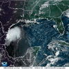
I don't notice any surface cirulation with it much though.Certainly an interesting feature, 98L is. Love watching how it interacts with passing cloud banks. Could develop into a depression as it wobbles across the NW Gulf the next little bit, but rain is the only real threat from it.
View attachment 46046
wx_guy
Member
- Messages
- 1,237
- Reaction score
- 4,443
- Location
- United States
- HAM Callsign
- KO4ZGH
- Special Affiliations
- SKYWARN® Volunteer
- ARRL Member
Wave down in the MDR now has a 20% chance in the next 7 days.
wx_guy
Member
- Messages
- 1,237
- Reaction score
- 4,443
- Location
- United States
- HAM Callsign
- KO4ZGH
- Special Affiliations
- SKYWARN® Volunteer
- ARRL Member
Wonder how soon before Invest 99L. May be today (either at 2 PM or 8 PM), or it may be another day or two. Will be nice to get the full suite of products on it.
Up to 40% mid-range chances from that MDR area of interest.
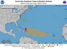
2. Central Tropical Atlantic:
A tropical wave located near the Cabo Verde Islands is producing
disorganized showers and thunderstorms. Some gradual development of
this system is possible during the latter half of this week, and a
tropical depression could form late this week or next weekend while
the system moves westward to west-northwestward at 15 to 20 mph,
approaching the northeastern Caribbean Sea or southwestern Atlantic.
* Formation chance through 48 hours...low...near 0 percent.
* Formation chance through 7 days...medium...40 percent.

wx_guy
Member
- Messages
- 1,237
- Reaction score
- 4,443
- Location
- United States
- HAM Callsign
- KO4ZGH
- Special Affiliations
- SKYWARN® Volunteer
- ARRL Member
Hoping we get Invest 99L tomorrow so we can better track it.
majorhurricane1703
Member
I know the 7 day outlook is up to 40%, but I don’t see this developing until closer to the islands where the oceanic heat content is higher to where it can compensate for mid level dry air. Too far south as well in my opinion to gain the kind of latitude north like Euro and ensembles show. I normally trust the Euro more, but don’t see it playing out like it says that it does here unless development happens faster. We’ll see though.Hoping we get Invest 99L tomorrow so we can better track it.
KakashiHatake2000
Member
https://hurricane-recon-viewer.replit.app/
i found another tool someone posted on americanwx in case if anyone wanted to try it out as they shared it with everyone on there
i found another tool someone posted on americanwx in case if anyone wanted to try it out as they shared it with everyone on there
notsoencrypted
Member
This is neat! Thanks for sharing it.https://hurricane-recon-viewer.replit.app/
i found another tool someone posted on americanwx in case if anyone wanted to try it out as they shared it with everyone on there
KakashiHatake2000
Member
yeah i know someone posted a screenshot and i figured someone would like it here and you are welcome
A lemon and an orange.
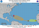
Erin, located near the Southeast Bahamas.
1. Tropical Atlantic:
A tropical wave located over the central tropical Atlantic is
producing some disorganized showers and thunderstorms. Environmental
conditions appear conducive for gradual development of this system,
and a tropical depression could form toward the end of the week.
This system should move westward to west-northwestward at about 20
mph across the central tropical Atlantic and approach the vicinity
of the Leeward Islands on Friday.
* Formation chance through 48 hours...low...10 percent.
* Formation chance through 7 days...medium...60 percent.
2. Eastern Tropical Atlantic:
A tropical wave located just off the coast of Africa is producing a
persistent cluster of disorganized showers and thunderstorms. Some
slight development of this system is possible over the next day or
two as it moves westward at around 15 mph. On Thursday, this system
should reach a less favorable environment, which should reduce its
chances for development.
* Formation chance through 48 hours...low...10 percent.
* Formation chance through 7 days...low...10 percent.
Forecaster Hagen

akt1985
Member
Right now it looks like the wave behind Erin will turn north out to sea before reaching the United States.
wx_guy
Member
- Messages
- 1,237
- Reaction score
- 4,443
- Location
- United States
- HAM Callsign
- KO4ZGH
- Special Affiliations
- SKYWARN® Volunteer
- ARRL Member
majorhurricane1703
Member
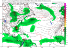
The GFS is 99.99% of the time out to lunch with ghost storms long term, but a hurricane in the western Gulf during the first week of September makes a ton of sense to me. The MJO will enter in phase 1 in September which fits the timeline perfectly for the GFS to develop a hurricane, a phase where the western Caribbean and Gulf are most favorable.
KakashiHatake2000
Member
some possible tropical development in the gulf in september it might be what majorhurricane1703 was refering to
Kds86z
Member
wx_guy
Member
- Messages
- 1,237
- Reaction score
- 4,443
- Location
- United States
- HAM Callsign
- KO4ZGH
- Special Affiliations
- SKYWARN® Volunteer
- ARRL Member

