• Welcome to TalkWeather!
    We see you lurking around TalkWeather! Take the extra step and join us today to view attachments, see less ads and maybe even join the discussion.
    CLICK TO JOIN TALKWEATHER

2025 Atlantic Hurricane Season

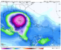
Orange and Lemon! The Orange is now Invest 95L.

1754230179678.png


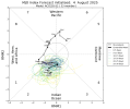
95L will be a fish storm looks like, but it could steal the name Dexter. The Lemon is up to 30% chances in the next 7 days, too.

1754230221612.png


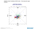
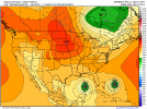
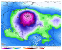
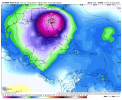
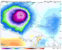
In other areas, the Google DeepMind AI is a little less enthused about the Gulf storm this morning, but still has several members (including a couple of hurricane-level ones) forming in 5-7 days. The two MDR areas (once of which is the Lemon, the other is behind it), the Google DeepMind AI has a ton of support for becoming hurricanes on both of them and generally drifts them westward. We have a week+ to watch these, though. But Erin and Fernand may be making an appearance during the first half of August, too, and maybe even Gabrielle.

The traditional dormant July is over, and we are now in the heart of the season! Buckle up cupcakes, it's going to be a bumpy ride.
 
And NOW we have a CHERRY, ORANGE, and a new LEMON!!! Cherry at 70% in 48 hours, other two are 40% in 7 days an 20% in 7 days.

I suspect we'll have at least a couple more fruits over the next few days!


1754245816055.png
 
August coming in roaring tropical weather wise! Hoping for minimal impacts and beautiful fish storms
I can't easily post Google's DeepMind AI run for 12z that just came out a bit ago because it's a a series of images, but I think everyone should look at it! (It's called Weather Lab: Cyclones, and yes, you have to log in to see it I believe) It features a parade of activity over the next 2 weeks, even more than previous runs. It shows 1) 95L, 2) the Orange area in the ATL, 3) the area near the east coast behind 95L, 4) The eastern Gulf, 5) and 6) Two more MDR systems behind the Orange, and 7) an Eastern Caribbean possible storm that moves west.

All in the next 14 days. Either it's going to take a huge L or it's seeing a gigantic awakening that's about to rock the basin.
I just saw it, that's incredible! If there's any amount of accuracy to what it's showing, I have a very sinking feeling about how this hurricane season may pan out barring odd middle-of-season shenanigans (2024 comes to mind). However, I find it particularly difficult to believe that there will be that many invests/PTCs at the same time.
 
Globals and newer AI models (like the above mentioned DeepMind model) are showing a strong signal for a potential large and powerful cyclone well west of the Hebert Box around D10-12.

Euro drops it to 920s near the Bahamas, GFS had it in the 930s off the coast of GA/FL and the Deep Mind models have an averaged intensity of Cat 3 near Florida.
 
According to both Australian and Euro MJO forecast, both stall it out in the favorable phases for a good amount of time. Your seeing the affects of it now as it rotates around. Robust Western Pacific activity has died out, Central Pacific activity has died out, Gonna get one more Eastern Pacific development, and now we are fixing to see a significant uptick in Atlantic activity. Probably thru at least September 15th. We'll see.
 

Attachments

  • mjo_rmm.daily.20250804.png
    mjo_rmm.daily.20250804.png
    191.3 KB · Views: 0
  • 20250805205207-f7ea88dfb93addab03078abff96266437e9d0bb0.png
    20250805205207-f7ea88dfb93addab03078abff96266437e9d0bb0.png
    340.1 KB · Views: 0
According to both Australian and Euro MJO forecast, both stall it out in the favorable phases for a good amount of time. Your seeing the affects of it now as it rotates around. Robust Western Pacific activity has died out, Central Pacific activity has died out, Gonna get one more Eastern Pacific development, and now we are fixing to see a significant uptick in Atlantic activity. Probably thru at least September 15th. We'll see.
Well that’s concerning. Especially since the models have been suggested on and off East Coast impacts from our 0/50 AoI tropical wave in the MDR region right now, the GFS especially.
 
Message to the MDR orange: if you become Erin and get retired I'm not gonna be happy to say the least.
I mean Erin is a famous name due to 9-11. Erin 2001 was near NYC as a weakening hurricane on 9-11-01.
 
The Euro AI Operational has been consistently showing the last 8 runs (4 from yesterday and the 4 from today) a strong tropical system around Florida by or just after August 20th. I am a bit surprised at all consistent it's been thus far. We'll see if it continues to show the next few days.
 
Once again, all 4 runs of today's Euro AI Operational are depicting a robust system around or after the 20th. A total of 12 consecutive runs now (beginning Tuesday thru today). Fixing to post about it on Patreon.
 

Attachments

  • ecmwf-aifs-all-caribbean-mslp_norm_anom-5820800.png 00z.png
    ecmwf-aifs-all-caribbean-mslp_norm_anom-5820800.png 00z.png
    106.9 KB · Views: 0
  • ecmwf-aifs-all-caribbean-mslp_norm_anom-5842400.png 6z.png
    ecmwf-aifs-all-caribbean-mslp_norm_anom-5842400.png 6z.png
    105.3 KB · Views: 0
  • ecmwf-aifs-all-caribbean-mslp_norm_anom-5864000.png 12z.png
    ecmwf-aifs-all-caribbean-mslp_norm_anom-5864000.png 12z.png
    105.5 KB · Views: 0
  • ecmwf-aifs-all-caribbean-mslp_norm_anom-5777600.png 18z.png
    ecmwf-aifs-all-caribbean-mslp_norm_anom-5777600.png 18z.png
    99.3 KB · Views: 0
Once again, all 4 runs of today's Euro AI Operational are depicting a robust system around or after the 20th. A total of 12 consecutive runs now (beginning Tuesday thru today). Fixing to post about it on Patreon.
This has my attention. 18Z GFS actually sent it almost directly over me despite me being several hundred miles inland as a 990 mb system
 
Once again, all 4 runs of today's Euro AI Operational are depicting a robust system around or after the 20th. A total of 12 consecutive runs now (beginning Tuesday thru today). Fixing to post about it on Patreon.
This is an unprecedented level of consistency for an AI model that far out -- this is, once again, a huge test for the AI models long range. The AI models are trained on historical patterns, so it's curious to see the very strong consistency. I am eagerly waiting for other models to "fall into line" on this, but it is a noteworthy amount of steady forecasting. I know the Euro AI and DeepMind AI are new, but do we have any verifications on their errors yet?
 
Back
Top