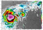
• Welcome to TalkWeather!
    We see you lurking around TalkWeather! Take the extra step and join us today to view attachments, see less ads and maybe even join the discussion.
    CLICK TO JOIN TALKWEATHER

2024 Atlantic Hurricane Season

Well Folks. This one has got my attention. Some cloud tops are -90 Celsius. Brrrrrrrr. Vorticities are Consolidating around this PTC Beast. Recon found 998Mb Pressure and the Campeche Buoy is down to 1003Mb. Another Flight is inbound.

I'm starting to think it can get to Cat-2/3 before the dry air wraps into the Center upon landfall, but a Hurricane Watches need to be issued immediately. It's already getting that look on its Southern Side.

d14c8171-f678-4b53-bd90-fb66aca2d22e.gif
 
Priorities, obviously, but 92L in the Central Atlantic also needs to be monitored. Could be a troublesome track if it materializes.
92L_tracks_latest.png
 
Also, anyone else noting PTC6 having 50 MPH MSW with TS force winds extending out quite far from the center?
095139_3day_cone_no_line_and_wind.png
 
Growing consensus that PTC6 will be designated Francine by 11 AM Eastern.
 
We officially have Tropical Storm Francis.

Center of circulation appears to be a little bit west of the model initialization, maybe 25-50 miles. This could have significant implications for landfall given then the angle of approach.

Although current models are centered around Vermillion Bay, If would not be letting my guard down in New Orleans right now.

Francis is also forecasted to have a large windfield, which will exacerbate the surge impacts.
 
First advisory calls for a hurricane of at least 85 MPH sustained winds at landfall. RI definitely in the ballpark of possibilities given heat content in the GOM.
095139_5day_cone_no_line_and_wind.png
 
Back
Top