
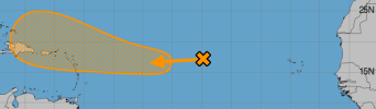
Carribean area go figure, there is support for it.
Navigation
Install the app
How to install the app on iOS
Follow along with the video below to see how to install our site as a web app on your home screen.
Note: This feature may not be available in some browsers.
More options
-
Welcome to TalkWeather! We see you lurking around TalkWeather! Take the extra step and join us today to view attachments, see less ads and maybe even join the discussion. CLICK TO JOIN TALKWEATHER
You are using an out of date browser. It may not display this or other websites correctly.
You should upgrade or use an alternative browser.
You should upgrade or use an alternative browser.
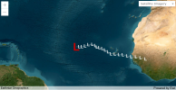
94L's track reminds me of Irma's track. Same area is projected to be affected right now too by the current Invest cone. It also seems the angle of the track models are predicting is similar too.
(Images from left to right: 94L's track as of now, second is the NHC's most recent take of 94L and last one is Hurricane Irma's track)
(Images from left to right: 94L's track as of now, second is the NHC's most recent take of 94L and last one is Hurricane Irma's track)
Attachments
Well this semi-verified well. We have gotten at least a sub-900 mb storm in Hurricane Milton.Imagine if we get another set of sub-890 mb storms like the pair that was 2005's Rita (885 mbs) and Wilma (882 mbs)
warneagle
Member
how about no
The track guideance is also very strong "no" material.how about no

slenker
Member
Saw a good amount of models (earlier) also hard-turning to the north and curving out to sea; hopefully that’s what happens instead.The track guideance is also very strong "no" material.
View attachment 31020
And you got Helene and Milton out of it...The Gulf of Mexico is an absolute powder keg. Record high levels of OHC locked and loaded.

If a storm has that pressure, we'd be dead.
wx_guy
Member
- Messages
- 1,237
- Reaction score
- 4,443
- Location
- United States
- HAM Callsign
- KO4ZGH
- Special Affiliations
- SKYWARN® Volunteer
- ARRL Member
Looks like the odds of 94L have reduced, so that's good. Either way, pretty confident it will stay away from the mainland.
- Thread starter
- #432
Your best bet would be here for the text: https://mesonet.agron.iastate.edu/w...ar2=2023&month2=5&day2=26&view=grid&order=ascDoes anyone know where to find TWO from before 2009 from the NHC?
Also, where can I find CPAC TC advisories on TC's prior to 2018?
Now, if you're looking for the TWO graphics, I have no idea how to find those. I've been wondering the same thing myself as I would love to see how much they've changed prior to 2009. As far as the CPAC advisories go prior to 18, I'm not sure how to find those.
wx_guy
Member
- Messages
- 1,237
- Reaction score
- 4,443
- Location
- United States
- HAM Callsign
- KO4ZGH
- Special Affiliations
- SKYWARN® Volunteer
- ARRL Member
This week's the season's last gasp, or more to come?
- Thread starter
- #434
More. We have PTC Fifteen soon and additional systems coming up in November.This week's the season's last gasp, or more to come?

wx_guy
Member
- Messages
- 1,237
- Reaction score
- 4,443
- Location
- United States
- HAM Callsign
- KO4ZGH
- Special Affiliations
- SKYWARN® Volunteer
- ARRL Member
94L back up to 30%
wx_guy
Member
- Messages
- 1,237
- Reaction score
- 4,443
- Location
- United States
- HAM Callsign
- KO4ZGH
- Special Affiliations
- SKYWARN® Volunteer
- ARRL Member
We now have TS Nadine and 94L up to 60%. Cooking.
jiharris0220
Member


Ah yes, vertical rotating hot towers, spiral banding, clear low level rotation, and even a nascent core on microwave imagery.
Mhm, definitely looks like an “invest” to me and definitely not a tropical storm or anything.
slenker
Member
Well, that was quick. I thought everyone was talking about how disorganized this thing was.View attachment 31065View attachment 31066
Ah yes, vertical rotating hot towers, spiral banding, clear low level rotation, and even a nascent core on microwave imagery.
Mhm, definitely looks like an “invest” to me and definitely not a tropical storm or anything.
wx_guy
Member
- Messages
- 1,237
- Reaction score
- 4,443
- Location
- United States
- HAM Callsign
- KO4ZGH
- Special Affiliations
- SKYWARN® Volunteer
- ARRL Member
Up to 90% on 94L now, looks like advisories could be issued soon as 11.