thundersnow
Member
The discussion from the NHC says there’s a trough to its east and a ridge to its west. These features are steering it southward, I assume.
Follow along with the video below to see how to install our site as a web app on your home screen.
Note: This feature may not be available in some browsers.

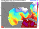
Thank you for posting this. I honestly haven't been looking at the operational models that much lately. Guess I start needing toView attachment 20426
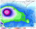
GFS has been pretty consistent for a few runs now showing development next weekend off Nicaragua and moving toward the gulf.
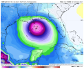


Invest 92L officially up
Yeah this is an extremely bizarre super late start to the east Pacific season for sure, ENSO isn't really affecting it super hard yet but not having anything thus far in a Niño year is very strange. The GFS has been showing multiple storms by the end of June in the past couple runs suddenly after being extremely quiet but given the GFS EPac bias over the last few years this remains to be seenThe Eastern Pacific basin since 1950 has had only 3 years where nothing formed in May or June. Those are 1953, 1957, and 1964.

If the next system behind TS Bret develops, it'll be the first time on record (going back to 1851) that two storms originated in the MDR in June.

Tropical Weather Outlook
NWS National Hurricane Center Miami FL
800 AM EDT Tue Jun 20 2023
For the North Atlantic...Caribbean Sea and the Gulf of Mexico:
Active Systems:
The National Hurricane Center is issuing advisories on Tropical
Storm Bret, located over the central tropical Atlantic.
1. Eastern Tropical Atlantic (AL93):
Showers and thunderstorms are gradually showing signs of
organization in association with a tropical wave located several
hundred miles southwest of the Cabo Verde Islands. Environmental
conditions appear conducive for further development of this system,
and a tropical depression will likely form during the next couple
of days while the system moves westward at 10 to 15 mph across the
eastern and central tropical Atlantic.
* Formation chance through 48 hours...high...70 percent.
* Formation chance through 7 days...high...80 percent.