• Welcome to TalkWeather!
    We see you lurking around TalkWeather! Take the extra step and join us today to view attachments, see less ads and maybe even join the discussion.
    CLICK TO JOIN TALKWEATHER
Logo 468x120

2023 Tropical Weather

Equus

Member
Messages
3,304
Reaction score
3,401
Location
Jasper, AL
Special Affiliations
  1. SKYWARN® Volunteer
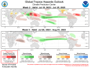
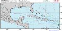
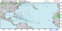
Bret has really pulled back together through the day, it was poorly vertically stacked earlier but tonight seems well stacked with robust convective bursting over the center and banding in multiple quads. Forward speed has dropped from 21 to 17 through the day; those fast low level trades were carrying it along much faster than the weak mid-level flow and imparting some shear, but now that it's slower that shear has relaxed just enough to let it take advantage of the highest oceanic heat content it will feel before starting to get sheared apart in a few days. Might near hurricane force IF this trend continues into the day but that's a big if.
 

Taylor Campbell

Moderator
Moderator
PerryW Project Supporter
Messages
2,127
Reaction score
2,226
Location
Wedowee, AL
Special Affiliations
  1. SKYWARN® Volunteer
Brett tried hard and made it to a 70mph tropical storm, but now destroyed by wind shear. Tropical Storm Cindy formed behind and expected to stay below hurricane status.
 

JPWX

Member
Messages
1,510
Reaction score
4,091
Location
Smithville MS
With Tropical Storm Adrian forming today in the Eastern Pacific, it is the latest first Eastern Pacific tropical system on record surpassing Hurricane Alvin in 2019.
 

JPWX

Member
Messages
1,510
Reaction score
4,091
Location
Smithville MS
With Hurricanes Adrian and Beatriz in the Eastern Pacific, here's the June's where the Eastern Pacific has had 2 hurricanes going back to 1950:

2018, 2015, 2011, 2010, 1996, 1991, 1989, 1985, 1984, 1978, 1976, 1974, and 1956.

Of those years, the first two names on the list became hurricanes in June of: 2018, 2011, 1996, and 1976.
 

Taylor Campbell

Moderator
Moderator
PerryW Project Supporter
Messages
2,127
Reaction score
2,226
Location
Wedowee, AL
Special Affiliations
  1. SKYWARN® Volunteer
There's impressive thunderstorm activity in West Africa. The models track a mid level presence to the Central Atlantic by weekend before dismissal. While there isn't significant development modeled with this disturbance we should keep an eye on it. Nevertheless, it could prove to be a sacraficial start to a more active period in the 7-14 day range.

goes16_ir_eatl.gif
 

JPWX

Member
Messages
1,510
Reaction score
4,091
Location
Smithville MS
With the first three storms of the season in the Eastern Pacific (Adrian, Beatriz, and Calvin) becoming hurricanes, it marks only the 6th year since 1950 where the first three named storms have strengthen to hurricane intensity. Other years are: 2015, 2011, 1995, 1971, and 1950. All but one (2015) were active to very active in the Atlantic.
 

Taylor Campbell

Moderator
Moderator
PerryW Project Supporter
Messages
2,127
Reaction score
2,226
Location
Wedowee, AL
Special Affiliations
  1. SKYWARN® Volunteer
What appears unusual to you in this picture?

IMG_0248.png
 

Taylor Campbell

Moderator
Moderator
PerryW Project Supporter
Messages
2,127
Reaction score
2,226
Location
Wedowee, AL
Special Affiliations
  1. SKYWARN® Volunteer
Peek-a-boo to the disturbed area over West Africa. The most recent GFS and EURO show further development when over the Atlantic and have it making a good ways west. Seems plausible.

IMG_0249.gif
 

JPWX

Member
Messages
1,510
Reaction score
4,091
Location
Smithville MS
Here's what the 00z Euro had.
 

Attachments

  • ecmwf-ensemble-avg-gulf-mslp_ens_min-1020800.png
    ecmwf-ensemble-avg-gulf-mslp_ens_min-1020800.png
    113 KB · Views: 0
  • eps_cyclones_gulf_360 (1).png
    eps_cyclones_gulf_360 (1).png
    93.3 KB · Views: 0
  • eps_cyclones_atlantic_360.png
    eps_cyclones_atlantic_360.png
    121.3 KB · Views: 0

Taylor Campbell

Moderator
Moderator
PerryW Project Supporter
Messages
2,127
Reaction score
2,226
Location
Wedowee, AL
Special Affiliations
  1. SKYWARN® Volunteer
There is a noticeable tropical feature on all the Global models approaching the Lesser Antilles next weekend.
 

JPWX

Member
Messages
1,510
Reaction score
4,091
Location
Smithville MS
Assuming I'm reading this right (orange as upward motion) and if the Euro is correct, August should turn out a busy month for the Atlantic basin.
 

Attachments

  • eps_chi200_anomaly_globe_2023072000_e50_1080.png
    eps_chi200_anomaly_globe_2023072000_e50_1080.png
    626.3 KB · Views: 0
  • eps_chi200_anomaly_globe_2023072000_e50_360.png
    eps_chi200_anomaly_globe_2023072000_e50_360.png
    641.1 KB · Views: 0
  • eps_chi200_anomaly_globe_2023072000_e50_480.png
    eps_chi200_anomaly_globe_2023072000_e50_480.png
    647.6 KB · Views: 0
  • eps_chi200_anomaly_globe_2023072000_e50_600.png
    eps_chi200_anomaly_globe_2023072000_e50_600.png
    648.8 KB · Views: 0
  • eps_chi200_anomaly_globe_2023072000_e50_720.png
    eps_chi200_anomaly_globe_2023072000_e50_720.png
    647 KB · Views: 0
  • eps_chi200_anomaly_globe_2023072000_e50_840.png
    eps_chi200_anomaly_globe_2023072000_e50_840.png
    642.3 KB · Views: 0
  • eps_chi200_anomaly_globe_2023072000_e50_960.png
    eps_chi200_anomaly_globe_2023072000_e50_960.png
    636.1 KB · Views: 0

Taylor Campbell

Moderator
Moderator
PerryW Project Supporter
Messages
2,127
Reaction score
2,226
Location
Wedowee, AL
Special Affiliations
  1. SKYWARN® Volunteer
On the GFS ensembles a faster system appears weaker and over the Lesser Antilles by Monday, July 31st. Whereas a stronger system is further north and east at the same time. With the operational consensus for a weaker system I lean towards the first scenario. The thunderstorm complex over Africa that’s suppose to ignite this system is large and active.

20582CFC-5F49-4E49-8161-E6399604ADF5.gif
 
Last edited:

JPWX

Member
Messages
1,510
Reaction score
4,091
Location
Smithville MS
With Typhoon Doksuri attaining category 4 intensity, it means there's been one category 5 in May and 1 category 4 now in July. The only years in the Western Pacific since 1950 that have had a category 5 in May and a category 4 in July are : 1991 (El Nino), 2000 (3 year La Nina), 2002 (El Nino), 2004 (Modoki El Nino), 2011 (La Nina), and 2015 (El Nino). With the exception of 1991, the rest of these 5 years featured at least 1 tropical system in the Gulf of Mexico. Furthermore, out of these years, the only season that had a hurricane impact on the Northeast coast was Hurricane Bob (1991).
 
Back
Top