
Pray that this is indeed the case!Regardless of how this is wrapping up, this looks like a situation where the tor may immediately occlude. Not a favorable look to support a sustained tornado for a bit, may be more quick surging spinups
Navigation
Install the app
How to install the app on iOS
Follow along with the video below to see how to install our site as a web app on your home screen.
Note: This feature may not be available in some browsers.
More options
-
Welcome to TalkWeather! We see you lurking around TalkWeather! Take the extra step and join us today to view attachments, see less ads and maybe even join the discussion. CLICK TO JOIN TALKWEATHER
You are using an out of date browser. It may not display this or other websites correctly.
You should upgrade or use an alternative browser.
You should upgrade or use an alternative browser.
2/19/26- 2/20/26 - severe threat discussion
- Thread starter WeathermanLeprechaun
- Start date
- Thread starter
- #302
WeathermanLeprechaun
Member
We are treading a very concerning situation right now for Bloomington. Please hopefully that occludes because this is not gonna be nice should it sustain... Sullivan, IN 2023 eque cell. Had a weird outflow look to it then it started dropping a sigtor instantly as soon as it wrapped up m
VultureDirge89
Member
Was not expecting to come home to this...Bloomington should really be under a PDS warning
EDIT: Of course they go for it literally as I'm writing that
EDIT: Of course they go for it literally as I'm writing that
slenker
Member
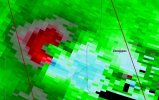
Looks like there’s something resembling a weak echo hole on the most recent scan of this thing: 
TornadoFan
Member
PDS warning issued for Bloomington!
Central Ohio Wx
Member
And there's your PDS. Would this-type situation warrant a TOR-E? I'm not well-versed in the CC and GTG criteria
Ozonelayer
Member
Bloomington under a PDS!
cincywx
Member
BULLETIN - EAS ACTIVATION REQUESTED
Tornado Warning
National Weather Service Indianapolis IN
701 PM EST Thu Feb 19 2026
The National Weather Service in Indianapolis has issued a
* Tornado Warning for...
Central Monroe County in south central Indiana...
Western Brown County in south central Indiana...
* Until 730 PM EST.
* At 701 PM EST, a confirmed large and extremely dangerous tornado
was located near Bloomington, moving east at 45 mph.
This is a PARTICULARLY DANGEROUS SITUATION. TAKE COVER NOW!
HAZARD...Damaging tornado.
SOURCE...Emergency management confirmed tornado.
IMPACT...You are in a life-threatening situation. Flying debris
may be deadly to those caught without shelter. Mobile
homes will be destroyed. Considerable damage to homes,
businesses, and vehicles is likely and complete
destruction is possible.
* Locations impacted include...
Bloomington, Ellettsville, Yellowwood Lake, Indiana University,
Woodville Hills, Lake Lemon, Unionville, and Whitehall.
TornadoFan
Member

- Thread starter
- #310
WeathermanLeprechaun
Member

- Thread starter
- #312
WeathermanLeprechaun
Member
EXTREMELY DANGEROUS tornado heading into Bloomington. major situation. Please hope or pray guys
TDS coming right into Bloomington, just hit the airport.
There’s a criteria, but each office seems to have their own. I don’t recall it off the top of my head, but it’s a very high GTG/VROT as well significant debris lofting.And there's your PDS. Would this-type situation warrant a TOR-E? I'm not well-versed in the CC and GTG criteria
warneagle
Member
It's gonna go right over campus too on the current trackTDS coming right into Bloomington, just hit the airport.
Jason Mills
Member
This is a good candidate for a TORE
Ozonelayer
Member
This is a worst case scenario. Prayung everyone is sheltered because excuse my language but holy excrement, thats over Highland Village right now.

Central Ohio Wx
Member
Could also hit the Memorial Stadium with the way it's going.
Kds86z
Member
Kolle
Member
Wind gusts of 70mph at that airport.TDS coming right into Bloomington, just hit the airport.