
I think we are seeing the beginning of the main event for Alabama developing back in Miss. Notice how the precip is filling in between both bands-southern and northern. This will be arriving as the 850mb level continues to chill causing snow around I20...probably heavy for an hour or two starting around 5pm. North of that zone, just a dusting, snow will extend south toward Montgomery with less amounts
Navigation
Install the app
How to install the app on iOS
Follow along with the video below to see how to install our site as a web app on your home screen.
Note: This feature may not be available in some browsers.
More options
-
Welcome to TalkWeather! We see you lurking around TalkWeather! Take the extra step and join us today to view attachments, see less ads and maybe even join the discussion. CLICK TO JOIN TALKWEATHER
You are using an out of date browser. It may not display this or other websites correctly.
You should upgrade or use an alternative browser.
You should upgrade or use an alternative browser.
1/6-1/7 Winter Storm Potential Thread
- Thread starter Tyler Penland
- Start date
ShowMeYourTDs
Member
Trying to figure out how in the hell my temp keeps going down with a wind out of the SE. Went from 37 to 34.2 in the last 30 minutes. Even with a rain shower...(head scratching).
Has anyone seen the sounding from KATL or KPDK? Would love to see where the warm nose is at the moment.
Has anyone seen the sounding from KATL or KPDK? Would love to see where the warm nose is at the moment.
Psalm 148:8
Member
And this means??? Translation for those like me who are unsure....
The big picture tells the tale...
VegasEagle
Member
Nice post! I agree. Just wish it would snow more in north Alabama. I have a bet riding on it.I think we are seeing the beginning of the main event for Alabama developing back in Miss. Notice how the precip is filling in between both bands-southern and northern. This will be arriving as the 850mb level continues to chill causing snow around I20...probably heavy for an hour or two starting around 5pm. North of that zone, just a dusting, snow will extend south toward Montgomery with less amounts
ARCC
Member
Trying to figure out how in the hell my temp keeps going down with a wind out of the SE. Went from 37 to 34.2 in the last 30 minutes. Even with a rain shower...(head scratching).
Has anyone seen the sounding from KATL or KPDK? Would love to see where the warm nose is at the moment.
You a probably wet bulbing as the humidity rises.
ZR continues here. Glaze is getting thicker on trees. I imagine I have a another hour or so until solar radiation decreases and it starts to build on everything.
- Moderator
- #406
No snow here, but it sure is cold. 26 degrees. Looks like West Tennessee and parts of Northwest Mississippi made out alright this morning with 2-4 inches in places.
ShowMeYourTDs
Member
Now down to 33.8 with .03 inches of rainfall. Gonna be scary close if I can wet bulb down to 32. Current WB is at 32.18.
CoreyandFrosty
Member
Ice forming on some trees on my deck here on the NW side of Atlanta.
Brax
Member
Trying to figure out how in the hell my temp keeps going down with a wind out of the SE. Went from 37 to 34.2 in the last 30 minutes. Even with a rain shower...(head scratching).
Has anyone seen the sounding from KATL or KPDK? Would love to see where the warm nose is at the moment.
If it's raining, you're likely experiencing evaporative cooling. Eventually, once the humidity is 100% you'll reach the limit of this ability (called the WetBulb temp.)
And this means??? Translation for those like me who are unsure....
Water vapor satellite image showing surface low/trough in the western gulf, firing off waves of moisture up an over the cold air mass in place.
Psalm 148:8
Member
Thanks! I'll take all the moisture I can get!
tagat
Member
Spann's twitter:
Psalm 148:8
Member
Nice slug of moisture coming out of LA and Miss.
bingcrosbyb
Member
SREF mean up to 2.48" of snow for Birmingham. Primary window from 6pm to midnight.
tagat
Member
Mesoscale Discussion 21
< Previous MD

Mesoscale Discussion 0021
NWS Storm Prediction Center Norman OK
0209 PM CST Fri Jan 06 2017
Areas affected...Mixed precipitation - freezing rain and sleet
Concerning...Winter mixed precipitation
Valid 062009Z - 070215Z
SUMMARY...Freezing rain and sleet will increase along a corridor
from central LA, across central MS, into central AL this
afternoon/evening. Significant icing, with rates approaching .10
inch/hr in heavier convection, is expected.
DISCUSSION...Latest vis satellite imagery exhibits deepening
convection across the lower Sabine river valley extending into
southern portions of MS. Lightning is increasing within the taller
updrafts, partly in response to increasing ascent ahead of
approaching short-wave trough. An elongated corridor of
precipitation, with embedded thunderstorms, is expected to expand in
areal coverage/intensity over the next several hours from the lower
Mississippi Valley to the central Gulf states.
With boundary-layer temperatures expected to cool a few degrees
along this corridor it appears the risk for significant icing will
increase as the afternoon progresses into the evening hours. As the
cold air deepens, sleet will become common along the nrn edge of
this expanding precip shield. With time, mixed precipitation will
spread into northern GA later this evening.
..Darrow.. 01/06/2017
< Previous MD
Mesoscale Discussion 0021
NWS Storm Prediction Center Norman OK
0209 PM CST Fri Jan 06 2017
Areas affected...Mixed precipitation - freezing rain and sleet
Concerning...Winter mixed precipitation
Valid 062009Z - 070215Z
SUMMARY...Freezing rain and sleet will increase along a corridor
from central LA, across central MS, into central AL this
afternoon/evening. Significant icing, with rates approaching .10
inch/hr in heavier convection, is expected.
DISCUSSION...Latest vis satellite imagery exhibits deepening
convection across the lower Sabine river valley extending into
southern portions of MS. Lightning is increasing within the taller
updrafts, partly in response to increasing ascent ahead of
approaching short-wave trough. An elongated corridor of
precipitation, with embedded thunderstorms, is expected to expand in
areal coverage/intensity over the next several hours from the lower
Mississippi Valley to the central Gulf states.
With boundary-layer temperatures expected to cool a few degrees
along this corridor it appears the risk for significant icing will
increase as the afternoon progresses into the evening hours. As the
cold air deepens, sleet will become common along the nrn edge of
this expanding precip shield. With time, mixed precipitation will
spread into northern GA later this evening.
..Darrow.. 01/06/2017
MikeP
Member
Well that sucks
ARCC
Member
Temp now down to 31, light ZR continues.
Ryan Sanders
Member
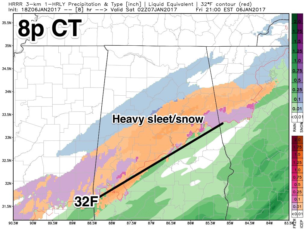
HHHR 19Z has a much larger area of snow accumulation for Alabama compared to 18z. But nothing exceeding 3".
ShowMeYourTDs
Member
Down to 33.5, .05in of rain. Miserable. FFC has introduced more ZR/IP for my forecast...Combined sleet & snow accum down to 1-3, vs the bullish 3-5 earlier.
Last edited: