• System Update
    TalkWeather will have sporatic outages on Monday, Nov 17, 2025 from 10:30pm - 11:30pm.
  • Welcome to TalkWeather!
    We see you lurking around TalkWeather! Take the extra step and join us today to view attachments, see less ads and maybe even join the discussion.
    CLICK TO JOIN TALKWEATHER

Significant Tornado Events

Today marks the 20 year anniversary of a tornado outbreak that helped fuel my life long passion for severe weather. 12 tornadoes struck central Iowa and 3 of them were significant.

It was an exceptionally rare outbreak.

The Nov. 12, 2005, tornadoes were Iowa's first November tornadoes in 14 years and the largest November outbreak up to that point in history.

Prior to that day, only 23 November tornadoes had been recorded in the state since 1950.

Of the dozen twisters in this outbreak, three also achieved F2 or greater intensity. Two of those significant tornadoes were on the ground simultaneously, and both struck towns.

Iowa's next November tornadoes would come almost exactly 10 years later on Veterans Day 2015.


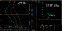
Saturday November 12th 2005 started with the Stratford, Iowa F3

1762992868348.png
1762992887730.png
1762992913664.png

At the same time an F2 tornado struck Woodward, Iowa, and this legendary video was recorded. The outbreak was later featured on the Weather Channel show "Storm Stories".


1762993185583.png
1762993252800.png
1762993283419.png

 
Plus the thermal boundaries left over. 4/27 was simply as perfect as a tornadic setup we have ever seen. I still think that something above 4/27/11 with like 3,000 CAPE or higher with more extreme kinematics is possible but extraordinarily rare to combine.
This may seem like a hot take, but to me, the most anomalous factor in both super outbreaks isn’t the environment. Don’t get me wrong, those are 99th percentile environments. It’s actually the large number of open warm sector discrete supercells that fired.

A verified high risk day may have 3-4 cells go up and produce the majority of an outbreak’s tornados. On both of those days you had 25+ supercells go up.

While it’s not 100% accurate to the environment that day, I’ve looked at a lot of the reanalysis data sets for ‘74 as well as RAP proximity soundings from ‘11. One thing that I found interesting is that the Xenia, Rainsville, and the two Jackson Co. EF4s weren’t necessarily in an extreme parameter space. Very upper end kinematics, but CAPE was around 1500 IIRC. Almost seems like when you get that many mature discrete supercells, with such a wide geographic warm sector, they’ll drop violent tornados even in the relatively “lesser extreme spaces”.
I think a combination of the two is what really produces a super outbreak, but the large number of supercells can definitely be considered the main reason why super outbreaks occur. We've seen a lot of instances where mature supercells enter into hostile environments after leaving the area of most favorable ingredients and still produce strong to violent tornadoes - Enderlin, Greensburg, West Liberty, and Cookeville to name a few. The increased amount of discrete supercells on the higher end days simply allows for a higher chance for an increased quantity of mature supercells to leave the primed parameter space but still be steady-state enough to maintain and continue producing, so that definitely allows for higher chances of more strong to violent tornadoes. The eastern tornadoes of 4/27/11 and the northern tornadoes on 4/3/1974 are evidence enough of this.

I don't know if it is necessarily fully comparable because introducing this may lead to issues with the environment of its own, but I imagine if 3/14 had something similar to confluence bands out ahead of the "string of pearls" supercell front it had, we may have had many more violent tornadoes that day, and definitely would have had more strong ones. 3/14 contained an environment that was absolutely comparable to super outbreaks we have had in the past, it just didn't have as many discrete supercells. (Also, MEG was surveying some of the damage. Bakersfield was an EF4).
 
Last edited:
I don't know if it is necessarily fully comparable because introducing this may lead to issues with the environment of its own, but I imagine if 3/14 had something similar to confluence bands out ahead of the "string of pearls" supercell front it had, we may have had many more violent tornadoes that day, and definitely would have had more strong ones. 3/14 contained an environment that was absolutely comparable to super outbreaks we have had in the past, it just didn't have as many discrete supercells. (Also, MEG was surveying some of the damage. Bakersfield was an EF4).
I would concur with that. Especially in the southern Ark/Mississippi area. Imagine if the warm nose wasn’t as stubborn as it was. There were plenty of convective initiation attempts that night. We could’ve had a string of pearls all the way from southern Missouri to southern Mississippi. Then couple that with a few confluence bands out into Tennessee. Really not hard to imagine a super outbreak scenario.

Re: 74. I’ve always found convective band 2, which was responsible for the vast majority of violent tornados that day, the most intriguing. It seems like there were “mini bands” within band #2.

The northern Kentucky/Central & Southern Indiana storms in one mini band. This band seemed to have initiated on a confluence band induced by channeling of winds by the Mississippi River valley coupled with ascent from the trough.

The Central and Southern Kentucky & Central and Northern Tennessee storms in the next mini band. I theorize this may have been the same confluence band as above, or one formed from similar mechanisms. Storms took a while longer to fire on this band due to a more stubborn cap in this area. However, they were primed to go. I watched an interview from a central TN meteorologist on staff that day who stated once the temperature in TN hit 80 degrees, cloud tops hit 60000 feet in minutes.

And finally the southern Tennessee and infamous Alabama storms in the third. Here is a surface map from Corfidi’s 1974 paper from 2100 UTC. Very clear areas of confluence in northeastern Mississippi and central Mississippi.

Seems like you need very wide swaths of open warm sector lift to produce a high numbers of supercells like you said.
1762999679787.png
 
The overall aerial expanse of the warm sector/favorable parameter space is one of the main things that sets apart 4/3/1974 and 4/27/2011 from other events. You need a wide warm sector so storms have time to mature without running out of instability, and it does need to be far enough north so that enough storms stay within the moist air. 3/14 this year was a bit of a "just in time" moisture scenario where the warm sector was not quite as large/dewpoints as high.

12/10/2021 was another event that had a very large warm sector and yielded a historic event for the time of year. With that said, there weren't as many supercells with that event because the northern mode was primarily a QLCS and there wasn't quite enough forcing for storms further south into LA and MS. Also the fact that it was December (less time for heating, just cooler in general) did generally limit CAPE to the 1000-2000 J/kg range vs. the 3000+ present in some of the big April events.
 
This may seem like a hot take, but to me, the most anomalous factor in both super outbreaks isn’t the environment. Don’t get me wrong, those are 99th percentile environments. It’s actually the large number of open warm sector discrete supercells that fired.

A verified high risk day may have 3-4 cells go up and produce the majority of an outbreak’s tornados. On both of those days you had 25+ supercells go up.

While it’s not 100% accurate to the environment that day, I’ve looked at a lot of the reanalysis data sets for ‘74 as well as RAP proximity soundings from ‘11. One thing that I found interesting is that the Xenia, Rainsville, and the two Jackson Co. EF4s weren’t necessarily in an extreme parameter space. Very upper end kinematics, but CAPE was around 1500 IIRC. Almost seems like when you get that many mature discrete supercells, with such a wide geographic warm sector, they’ll drop violent tornados even in the relatively “lesser extreme spaces”.
You have a very fair point and i do agree with you, probably should've touched on that.


Regarding how violent tornadoes can happen in less extreme environments, i just discussed hypothetically the very upper end thermodynamics for a super outbreak. Violent tornadoes have happened in 300-400 CAPE (2/6/08 in Alabama)

Storm scale interactions likely boost the potential of those supercells but 1.5k is very exquisite for violent tornadoes given the right spacing and environment.

Your warm sector matters a lot and how storms initiate + their orientation additionally. 3/14 really did have a very wide range of significant tor potential, and the general matter was the southern mode was more of a glancing blow. 4/2 should also land itself in there, the MCDs that day mentioned or referred to intense to violent tornadoes as far as Kentucky if storms cooperated. Had overheating not stopped the early portion of the event, 4/2 could've truly been well worse then it already turned out.

People I've seen on low IQ X call 4/2 a low end 30% hatched but i think it performed fairly decent and the forecast certainly justified + verified a significant tornado outbreak with several EF3s plus one arguable EF4 which is Lake City.

3/15 without crapvection? Likely one of the most potent outbreaks seen in ages given very favorable warm sector plus kinematics.

We get luckier then people realise and that high end setups actually are more common then we think but failure modes thankfully are mostly productive on many and then other times like 3/14, the high end solution verifies. The environment that day truly was upper echelon and had a stronger 500 mb jet translation based off the OMEGA. I emailed Broyles and got the OMEGA data for 1950 to now and it was notable that 1/12/23 would've verified a high risk!
 
The overall aerial expanse of the warm sector/favorable parameter space is one of the main things that sets apart 4/3/1974 and 4/27/2011 from other events. You need a wide warm sector so storms have time to mature without running out of instability, and it does need to be far enough north so that enough storms stay within the moist air. 3/14 this year was a bit of a "just in time" moisture scenario where the warm sector was not quite as large/dewpoints as high.

12/10/2021 was another event that had a very large warm sector and yielded a historic event for the time of year. With that said, there weren't as many supercells with that event because the northern mode was primarily a QLCS and there wasn't quite enough forcing for storms further south into LA and MS. Also the fact that it was December (less time for heating, just cooler in general) did generally limit CAPE to the 1000-2000 J/kg range vs. the 3000+ present in some of the big April events.
Very, very important. When cells have a large OWS to go into, they can mature. There's a reason so many crowded events underperform because storms can't properly mature with such a small region to push into 60+ dew points and often, they are already out of the most favorable parameter space when they organise.

12/10 was pretty impressive and it's no doubt that the large warm sector undoubtedly helped + some of those shortwaves promoting strong moisture all the way into KY/TN/IL too (Plenty of significant tornadoes occurred up north within that broken line of sorts) it really is in the most upper echelon December synoptic setups you can get. 12/28 last year earning a spot in 2nd after that too.
 
You have a very fair point and i do agree with you, probably should've touched on that.


Regarding how violent tornadoes can happen in less extreme environments, i just discussed hypothetically the very upper end thermodynamics for a super outbreak. Violent tornadoes have happened in 300-400 CAPE (2/6/08 in Alabama)

Storm scale interactions likely boost the potential of those supercells but 1.5k is very exquisite for violent tornadoes given the right spacing and environment.

Your warm sector matters a lot and how storms initiate + their orientation additionally. 3/14 really did have a very wide range of significant tor potential, and the general matter was the southern mode was more of a glancing blow. 4/2 should also land itself in there, the MCDs that day mentioned or referred to intense to violent tornadoes as far as Kentucky if storms cooperated. Had overheating not stopped the early portion of the event, 4/2 could've truly been well worse then it already turned out.

People I've seen on low IQ X call 4/2 a low end 30% hatched but i think it performed fairly decent and the forecast certainly justified + verified a significant tornado outbreak with several EF3s plus one arguable EF4 which is Lake City.

3/15 without crapvection? Likely one of the most potent outbreaks seen in ages given very favorable warm sector plus kinematics.

We get luckier then people realise and that high end setups actually are more common then we think but failure modes thankfully are mostly productive on many and then other times like 3/14, the high end solution verifies. The environment that day truly was upper echelon and had a stronger 500 mb jet translation based off the OMEGA. I emailed Broyles and got the OMEGA data for 1950 to now and it was notable that 1/12/23 would've verified a high risk!
lowest cape Violent tornado ive found had
MLCAPE : 0
MLCIN : 0
MLLCL :681 Meters

SBCAPE : 17
MUCAPE : 116

SRH1 : 406

Every other official EF5 had 1000+ MLCAPE it seems
Every other official EF4 had 20+ MLCAPE
1763061792438.png
 
View attachment 48620
Pretty impressive aerial of the damage swath from the 2013 Moore, OK EF5 before it entered the city.
The damage that Moore 2013 produced was truly unbelievable.

And no I'm not lying but Moore was practically a mesoscale accident. There was poor low level shear but the supercell managed to wrap up with numerous mergers and produced a incredibly violent tornado given the instability in place. The environment wasn't that great for tornadoes.
1763073267321.png

Counterpoint: this 17-18z sounding from OUN is more than supportive of significant supercells/tornadoes as is. With enhanced low level shear in the vicinity of the boundary, that becomes even more volatile.
 
View attachment 48621

Counterpoint: this 17-18z sounding from OUN is more than supportive of significant supercells/tornadoes as is. With enhanced low level shear in the vicinity of the boundary, that becomes even more volatile.
The environment still supported a couple tornadoes of course with that balance of 120+ 0-1km SRH (Better shear then i remembered) but this sounding, you would've never thought a EF5 had come out of it regardless. That's due to those inflow mergers of sorts, and very importantly, the boundary.
 
The damage that Moore 2013 produced was truly unbelievable.

And no I'm not lying but Moore was practically a mesoscale accident. There was poor low level shear but the supercell managed to wrap up with numerous mergers and produced a incredibly violent tornado given the instability in place. The environment wasn't that great for tornadoes.
Highly recommend Chris Broyles' video on Moore 2013:


In short, it was hypothesized a very small scale mid-level jet interacted with the Moore supercell - which in conjunction with the descending reflectivity cores and other storm scale processes, modified the environment to be much more typical of extremely violent tornadoes, on a very small scale.

1763073547813.png1763073576963.png

To be honest - Moore is probably one of the best examples I can think of an absolute worst-case scenario. The odds of the meso-beta scale jet interacting with the supercell, which itself had an 'ideal' storm-scale interaction, to produce an extremely violent tornado, right as it entered a highly populated area, would have been exceptionally low. But it happened. Horrifying.
 

Attachments

  • 1763073523193.png
    1763073523193.png
    1.3 MB · Views: 0
Highly recommend Chris Broyles' video on Moore 2013:


In short, it was hypothesized a very small scale mid-level jet interacted with the Moore supercell - which in conjunction with the descending reflectivity cores and other storm scale processes, modified the environment to be much more typical of extremely violent tornadoes, on a very small scale.

View attachment 48623View attachment 48624

To be honest - Moore is probably one of the best examples I can think of an absolute worst-case scenario. The odds of the meso-beta scale jet interacting with the supercell, which itself had an 'ideal' storm-scale interaction, to produce an extremely violent tornado, right as it entered a highly populated area, would have been exceptionally low. But it happened. Horrifying.

Oh, actually, yeah! I forgot about that mid level jet they said interacted with it. That sounding is FAR more supportive of strong-violent tornadoes, and with the boundary plus several mesoscale processes likely boosted the shear to a extreme amount. Adding unneeded fuel to the fire pretty much. As you said, the odds of something so incredibly subtle just interacting with this supercell in a area that got hit by a simply unprecedented tornado on 5/3/99 only to drop a tornado that rivals it in intensity RIGHT over the area, 14 years, 17 days later. It's just so unfortunate. I believe some sort of boundary also influenced the March 2015 "wind damage" in Moore as it was called despite it being a clear leading edge tornado.

That city just has a very unlucky history.
 
I think it was officially classified as an EF2 tornado if i remember correctly
Yeah they slowly walked that one back after being caught with their pants down. I distinctly remember how the narrative went from straight line winds, to straight line winds with embedded gustnado activity, to a mix of gustnado activity and weak tornadic spin ups, to an EF2 tornado tracking through the metro.
 
Yeah they slowly walked that one back after being caught with their pants down. I distinctly remember how the narrative went from straight line winds, to straight line winds with embedded gustnado activity, to a mix of gustnado activity and weak tornadic spin ups, to an EF2 tornado tracking through the metro.
In fact, that EF2 rating is itself probably too low. An argument exists for an EF3 rating.

Nowhere near the worst rating call even from that office that decade, though... *Glares at like a full dozen blatantly EF5 homes in Goldsby being rated EF4, along with another good EF5 candidate getting snubbed at the same time*
 
  • Like
Reactions: AJS
The overall aerial expanse of the warm sector/favorable parameter space is one of the main things that sets apart 4/3/1974 and 4/27/2011 from other events. You need a wide warm sector so storms have time to mature without running out of instability, and it does need to be far enough north so that enough storms stay within the moist air. 3/14 this year was a bit of a "just in time" moisture scenario where the warm sector was not quite as large/dewpoints as high.

12/10/2021 was another event that had a very large warm sector and yielded a historic event for the time of year. With that said, there weren't as many supercells with that event because the northern mode was primarily a QLCS and there wasn't quite enough forcing for storms further south into LA and MS. Also the fact that it was December (less time for heating, just cooler in general) did generally limit CAPE to the 1000-2000 J/kg range vs. the 3000+ present in some of the big April events.
1974 was actually much more expansive IMO, albeit less dense on the viotors (blues and blacks are violent)
1763142947396.png1763142962611.png
 

Attachments

  • 1763142953396.png
    1763142953396.png
    105.4 KB · Views: 0
1974 was actually much more expansive IMO, albeit less dense on the viotors (blues and blacks are violent)
View attachment 48634View attachment 48636
4/27/11 did have a warm sector spanning up to southern Ohio, and significant-potentially violent tornadoes were possible up there too. It's still not as expansive as 4/3 but was a bit more closer.

I believe that airmass recovery issues shut off the northern sector of the event unlike the opposite down south. I'd have to think the role of being further north from strong WAA would play a part into that, whereas MS/AL/Georgia had warm air surging in by morning. There was also less time for the northern portion to recover. The earlier your junk convection is out, the more likely things may set off.
 
Back
Top