This may seem like a hot take, but to me, the most anomalous factor in both super outbreaks isn’t the environment. Don’t get me wrong, those are 99th percentile environments. It’s actually the large number of open warm sector discrete supercells that fired.Plus the thermal boundaries left over. 4/27 was simply as perfect as a tornadic setup we have ever seen. I still think that something above 4/27/11 with like 3,000 CAPE or higher with more extreme kinematics is possible but extraordinarily rare to combine.
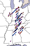
A verified high risk day may have 3-4 cells go up and produce the majority of an outbreak’s tornados. On both of those days you had 25+ supercells go up.
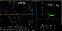
While it’s not 100% accurate to the environment that day, I’ve looked at a lot of the reanalysis data sets for ‘74 as well as RAP proximity soundings from ‘11. One thing that I found interesting is that the Xenia, Rainsville, and the two Jackson Co. EF4s weren’t necessarily in an extreme parameter space. Very upper end kinematics, but CAPE was around 1500 IIRC. Almost seems like when you get that many mature discrete supercells, with such a wide geographic warm sector, they’ll drop violent tornados even in the relatively “lesser extreme spaces”.