• Welcome to TalkWeather!
    We see you lurking around TalkWeather! Take the extra step and join us today to view attachments, see less ads and maybe even join the discussion.
    CLICK TO JOIN TALKWEATHER

Hurricane Ian

Messages
491
Reaction score
405
Location
Northern Europe
Also, the photos I've seen of wind damage from Hurricane Ian look pretty intense to me - not as intense as Andrew or Dorian, sure, but then again you have to remember those are extreme examples.
^ @TH2002 Please take a look at images of coconut palms on the beachfront in Fort Myers Beach. Note that palms on the immediate waterfront, on the right edge of the preceding image, show virtually no injury to their fronds. Those palms appear to be approximately 30’ tall, well above the surge that was documented at the same location. Storm chaser Max Olson’s camera was approximately 12’ above ground level, yet the palms that are covered by water in his footage appear to be ~6’ AGL, and the TCR mentions that this was partly due to waves rather than surge. So those 30’ palms would have escaped wave-and-surge-related damage to their fronds, indicating that the absence of visible damage was due to a lack of 130-kt wind rather than being covered by water. Fort Myers Beach, being sited in the southeastern eyewall, experienced the strongest winds and peak surge in Ian, which would have been in the southeastern quadrant of a northeastward-curving hurricane. Had MSW of 130 kt been present, the palms would have shredded, the surge would have been higher, and the video would not have survived to begin with. For example, take a look at coconut palms on the shoreline in Miami Beach following the passage of the northeastern quadrant of the 1926 Miami hurricane, which was 125 kt at LF. Those palms’ fronds were completely shredded, despite an absence of big surge on the Atlantic coast of South Florida.
 

SouthFLwx

Member
Messages
86
Reaction score
98
Location
Boca Raton, Florida
^ @TH2002 Please take a look at images of coconut palms on the beachfront in Fort Myers Beach. Note that palms on the immediate waterfront, on the right edge of the preceding image, show virtually no injury to their fronds. Those palms appear to be approximately 30’ tall, well above the surge that was documented at the same location. Storm chaser Max Olson’s camera was approximately 12’ above ground level, yet the palms that are covered by water in his footage appear to be ~6’ AGL, and the TCR mentions that this was partly due to waves rather than surge. So those 30’ palms would have escaped wave-and-surge-related damage to their fronds, indicating that the absence of visible damage was due to a lack of 130-kt wind rather than being covered by water. Fort Myers Beach, being sited in the southeastern eyewall, experienced the strongest winds and peak surge in Ian, which would have been in the southeastern quadrant of a northeastward-curving hurricane. Had MSW of 130 kt been present, the palms would have shredded, the surge would have been higher, and the video would not have survived to begin with. For example, take a look at coconut palms on the shoreline in Miami Beach following the passage of the northeastern quadrant of the 1926 Miami hurricane, which was 125 kt at LF. Those palms’ fronds were completely shredded, despite an absence of big surge on the Atlantic coast of South Florida.
Do you realize how resilient coconut palms are?
 

SouthFLwx

Member
Messages
86
Reaction score
98
Location
Boca Raton, Florida
Yes, but why did 130-kt Ian barely do any damage to coconut palms on the beachfront vs. the 125-kt Miami hurricane of 1926? The palms were exposed to the strongest winds in both cases.
Hurricane Ian's strongest winds didn't hit Ft. Myers Beach. They were located in the western quadrant of the eyewall (which is where the deepest convection was), confined to a small area, and there is a very real chance that they didn't even make it onshore due to land friction.
 
Messages
491
Reaction score
405
Location
Northern Europe
Hurricane Ian's strongest winds didn't hit Ft. Myers Beach. They were located in the western quadrant of the eyewall (which is where the deepest convection was), confined to a small area, and there is a very real chance that they didn't even make it onshore due to land friction.
Given that Ian was moving north of due east during landfall, why would that possibly have been the case? Wouldn’t the strongest surface winds have occurred south and east of the eye, given forward trajectory? I know that radar and aircraft indicated that the strongest winds were in the western quadrant, but reconnaissance measured FL winds of 133 kt SSE of the eye at 1758Z, about an hour prior to LF, which would indicate 10-m winds of ~120 kt. I’d imagine that 120-kt winds would cause a lot more visible damage to those coconut palms than is shown. As mentioned above, the 1926 hurricane was 125 kt at LF and completely shredded beachfront coconut palms, so, if anything, even winds of less than 120 kt would have caused greater damage than is visible in the imagery, unless there is another explanation...

At 3:49 the following video does show stripped coconut palms. But these seem to have been subject to wind-tunnelling behind the condominium, for nearby coconut palms on the waterfront do not show the same degree of injury (4:55 shows this quite well):


Bottom line: I myself am surprised. The reconnaissance data would certainly support the NHC’s MSW of 130 kt at LF. My question is, Why doesn’t the damage seem to add up?
 
Last edited:

SouthFLwx

Member
Messages
86
Reaction score
98
Location
Boca Raton, Florida
Given that Ian was moving north of due east during landfall, why would that possibly have been the case? Wouldn’t the strongest surface winds have occurred south and east of the eye, given forward trajectory? I know that radar and aircraft indicated that the strongest winds were in the western quadrant, but reconnaissance measured FL winds of 133 kt SSE of the eye at 1758Z, about an hour prior to LF, which would indicate 10-m winds of ~120 kt. I’d imagine that 120-kt winds would cause a lot more visible damage to those coconut palms than is shown. As mentioned above, the 1926 hurricane was 125 kt at LF and completely shredded beachfront coconut palms, so, if anything, even winds of less than 120 kt would have caused greater damage than is visible in the imagery, unless there is another explanation...

At 3:49 the following video does show stripped coconut palms. But these seem to have been subject to wind-tunnelling behind the condominium, for nearby coconut palms on the waterfront do not show the same degree of injury (4:55 shows this quite well):


Bottom line: I myself am surprised. The reconnaissance data would certainly support the NHC’s MSW of 130 kt at LF. My question is, Why doesn’t the damage seem to add up?

Sometimes it’s hard to distinguish surge damage from wind damage and the degree of damage that’s inflicted upon land from wind is affected by many factors.
 

TH2002

Member
Sustaining Member
Messages
3,118
Reaction score
4,680
Location
California, United States
Special Affiliations
  1. SKYWARN® Volunteer
^ @TH2002 Please take a look at images of coconut palms on the beachfront in Fort Myers Beach. Note that palms on the immediate waterfront, on the right edge of the preceding image, show virtually no injury to their fronds. Those palms appear to be approximately 30’ tall, well above the surge that was documented at the same location. Storm chaser Max Olson’s camera was approximately 12’ above ground level, yet the palms that are covered by water in his footage appear to be ~6’ AGL, and the TCR mentions that this was partly due to waves rather than surge. So those 30’ palms would have escaped wave-and-surge-related damage to their fronds, indicating that the absence of visible damage was due to a lack of 130-kt wind rather than being covered by water. Fort Myers Beach, being sited in the southeastern eyewall, experienced the strongest winds and peak surge in Ian, which would have been in the southeastern quadrant of a northeastward-curving hurricane. Had MSW of 130 kt been present, the palms would have shredded, the surge would have been higher, and the video would not have survived to begin with. For example, take a look at coconut palms on the shoreline in Miami Beach following the passage of the northeastern quadrant of the 1926 Miami hurricane, which was 125 kt at LF. Those palms’ fronds were completely shredded, despite an absence of big surge on the Atlantic coast of South Florida.
There are simply too many variables to be considered with storm surge; the Saffir-Simpson scale ranks hurricanes by sustained wind speeds for a reason. Katrina’s peak surge was nearly twice as high as Ian’s despite it having slightly lower sustained winds at landfall and Andrew’s storm surge peaked at around 17 feet (again, lower than Katrina) despite being a solid category 5 at landfall. Also, I second what @SouthFLwx said about coconut palms and their resilience to hurricane winds as well as the location of Ian’s maximum winds.
 

SouthFLwx

Member
Messages
86
Reaction score
98
Location
Boca Raton, Florida
There are simply too many variables to be considered with storm surge; the Saffir-Simpson scale ranks hurricanes by sustained wind speeds for a reason. Katrina’s peak surge was nearly twice as high as Ian’s despite it having slightly lower sustained winds at landfall and Andrew’s storm surge peaked at around 17 feet (again, lower than Katrina) despite being a solid category 5 at landfall. Also, I second what @SouthFLwx said about coconut palms and their resilience to hurricane winds as well as the location of Ian’s maximum winds.
Andrew had a 17 ft. storm surge at landfall? I thought it was lower than that.
 
Messages
491
Reaction score
405
Location
Northern Europe
There are simply too many variables to be considered with storm surge; the Saffir-Simpson scale ranks hurricanes by sustained wind speeds for a reason. Katrina’s peak surge was nearly twice as high as Ian’s despite it having slightly lower sustained winds at landfall and Andrew’s storm surge peaked at around 17 feet (again, lower than Katrina) despite being a solid category 5 at landfall. Also, I second what @SouthFLwx said about coconut palms and their resilience to hurricane winds as well as the location of Ian’s maximum winds.
@TH2002

I recently located the following report in relation to Ian. It is very detailed and, interestingly enough, seems to confirm my suspicions:

In contrast, wind damage from Hurricane Ian appears less severe overall relative to other Category 4 storms, perhaps due to a combination of actual wind intensity being less than Category 4 at the surface at landfall, and the improvements in building construction that have occurred since Hurricane Charley struck 18 years earlier.

The attached PDF includes links to a modelled wind-swath that is available here (p. 14). The last link mentions the following re: MSW:

Hurricane Ian was categorized as a Category 4 hurricane at landfall (131-155 mph 1-minute sustained winds at 10 m above ground level in open terrain), but surface wind observations published at the time of this report do not corroborate this designation. Appendix C (Table C1) summarizes a collection of surface observations primarily from Automated Surface ObservingSystems (ASOS), mobile pre-deployed research towers from the University of Florida and theUniversity of Illinois at Urbana-Champaign, and the WeatherFlow HurrNet and ProNet mesonets. The highest reported gust was 134 mph (3-s gust averaging time, 10 m height, open exposure) by the Punta Gorda Airport ASOS at 4:15pm local time, when winds were out of the east. A GroveCity, FL WeatherFlow HurrNet station reported a 130 mph gust from the north at 65 ft AGL over open exposure, which would reduce to ~120 mph at standard meteorological reporting conditions using the Simiu and Scanlan (2003) gust conversion method.

Furthermore, the wind-swath map indicates that the peak gusts occurred along and to the right of the centre-line, not to the west.

Regarding coconut palms: Ian apparently did not strip waterfront, unobstructed coconut palms of their fronds, despite the latter’s crowns being above the peak waves and surge. (Only some coconuts behind condominiums were badly affected, likely due to wind-tunnelling; palms on the waterfront were much less damaged.) By contrast, in Hurricane Andrew’s core virtually all exposed coconut palms were completely stripped or their fronds, badly sheared, and/or snapped. So Category-3 winds, if not weaker, should be more than sufficient to produce much more severe damage to coconut palms in the absence of surge/wave than was evident after Ian.

As noted above, the StEER survey is very thorough and covers many different aspects, so I it seems credible to me.
 

TH2002

Member
Sustaining Member
Messages
3,118
Reaction score
4,680
Location
California, United States
Special Affiliations
  1. SKYWARN® Volunteer
@TH2002

I recently located the following report in relation to Ian. It is very detailed and, interestingly enough, seems to confirm my suspicions:


The attached PDF includes links to a modelled wind-swath that is available here (p. 14). The last link mentions the following re: MSW:


Furthermore, the wind-swath map indicates that the peak gusts occurred along and to the right of the centre-line, not to the west.

Regarding coconut palms: Ian apparently did not strip waterfront, unobstructed coconut palms of their fronds, despite the latter’s crowns being above the peak waves and surge. (Only some coconuts behind condominiums were badly affected, likely due to wind-tunnelling; palms on the waterfront were much less damaged.) By contrast, in Hurricane Andrew’s core virtually all exposed coconut palms were completely stripped or their fronds, badly sheared, and/or snapped. So Category-3 winds, if not weaker, should be more than sufficient to produce much more severe damage to coconut palms in the absence of surge/wave than was evident after Ian.

As noted above, the StEER survey is very thorough and covers many different aspects, so I it seems credible to me.
Hmmm... interesting. I'll have to look into this report. Thanks for brining it to my attention.
 
Messages
491
Reaction score
405
Location
Northern Europe
Hmmm... interesting. I'll have to look into this report. Thanks for brining it to my attention.
@TH2002

I would also wish to add that these StEER reports are apparently deemed reliable by the NWS. For example, NWS Lake Charles explicitly relied on and indeed copied StEER’s own wind-swath analysis for Hurricane Laura, which, as in the case of Ian, utilised the NIST’s ARA model. According to StEER’s own report on Laura, which contains the wind-swath, Laura’s peak gusts on land were no higher than ~122 kt. If accurate, this would suggest, at most, a low-end Category 3 at landfall. Moreover, besides collating observations from official and unofficial stations, StEER also extracted data from a very dense network of StickNet stations that was improvised by Texas Tech University. The StickNet sites were not only numerous, but also placed in the path of Laura’s strongest RMW. So observations were certainly not lacking in the area of landfall. StEER also performed a similarly comprehensive survey of Hurricane Michael, and found that peak gusts at Mexico Beach, the site of Michael’s strongest winds, were only 130 kt—which, if valid, would suggest only low-end Category-4 conditions at best. Given all this, I am a bit surprised that the NWS relies on StEER for wind-swath analyses, while the NHC apparently does not, even though the analyses (which, as mentioned, are based on actual coastal observations) strongly seem to contradict “official” intensities of storms at landfall.
 
Messages
491
Reaction score
405
Location
Northern Europe
@TH2002 @SouthFLwx

Re: coconut palms: I found the following videos from the Jardines del Rey, Cuba, taken after the passage of Category-5 Irma’s inner core (2017):


^ Note that on Cayo Coco and Cayo Guillermo Irma uprooted, snapped, badly sheared, and/or denuded numerous coconut palms, many of which were not stationed behind buildings and therefore were not subject to localised effects such as wind-tunnelling. The aforementioned islands were in the path of the storm’s strongest winds and experienced the northern half of Irma’s eye.

According to the TCR, a station on Cayo Coco recorded 1-min sustained winds of 83 kt and a gust of 105 kt at 05Z on 9 September. About 20 minutes later, reconnaissance aircraft, flying over or very near the station, registered peak flight-level winds in the northwestern quadrant of 109 kt, which would convert to about 98 kt at standard, 10-m elevation. So apparently the anemometer at the station failed about 20 minutes or so prior to the arrival of the RMW. Shortly afterward the barometer, which still managed to function, registered a minimum MSLP of 933 mb in the eye.

So the evidence suggests that Cayo Coco and Cayo Guillermo, after the passage of the eye, experienced MSW well in excess of major-hurricane threshold—probably in the upper end of Category 3 or at the lower boundary of Category 4. (Irma’s Cat-5 winds would have been a bit farther north-northeast, just offshore.) Aircraft suggested 1-min, 10-m MSW of ~120 kt in Ian’s southeastern quadrant during landfall, so those coconut palms in the path of the RMW, on Fort Myers Beach, should have exhibited similar damage to that of the coconut palms on the aforementioned Cuban islands.

The debris on Fort Myers Beach mostly stayed below the second story of buildings. I have yet to see debris-lines that were higher than ~5 m AGL, while those Gulf-front coconut palms were another ~5 m or so taller than the implied wave-crests. So all in all this evidence to me suggests that the combined surge and wave did not submerge waterfront coconut palms on Fort Myers Beach, making the lack of extreme wind-caused damage to these palms all the more striking. MSW of ~120 kt in the southeastern quadrant would have caused Irma-like damage to the palms themselves.
 
Last edited:
Messages
491
Reaction score
405
Location
Northern Europe
^ To add to the above, I may as well mention Hurricane Cleo (1964), which made landfall on North Miami, Florida, as a strong Category-2 hurricane, while moving north-northwestward, paralleling the shoreline. Cleo’s strongest radius of maximum wind (RMW) moved ashore in the Fort Lauderdale–Pompano Beach area, as evidenced by a peak storm-tide of 5.5’ at the latter place. I have a booklet that contains abundant imagery from this storm. Photographs from Pompano Beach show that numerous coconut palms were snapped just above ground-level, while others were severed from their roots. On the oceanfront in Broward County coconut palms’ crowns were badly battered and/or partly sheared off. Cleo’s peak gusts in South Florida were estimated at 117 knots, which suggests sustained winds of ~90 knots—close to the official value of 95 knots. So coconut palms begin to show severe damage in Category-2 conditions.

I have yet to see a single photograph from Ian that shows similar damage to coconut palms on the immediate shoreline, or even behind buildings.
 
Messages
491
Reaction score
405
Location
Northern Europe
GettyImages-1429644234.jpeg

captiva17b.jpg


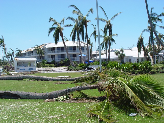
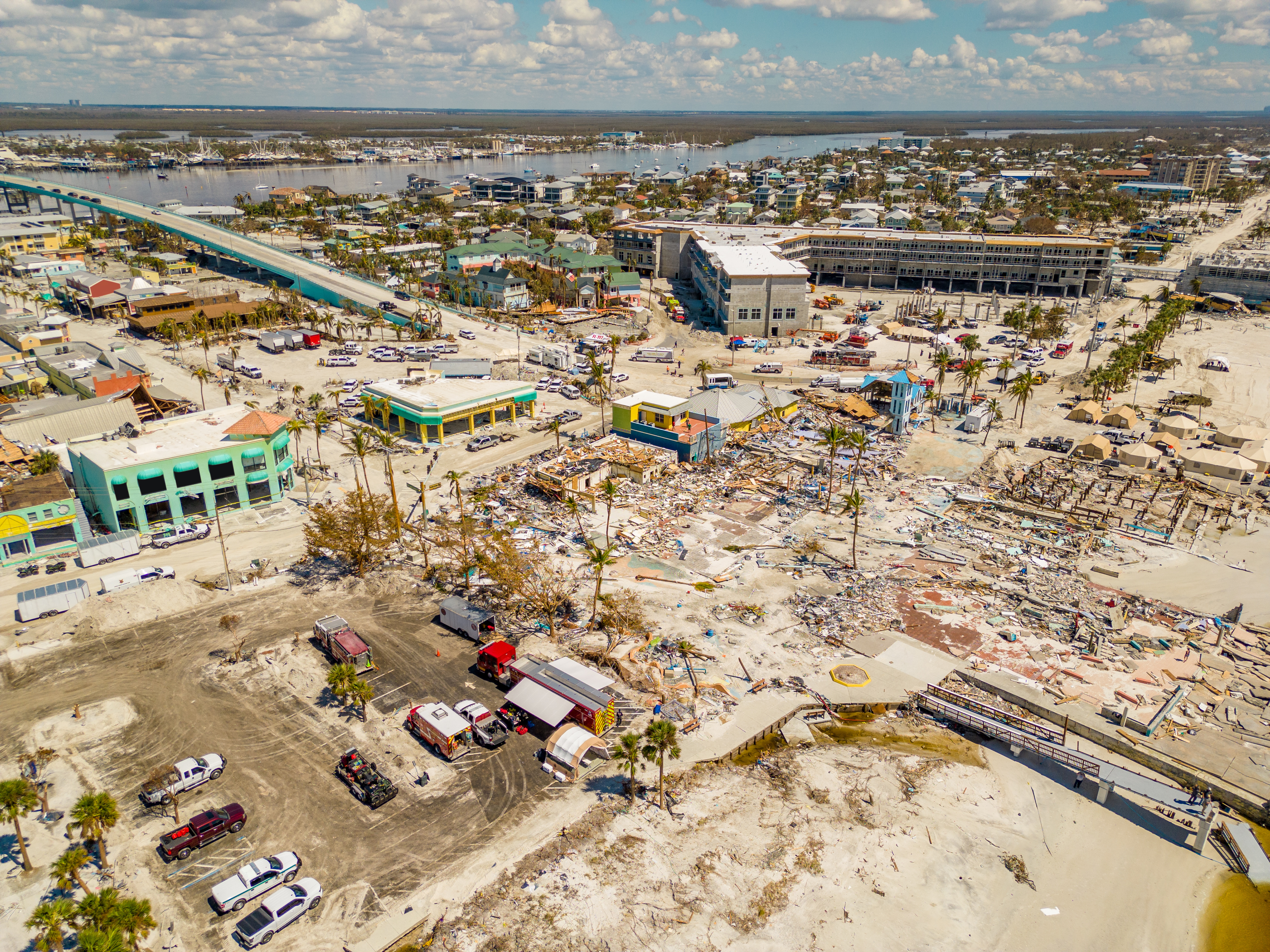
The difference between Ian (top) and Charley (bottom) is quite clear in terms of damage to waterfront coconut palms. Note that both images were taken in the paths of the strongest winds, at Fort Myers Beach and on Captiva Island, respectively. The first image clearly indicates that the wave-crests in Ian were well short of the coconut palms’ crowns, as debris-marks suggests. As I mentioned previously, the damage in the lower image would suggest sustained winds of ≥ 90 knots and gusts of ≥ 117 knots. While the first image does show severe damage to palms just inland from the shoreline, the latter palms are subject to wind-tunnelling, being sited behind various obstructions such as buildings.
 
Back
Top