
I haven’t gotten to dive into the model yet outside of reflectivity, been busy. what is the factor HRRR is seeing that’s tamped down on discrete cels?I'm not sold on these last few runs of less discrete. Maybe the next few hours or so will help things out. Hunch is that things will swing back in the other way how it was.
Navigation
Install the app
How to install the app on iOS
Follow along with the video below to see how to install our site as a web app on your home screen.
Note: This feature may not be available in some browsers.
More options
-
Welcome to TalkWeather! We see you lurking around TalkWeather! Take the extra step and join us today to view attachments, see less ads and maybe even join the discussion. CLICK TO JOIN TALKWEATHER
You are using an out of date browser. It may not display this or other websites correctly.
You should upgrade or use an alternative browser.
You should upgrade or use an alternative browser.
Severe WX March 23-25th, 2023
- Thread starter Lake Martin EF4
- Start date
I'm worried at this actually uptrending...
Models have been rather wonky. It would be unwise to follow a few model run, observations will be pretty important today.
Models have been rather wonky. It would be unwise to follow a few model run, observations will be pretty important today.
Not sure really, haven't looked but hunch tells me it'll swing back, it's done that with a few major events in recent memory where it shoots big, then goes blahhhh and then comes back up. It may not be as volatile as the 07z hrrr run but still.I haven’t gotten to dive into the model yet outside of reflectivity, been busy. what is the factor HRRR is seeing that’s tamped down on discrete cels?
With the HRRRs track run of being pretty bad at storm coverage from the last big event I'm hesitant on thinking there won't be more coverage than some of the conservative hrrr runs in the last few hours. But hey what do I know lol
Sun is out now in Smithville, MS. Current temp is 71 with a dewpoint of 67. Expected to get up to 85 today. You know it's bad when the Dewpoint and current temperature are nearly the same at nearly 9am.
tornado examiner
Member
will storms be explosive today or will they take some time to develop?
Regardless of the strong tornado possibility, keep in mind there is also a 30% hatch area for 70+mph winds.
Tanner
Member
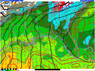
13z HRRR looks even less impressive from a convective standpoint. Slightly more linear. When is it safe to say we have a probable cause for distrust for these short range models ")
13z was a soup sandwich. I really thought this setup would be a good one. I’m starting to think it’s going to downtrend that way, HRRR is consistently showing a downtrend on each run now.13z HRRR looks even less impressive from a convective standpoint. Slightly more linear. When is it safe to say we have a probable cause for distrust for these short range models
Same thing on 12z NAM 3km
I just don’t understand what factor is causing them to back off at this hour
tornado examiner
Member
If I hear the word down-trend one more time! I’m gonna lose it! It’s obviously a great thing for the public
tornado examiner
Member
Lol. I’m kidding. But with things going back and fourth constantly it’s hard to know what to trust if anything
Tanner
Member
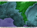
I think what will happen is that one storm will prevail in front of the line and really take advantage of the environment, as the 12z HRRR indicated that happening with one cell really popping off north of Monroe Louisiana and tracking all the way through northern Mississippi. Given some quick analysis, albeit degenerate, I stand on that hill.13z was a soup sandwich. I really thought this setup would be a good one. I’m starting to think it’s going to downtrend that way, HRRR is consistently showing a downtrend on each run now.
Same thing on 12z NAM 3km
tornado examiner
Member
Personally I don’t see the downtrends being accurate. If discrete storms don’t manage to form in that very broad, very open warm sector forming right now ima be very surprised
warneagle
Member
Ironically enough, that was what the earliest long-range CAMs showed: one dominant supercell on roughly that track with several smaller UH streaks across southern Arkansas and northern Mississippi. Not sure what the issue is further south.I think what will happen is that one storm will prevail in front of the line and really take advantage of the environment, as the 12z HRRR indicated that happening with one cell really popping off north of Monroe Louisiana and tracking all the way through northern Mississippi. Given some quick analysis, albeit degenerate, I stand on that hill.
Id follow the environment at this point not the back and forth hrrr. The environment is relatively unchanged as to what the hrrr predicted at 07z and now.....
TCLwx
Member
From the most recent JAN AFD. They don't seem to be backing off.
The near term forecast looks to be on track with the center of an upper ridge having moved east of our area this morning. An upper trough is analyzed west moving into the central and southern Plains this morning. By late afternoon and evening, this trough will be responsible for a likely severe weather event with the details in the previous discussion still aligned with current forecast thinking.
tornado examiner
Member
That’s bad, right?For the record, the current dewpoints are in the low 70s compared to what the 13z HRRR, 12z NAM, and 12z 3km NAM initialized at.
YepThat’s bad, right?