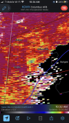
Another upgrade in tornado risk requires a moderateIt will be interesting to see what the next D1 update says in about 90 mins. I don’t think there will be an upgrade to MOD, but I would not be surprised to see another upgrade to tornado risk.
Thoughts?
Navigation
Install the app
How to install the app on iOS
Follow along with the video below to see how to install our site as a web app on your home screen.
Note: This feature may not be available in some browsers.
More options
-
Welcome to TalkWeather! We see you lurking around TalkWeather! Take the extra step and join us today to view attachments, see less ads and maybe even join the discussion. CLICK TO JOIN TALKWEATHER
You are using an out of date browser. It may not display this or other websites correctly.
You should upgrade or use an alternative browser.
You should upgrade or use an alternative browser.
Severe WX Severe Weather Threat Jan 12th, 2023
- Thread starter KevinH
- Start date
- Thread starter
- #322
KevinH
Member
Oh I know. I just think it’s freaking hilarious. Keep it up and don’t mind me!I'm not trying to I swear haha
A hatched area wouldn't be unreasonable considering the uptrending in model data.It will be interesting to see what the next D1 update says in about 90 mins. I don’t think there will be an upgrade to MOD, but I would not be surprised to see another upgrade to tornado risk.
Thoughts?
Timhsv
Member
Injuries' reported Hwy 20 in Morgan Co. along with over turned 18 wheelers and snapped trees near Pryor Field
Small Tornado Watch being considered ahead of the main storms that will affect North-Central and West-Central GA later today.
Mesoscale Discussion 0050
NWS Storm Prediction Center Norman OK
0913 AM CST Thu Jan 12 2023
Areas affected...southern TN...far northwest GA
Concerning...Severe potential...Watch possible
Valid 121513Z - 121615Z
Probability of Watch Issuance...60 percent
SUMMARY...A small tornado watch is being considered for southern TN
into far northwest GA as a squall line continues to move east
towards the area later this morning and into the midday hours.
DISCUSSION...Radar mosaic shows a squall line over southern middle
TN extending southwest into northern AL. Surface analysis shows
surface dewpoints in the upper 50s with temperatures into the mid
60s. KHTX VAD shows strong southwesterly mid-level flow (70 kt
around 6 km AGL) and forecast soundings show enlarged low-level
hodographs. Although buoyancy is seemingly the limiting ingredient,
forecast soundings show around 250 J/kg MLCAPE, likely adequate for
a continued risk for severe thunderstorms capable of damaging gusts
and perhaps a brief tornado or two.
..Smith/Guyer.. 01/12/2023
New AFD short-range disco. from FFC.
.UPDATE...
Issued at 1016 AM EST Thu Jan 12 2023
It is setting up to be a potentially active day across North and
Central GA. Wedge front across the northeast is gradually breaking
down as a developing storm system to our west continues to trek
eastward. Portions of southwest GA are already seeing dewpoints
in the low 60s as southerly/southwesterly flow gradually increases
ahead of an approaching storm system. Latest GOES satellite
imagery indicates portions of this same area are also seeing some
breaks in the clouds, which is not an ideal sign but from a
meteorological standpoint could contribute to a little bit better
instability further contributing to the development of severe
storms later this afternoon. Still looks like the primary hazards
will be strong damaging winds and some spin up tornadoes. Latest
12z FFC RAOB sounding indicates a sharp inversion at 850mb with a
good bit of dry air aloft. This has resulted in DCAPE around
600J/Kg. So certainly a potential for those winds aloft to mix
down to the surface resulting in strong to severe winds/wind
gusts. A Wind Advisory will remain in effect for the entire
forecast area from 11AM to 11PM with sustained winds of 15-20MPH
and gusts of 30-40MPH. This is in association with a strong
gradient developing ahead of the storm system. So definitely will
be a warm, breezy day today despite the severe weather potential
later this afternoon. Stay weather aware folks!
MattPetrulli
Member
I would be surprised to see them not upgrade to hatch. Soundings this morning have been quite impressive and it has been trending more discrete. Like what @andyhb said the 12z CAMs suite is quite impressive. Posting UH tracks to put it into simple termsIt will be interesting to see what the next D1 update says in about 90 mins. I don’t think there will be an upgrade to MOD, but I would not be surprised to see another upgrade to tornado risk.
Thoughts?


TDS with eutaw one?
Looks like a TDS in Sumter Co.
OHWX97
Member
Yes. Showing up on boh KGWX and KBMXTDS with eutaw one?
Equus
Member
Certainly been an interesting morning; had strong gusty winds and pea sized hail with the leading edge NW of Jasper. The segment that went tornado warned over Smith Lake passed overhead just before tightening and got to see low ragged clouds and a strong wind shift. One hour rainfall total at 0.54"
Gainesville Alabama about to be hit by a tornado
It’s passing to the south.Gainesville Alabama about to be hit by a tornado
- Moderator
- #340
From Morgan County 911:
THERE IS A LOT OF DAMAGE ON HIGHWAY 20 NEAR JAY'S LANDING - TO THE BELTLINE IN DECATUR.
AVOID THE AREA! TRAFFIC ON 20 FROM HIGHWAY 31 IS BEING DIVERTED SOUTH ON 12TH AVE NORTHWEST, TRAFFIC COMING FROM THE WEST IS BEING DIVERTED SOUTHBOUND ON THE BELTLINE
THERE IS A LOT OF DAMAGE ON HIGHWAY 20 NEAR JAY'S LANDING - TO THE BELTLINE IN DECATUR.
AVOID THE AREA! TRAFFIC ON 20 FROM HIGHWAY 31 IS BEING DIVERTED SOUTH ON 12TH AVE NORTHWEST, TRAFFIC COMING FROM THE WEST IS BEING DIVERTED SOUTHBOUND ON THE BELTLINE


