• Welcome to TalkWeather!
    We see you lurking around TalkWeather! Take the extra step and join us today to view attachments, see less ads and maybe even join the discussion.
    CLICK TO JOIN TALKWEATHER

Significant Tornado Events

There are aerial photos of most of the 5/31/85 outbreak area, but they haven't been digitized and they cost $30 each to order. There are like 270(?) in all, which is.. slightly outside my price range lol. I think the Cincy area is the only place that's really covered from 4/3/74. The photos are mostly from projects that have nothing to do with tornadoes so you just kinda have to get lucky finding areas that happened to be photographed at the right times.

Some of the 4/3/74 tracks are definitely visible in the old Landsat imagery (I posted some of the Alabama ones a while ago) and of course 5/31/85 is rather highly visible via satellite, but that's about it. I also checked the Worcester tornado out of curiosity, but the nearest photos were from a couple of years later and any remaining signs of the path are pretty subtle.

Another random thing I noticed: one of the aerial photo collections covers all of eastern South Dakota every year from like.. 1979 to 2005 or something? So I bet some of the more notable SD tornadoes (not that there have been a ton of them) show up in there. I think it's named the SD NRCS Collection or some such.

Probably Spencer and Manchester; any others?
 
So I found a few interesting new tidbits re: New Richmond from the area just northeast of Boardman, which is where the tornado reached its maximum size. Gonna copy/paste from my article bc I'm lazy:

Continuing through the gently rolling farmland north and east of Boardman, the powerful vortex gouged furrows into the earth. Its fierce winds pulled grass and crops from the ground, scouring the soil to a depth of several inches. The vast quantities of dirt and grit only amplified its destructive force, turning the seething mass into a giant sandblaster.

The tornado cut a swath nearly a mile wide as it swallowed up farm after farm, disintegrating dozens of houses, barns and outbuildings. Dead horses and cattle littered the countryside, many horribly disfigured, caked in mud and skinned by the abrasive blast. On one property, a Jersey cow was blown out of its barn and carried off into a ravine more than a thousand yards away. On another, a cast iron stove was propelled a quarter-mile into a field and “ripped apart.”
I've been trying for a long time to find more photos from this area because some of the people who saw the damage make it sound like it may have been even stronger here than in New Richmond itself - which is hard to believe considering New Richmond's about as bad as it gets. I'd read several accounts of significant scouring before, but I hadn't heard about the "furrows" it apparently dug. Don't have much in the way of descriptions, but it makes me think of something like Philadelphia or the 1/22/57 Gans, OK F4:

EcnqncO.jpg


0ijICEe.jpg


pN1xzQH.jpg


The cow being thrown a thousand yards is also something I only came across recently. Not exactly unprecedented, but not something you see all that often. I'm also trying to clear up a discrepancy with the death toll - in addition to the three official deaths in this area, several reports list either six or seven other fatalities (including three deaths each in two different families). I haven't been able to confirm or debunk them yet though. Luckily, most people in the area had either cellars or "storm caves" and saw/heard the tornado early enough to take shelter.

Edit: For reference, here's the area in question. The path should actually be quite a bit wider, especially immediately NE of Boardman, but I haven't gotten around to fixing it yet:

0ceyOHQ.png
 
So I found a few interesting new tidbits re: New Richmond from the area just northeast of Boardman, which is where the tornado reached its maximum size. Gonna copy/paste from my article bc I'm lazy:


I've been trying for a long time to find more photos from this area because some of the people who saw the damage make it sound like it may have been even stronger here than in New Richmond itself - which is hard to believe considering New Richmond's about as bad as it gets. I'd read several accounts of significant scouring before, but I hadn't heard about the "furrows" it apparently dug. Don't have much in the way of descriptions, but it makes me think of something like Philadelphia or the 1/22/57 Gans, OK F4:

EcnqncO.jpg


0ijICEe.jpg


pN1xzQH.jpg


The cow being thrown a thousand yards is also something I only came across recently. Not exactly unprecedented, but not something you see all that often. I'm also trying to clear up a discrepancy with the death toll - in addition to the three official deaths in this area, several reports list either six or seven other fatalities (including three deaths each in two different families). I haven't been able to confirm or debunk them yet though. Luckily, most people in the area had either cellars or "storm caves" and saw/heard the tornado early enough to take shelter.

Edit: For reference, here's the area in question. The path should actually be quite a bit wider, especially immediately NE of Boardman, but I haven't gotten around to fixing it yet:

0ceyOHQ.png
Though it would be very hard to estimate, I still want to ask if it's possible to have the speed of New Richmond tornado. Like whether it was extremely slow moving or not.
 
Though it would be very hard to estimate, I still want to ask if it's possible to have the speed of New Richmond tornado. Like whether it was extremely slow moving or not.
I'd always assumed it was before I really started researching it, but apparently quite the opposite. The first confirmed tornado in the family touched down around Catfish Bar (near Afton, MN) at either 5:30 or 5:40 - I've seen both but 5:40 makes more sense. The second tornado touched down around North Wisconsin Junction (now Northline) at approx. 5:52. It's well-attested that it then struck New Richmond right around 6:07, which is when multiple clocks stopped, including at the Omaha Depot train station.

So, accounting for some margin of error in timing + exact locations, that works out to between 36 and 48 mph. That also fits with survivor accounts, most of which describe the tornado as lasting no more than a few minutes and most of the damage occurring pretty suddenly.

Edit: Although I should say that I'm going from memory here, so my numbers may be a bit off. I'll double check my map later.
 
Last edited:
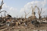
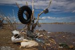
Here’s some rather impressive vegetation and contextual damage from the Greensburg tornado in various locations:
View attachment 16258
View attachment 16261
View attachment 16262View attachment 16263View attachment 16264
16283_32e0e6513a757b4d253d4d629477f5ba.jpeg

View attachment 16267
View attachment 16270
And here’s some vehicles that didn’t exactly fair too well.
View attachment 16268
View attachment 16269


Amazing how long it took to find EF5 damage pics from Greensburg, this thing was way more than a "minimal EF5" as previously thought. What's even more amazing is that this thing was weakening as it was going through town, which supports my belief that lots of EF4-5 tornadoes likely attain that intensity right until the very end.
 
What's even more amazing is that this thing was weakening as it was going through town, which supports my belief that lots of EF4-5 tornadoes likely attain that intensity right until the very end.
It really is surprising just how (relatively) common it is. I went through the (E)F5s I've mapped out so far and a majority of them produced violent-level damage within the last few miles of their tracks. The arrows point to the last known violent damage locations (at least that I'm aware of).

1893 Pomeroy, IA:

V1S94Y9.jpg


1899 New Richmond, WI:

8x2oeCc.jpg


1953 Worcester, MA (technically not an F5 of course, but should be):

nRqeCAp.jpg


1955 Udall, KS:

JoH57Nu.jpg


1957 Ruskin Heights, MO:

RXVgvH9.jpg


1958 Colfax, WI (path's still a WIP):

MGgPfM9.jpg


1966 Topeka, KS:

RuvXMHs.jpg


1974 Brandenburg, KY:

Is8XWRt.jpg


1985 Niles, OH-Wheatland, PA:

f4zGS67.jpg


1999 Bridge Creek-Moore, OK:

YKncQCq.jpg


2013 Moore, OK:

QIcwT9G.jpg
 
Amazing how long it took to find EF5 damage pics from Greensburg, this thing was way more than a "minimal EF5" as previously thought. What's even more amazing is that this thing was weakening as it was going through town, which supports my belief that lots of EF4-5 tornadoes likely attain that intensity right until the very end.
I’ve got roughly 600 damage photos from this tornado and am hoping to make some sort of album to share for research purposes or just for viewing, but yeah it did take some very deep digging to find out it definitely was not minimal lol. The tornado almost certainly peaked south of town, likely around Highway 183 where this happened:
10B67BC9-D7D9-4BC4-A154-FC23A9751AEF.jpeg
A83D8EC9-A411-4DA9-9185-DD5988972D5C.jpeg
33EE41C4-4DD7-4A7E-BA7A-7647C5117224.jpeg
The tornado remained extremely violent up until just north of the lake which was about 2 miles where the damage becomes almost non existent. It’s also very likely the tornado hit a secondary peak in northern neighborhoods in Greensburg and around the lake, not long before dissipating. Literally every tree and shrub in that area was shredded and 100% debarked. That’s also where that church and numerous homes were swept away.
140FD326-A25B-4913-9300-E1C281CCEE15.jpeg
63D452BA-6466-4B41-8AD2-C9BE2FE7B65F.jpeg
8292B95E-D137-4767-9FB0-2B060DA80ED5.jpeg
9801BE18-2979-47B3-A7CA-99D0C23B32C5.jpeg
9E783230-75B0-4971-B405-46A886A3479F.jpeg
239AC8F1-076D-4F21-BB20-FCE240485309.jpeg
Had to throw in this picture again just because it gets even more insane every time I look at it. This was also near the very end of the track and yet it was still able to do this level of tree and vegetation damage.
340AFC5A-87BE-415B-B0BE-CD55287EDF28.jpeg
 
I’ve got roughly 600 damage photos from this tornado and am hoping to make some sort of album to share for research purposes or just for viewing, but yeah it did take some very deep digging to find out it definitely was not minimal lol. The tornado almost certainly peaked south of town, likely around Highway 183 where this happened:
View attachment 16276
View attachment 16277
View attachment 16279
The tornado remained extremely violent up until just north of the lake which was about 2 miles where the damage becomes almost non existent. It’s also very likely the tornado hit a secondary peak in northern neighborhoods in Greensburg and around the lake, not long before dissipating. Literally every tree and shrub in that area was shredded and 100% debarked. That’s also where that church and numerous homes were swept away.
View attachment 16280
View attachment 16281
View attachment 16282
View attachment 16283
View attachment 16284
View attachment 16285
Had to throw in this picture again just because it gets even more insane every time I look at it. This was also near the very end of the track and yet it was still able to do this level of tree and vegetation damage.
View attachment 16286

Is that pic near Highway 13 the one with the automobile rolled into a ball? Hard to tell with the quality of the pic.
Also, there's that crazy pic of the bent rail tracks from Greensburg. One of the few tornadoes I know of to have done that.
Don't forget the 2+ mile Trousdale wedge that occurred right after it. I know it was rated EF3 but it undoubtedly had EF5 potential had it hit populated areas. Do you have any damage pics of Greensburg's path across the plains before it hit town? Did it much scouring or vegetation/tree damage in open country?
 
It really is surprising just how (relatively) common it is. I went through the (E)F5s I've mapped out so far and a majority of them produced violent-level damage within the last few miles of their tracks. The arrows point to the last known violent damage locations (at least that I'm aware of).

1893 Pomeroy, IA:

V1S94Y9.jpg


1899 New Richmond, WI:

8x2oeCc.jpg


1953 Worcester, MA (technically not an F5 of course, but should be):

nRqeCAp.jpg


1955 Udall, KS:

JoH57Nu.jpg


1957 Ruskin Heights, MO:

RXVgvH9.jpg


1958 Colfax, WI (path's still a WIP):

MGgPfM9.jpg


1966 Topeka, KS:

RuvXMHs.jpg


1974 Brandenburg, KY:

Is8XWRt.jpg


1985 Niles, OH-Wheatland, PA:

f4zGS67.jpg


1999 Bridge Creek-Moore, OK:

YKncQCq.jpg


2013 Moore, OK:

QIcwT9G.jpg

I think most tornadoes likely achieve their peak intensity throughout most of their lives, whether or not they hit DIs capable of registering it is another deal. Another interesting detail is that the areas of peak intensity for quite a bit of these tornadoes were also when they were at their widest. I know it might be a coincidence but just something of note. Niles-Wheatland in particular is remarkable due to how narrow most of its path is then it hulks out to half a mile while going through Wheatland then abruptly narrows almost as soon as it exits the city. Like it had a grudge against it or something.
Also, whats up with Moore 2013 abruptly narrowing halfway through the city before widening again?
 
Is that pic near Highway 13 the one with the automobile rolled into a ball? Hard to tell with the quality of the pic.
Also, there's that crazy pic of the bent rail tracks from Greensburg. One of the few tornadoes I know of to have done that.
Don't forget the 2+ mile Trousdale wedge that occurred right after it. I know it was rated EF3 but it undoubtedly had EF5 potential had it hit populated areas. Do you have any damage pics of Greensburg's path across the plains before it hit town? Did it much scouring or vegetation/tree damage in open country?
Yes that is the same one, and here’s the bent railroad tracks picture.
6F6AD05E-9FEE-43DD-ABC5-CF4DF07B88AE.jpeg
From what I could make out from it that large farm implement which originated from the BTI John Deere company (which btw was around 1400 feet south of the train tracks) likely slammed into the tracks. Someone actually walked along the train tracks and photographed the damage and some of them are pretty impressive.
I’ve also got several pictures of Trousdale/Hopewell/Macksville and both Trousdale and Hopewell were likely EF5.
Here’s the damage pictures I’ve got from south of town, I really wish more images were taken near the center of the tornado like the other 3 I shared were but there definitely is a lack of photos south of town.
89BAA56D-792E-422B-852B-AF450146A818.jpeg
98C72E24-B7ED-4012-8622-EA819647C678.jpeg
274A7233-0455-4CE9-9FB5-4B36B393CD5B.jpeg
2B264BA3-EBEE-48F2-BD48-F2CB19C3A000.jpeg
11656078-928A-416D-95E8-68D89249E403.jpeg
6C43C782-5FB4-4C62-A65F-532AD4E7176A.jpeg
4F57F458-3AF9-4B2E-8E8D-7A2AF2FD2A02.jpeg
3C94876F-8A64-4955-AFDF-70EE7278A789.jpeg
I’m sure if I spent some more time really digging I could come up with a few more but they’re extremely hard to come by. I know that in the image of the crumpled up car there is some ground scouring clearly visible and I remember a chaser who drove through the path on Highway 183 pointed out that “even the grass is gone” but the video quality was horrible and it was tough to make out much. But from what I’ve heard and seen ground scouring did occur along the highway and also google earth imagery shows some pretty intense tree and vegetation damage south of town as well.

Also, speaking of that BTI John Deere company this picture always cracks me up of a giant combine tire wedged into a debarked tree by the lake, roughly 1/2 mile north of the company.
837D6B1A-61F6-48A3-9821-0A011AA6533A.jpeg
 
Last edited:
I think most tornadoes likely achieve their peak intensity throughout most of their lives, whether or not they hit DIs capable of registering it is another deal. Another interesting detail is that the areas of peak intensity for quite a bit of these tornadoes were also when they were at their widest. I know it might be a coincidence but just something of note. Niles-Wheatland in particular is remarkable due to how narrow most of its path is then it hulks out to half a mile while going through Wheatland then abruptly narrows almost as soon as it exits the city. Like it had a grudge against it or something.
Also, whats up with Moore 2013 abruptly narrowing halfway through the city before widening again?
Moore underwent a failed occlusion around Moore Medical Center and did a whole loop over the 7/11 and narrowed significantly in that area. Video footage you can see right after it destroys Plaza Towers it becomes completely wrapped in rain/debris and it’s pretty incredible it’s like the updraft that was suspending the massive amount of debris momentarily weakened and a whole load of debris rained down across I-35 and several businesses in the area, there was a video out there that showed just how littered the area was I’ll have to find it. But yeah around Moore Medical Center it became completely obscured before crossing I-35 and becoming less rain-wrapped.
 
Found another interesting damage feat from the Greensburg tornado, and is the most impressive vehicle damage I’ve heard or seen from the event.
549BDEB8-5102-40AF-A7DB-A1AB948BA353.jpeg
06081057-29C9-4934-AEB1-1BC3A6F02C43.jpeg
This random hunk of mangled metal would be the remains of a pickup truck that originated from a home just south of town. It was launched an entire mile across a field, torn in half, and the front end which is pictured above, landed in some dudes living room…lol. Here’s the original video this was taken from, skip to around 0:56 to hear the owners story, it’s pretty remarkable.
 
Don't forget the 2+ mile Trousdale wedge that occurred right after it. I know it was rated EF3 but it undoubtedly had EF5 potential had it hit populated areas.
Would love to see some of the photos @Western_KS_Wx has from the other Greensburg family tornadoes, but based on the few photos I have from Trousdale, it was definitely an EF5.
Trousdale-EF5-damage-debarking.JPG
Trousdale-EF5-damage-home.JPG
Trousdale-EF5-damage-home2.JPG
 
I’ve got roughly 600 damage photos from this tornado and am hoping to make some sort of album to share for research purposes or just for viewing, but yeah it did take some very deep digging to find out it definitely was not minimal lol. The tornado almost certainly peaked south of town, likely around Highway 183 where this happened:
View attachment 16276
View attachment 16277
View attachment 16279
The tornado remained extremely violent up until just north of the lake which was about 2 miles where the damage becomes almost non existent. It’s also very likely the tornado hit a secondary peak in northern neighborhoods in Greensburg and around the lake, not long before dissipating. Literally every tree and shrub in that area was shredded and 100% debarked. That’s also where that church and numerous homes were swept away.
View attachment 16280
View attachment 16281
View attachment 16282
View attachment 16283
View attachment 16284
View attachment 16285
Had to throw in this picture again just because it gets even more insane every time I look at it. This was also near the very end of the track and yet it was still able to do this level of tree and vegetation damage.
View attachment 16286
One of the argument I alway saw with Greensburg being marginal EF5 tornado at best was there were lots of houses still relatively intact in its path and this argument was really untenable to me. For any cyclone, It take much higher winds to do the same damage with larger RMW which is part of the reason why tropical cyclone would never really swept the whole community clean with winds alone even for those strongest ones. The theory actually have paper back up with. Most violent tornados tend to have a narrow core with RMW no more than 50-100m. Greensburg had the widest EF4 swath since the implement of EF scale and it would take insanely high winds to swept all houses within the path which apparently no tornado can do. (also you can tell why joplin was insane from this.)When Greensburg was narrower noth side of the town, houses immediately all swept away. This perhaps not due to abrupt strengthen around this place but the change of vortex's structure. Marshall said Greensburg was one the strongest he ever surveyed and I think he's being right this time.
 
Last edited:
Back
Top