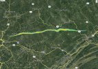
We've talked before about tornadoes with really tiny violent cores, and I think this photo from Evans City is a pretty cool illustration of that. You can see along the left edge where the tornado just went ham on a little grove of trees and then continued on across the field and over the hill. That tiny little section of completely demolished trees is like 30-ish yards wide. About 100 yards to the left of there was a house that only suffered like F1-F2 damage at most. And yet there was a business along the road below there that was totally leveled and a full-sized van was thrown up and over the other side of the hill in the center of the picture.
In the article I think I said the van was thrown (presumably, at least - no one could find any obvious impact/bounce marks) half a mile into a house, but it's actually a shade over six-tenths of a mile depending on
exactly where the van was parked.