- Moderator
- #1
SPC has a Day 3 enhanced risk out for Eastern OK and North TX region.
Follow along with the video below to see how to install our site as a web app on your home screen.
Note: This feature may not be available in some browsers.

SPC AC 090645
Day 2 Convective Outlook CORR 1
NWS Storm Prediction Center Norman OK
0145 AM CDT Sat Oct 09 2021
Valid 101200Z - 111200Z
...THERE IS AN ENHANCED RISK OF SEVERE THUNDERSTORMS ACROSS MUCH OF
CENTRAL AND EASTERN OKLAHOMA...AND ADJACENT NORTH TEXAS...
CORRECTED FOR THUNDER LINE COLOR OVER FLORIDA
...SUMMARY...
Strong/severe storms are forecast from Sunday afternoon onward
across portions of the southern Plains and vicinity, with large
hail, damaging winds, and a few tornadoes possible.
...Synopsis...
As a large-scale northern-stream trough digs quickly southeastward
out of western Canada into/across the northwestern states, a lead
trough -- comprised of discrete northern- and southern-stream
features -- will eject eastward/east-northeastward across the
central U.S. through the period. Specifically, the northern-stream
low will shift northeastward across Minnesota and into western
Ontario late. Meanwhile, the southern-stream trough will move
quickly out of the Four Corners states into the central/southern
High Plains by afternoon, and then will continue east-northeastward
-- taking on slight negative tilt with time -- as it reaches eastern
Kansas/eastern Oklahoma/East Texas by the end of the period.
At the surface, a cold front will shift southeastward across the
Intermountain West ahead of the digging western upper trough.
Meanwhile, a cold front will move gradually across the Upper
Mississippi/mid Missouri/Kansas and the southern High Plains through
the afternoon. A frontal wave is progged to develop by late
afternoon over western North Texas/southwestern Oklahoma, and then
shift quickly northeastward into Missouri overnight, as the trailing
cold front sweeps quickly southeastward across the southern Plains
through the end of the period.
...Eastern portions of Oklahoma/Texas and vicinity...
As an fairly potent mid-level short-wave trough moves into the
southern Plains region during the afternoon, focused ascent along
the sharpening cold front should result in frontal cyclogenesis in
the north Texas/southwestern Oklahoma vicinity. Daytime heating of
a capped warm-sector, beneath steep lapse rates aloft, will result
in moderate destabilization, with 1000 to 2000 J/kg mixed-layer CAPE
expected across central Oklahoma and southward into Texas by late
afternoon.
At this time, it appears that initial surface-based storm
development will occur in the western North Texas/southwestern
Oklahoma area, during the late afternoon time frame. With
increasingly strong mid-level flow overspreading increasingly strong
low-level south-southwesterlies, and boundary-layer flow backed to
south-southeasterly ahead of the evolving surface low, shear
favorable for supercells, including low-level rotation, suggests
risk for large hail, damaging winds, and -- for the first few hours
of the event -- a few tornadoes, as storms move northeastward into
the central third of Oklahoma and adjacent North Texas.
With time, upscale growth is expected to result in a semi-broken to
continuous line of storms, spreading eastward from southern Kansas
southward into northern/central Texas. Strong/veering flow with
height suggests rotating updrafts will remain possible within the
line, and so a tornado or two will remain possible well into the
evening. Gradually though, risk will trend toward mainly damaging
winds, as the storms eventually reach Missouri/Arkansas/east Texas
through the end of the period.
...Upper Mississippi Valley/western Upper Great Lakes region...
Scattered/ongoing showers and thunderstorms may pose risk for hail
early in the period, with some chance for local instances of hail
near severe levels. Storms will largely spread northeastward across
northern Minnesota and Lake Superior and into Canada through the
day, but isolated, low-topped storm redevelopment -- fueled by
modest heating beneath cool mid-level temperatures -- may occur
during the afternoon. Again, storms could locally pose a risk for
hail, possibly near severe levels in conjunction with a couple of
the strongest updrafts, but at this time coverage of storms appears
likely to remain limited, and thus will maintain only MRGL risk
across this area, through early evening.
..Goss.. 10/09/2021
CLICK TO GET WUUS02 PTSDY2 PRODUCT
NOTE: THE NEXT DAY 2 OUTLOOK IS SCHEDULED BY 1730Z
CURRENT UTC TIME: 1554Z (10:54AM), RELOAD THIS PAGE TO UPDATE THE TIME


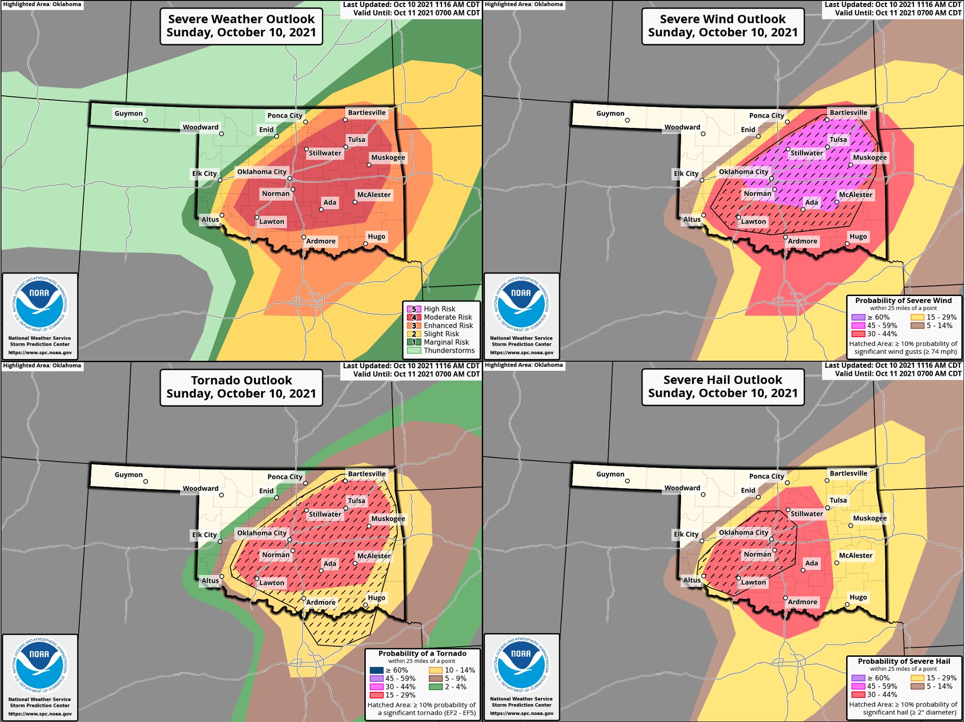
 I’m on mobile right now so i don’t know if this will show up right but there is now a moderate risk out with a 15% hatched tornado risk in Oklahoma and a 10% hatched that extends even down into north Texas. This does include the OKC metro and north parts of DFW unfortunately.
Also, this has been the case for a while, but HRRR's UH is not terribly reassuring.
Reminds me of what 5/20/19 looked likeAlso, this has been the case for a while, but HRRR's UH is not terribly reassuring.
View attachment 10475


Tornado Watch 517 is out. 90/70 tornado probabilities. How is this not a PDS watch?
For some reason the NAM model tends to really go overboard. However I also think the GFS model is underestimating it today.I think that sounding is contaminated? That's usually the case when you get the crazy vertical velocities in a saturated profile right?
I think it's just a problem for the non-convection-allowing models since they can't natively resolve the convection? I don't know, I know absolutely nothing about how the models work under the hood.For some reason the NAM model tends to really go overboard. However I also think the GFS model is underestimating it today.