• Welcome to TalkWeather!
    We see you lurking around TalkWeather! Take the extra step and join us today to view attachments, see less ads and maybe even join the discussion.
    CLICK TO JOIN TALKWEATHER
  • April 2024 Weather Video of the Month
    Post your nominations now!
Logo 468x120

locomusic01

Member
Messages
1,361
Reaction score
3,796
Location
Pennsylvania
Hard to say without photos. Buildings with a lot of surface area and a lack of interior walls, particularly lightweight metal ones, can kind of act like a sail and catch the wind, creating a very powerful upward "wrenching" force that will put enormous stress on whatever beams are supporting the structure, twisting, pulling, or buckling them in a way that looks very impressive. While the presence of snapped anchor bolts definitely raises and eyebrow, given the type of building type described, I wouldn't necessarily say that this is clear evidence of a violent-tier tornado. Not to say there was no evidence of F4 damage elsewhere along the Beaver Falls tornado's path, however.
Sure, that's almost certainly what happened given how far it was carried. I wouldn't include it among the possible instances of violent damage without knowing more; just an example of something that turned out to be a lot more impressive than I thought.

On the opposite end of the spectrum, a few of the houses that were allegedly "destroyed" or even "swept away" ended up being nothing of the sort in reality. In one case, I talked to a guy whose home near Evans City was supposed to have been torn from its foundation and scattered across a field. It all sounded pretty impressive until he told me the house was basically sitting on cinder blocks and got pushed out across his backyard. The only thing that was "scattered" was a porch/deck that broke apart.

Incidentally, another house just down the street from that one is among the damage points I consider potentially violent. Haven't got the photos yet, but by the owner's description it sounds like it was reasonably well-built, and it was completely flattened/partially swept away. A van that was in the parking lot was apparently tossed a quarter-mile and crushed, and there may have been some scouring and debarking on/around the property.
 
Messages
2,235
Reaction score
2,827
Location
Missouri
Horton, KS was 4/12/11:

1911-apr-12-horton-ks-f3-home-2.jpg


1911-apr-12-horton-ks-f3-home-wrecked.jpg


1911-apr-12-horton-ks-f3.jpg


horton-ks-robertson-place.jpg


It struck as part of a localized outbreak that also featured an F4 in Barnsdall, OK (known as Bigheart at the time):

metadc1592929-xl-21884-1-27.jpg


metadc1594281-xl-21884-1-25.jpg


metadc1594376-xl-21884-1-29.jpg


metadc1596130-xl-21884-1-24.jpg


metadc1596140-xl-21884-1-26.jpg


metadc1596263-xl-21884-1-28.jpg


There was also an F3 that cut through parts of OK, KS and MO, ending north of Joplin. A few people were injured on this property in Cherokee Co, KS:

1911-apr-12-cherokee-co-ks.jpg


There was also an F2 in Lawrence, KS:

lawrence-ks-2.jpg


lawrence-ks-paper-mill.jpg


lawrence-ks.jpg


And another F2 in Eskridge, KS:

residence-and-church.jpg


kasson-residence.jpg


eskridge-christian-church.jpg


covenanter-church.jpg


another-residence.jpg


bush-residence.jpg
"There was also an F3 that cut through parts of OK, KS and MO, ending north of Joplin. A few people were injured on this property in Cherokee Co, KS:"

So, another Tri-State Tornado? That's interesting, yeah I'm sure it wasn't anywhere in magnitude or path length but an interesting oddity nonetheless.
 

TH2002

Member
Sustaining Member
Messages
3,282
Reaction score
5,117
Location
California, United States
Special Affiliations
  1. SKYWARN® Volunteer
(Incidentally, a consequence of this is that cards often contain only vague information since they were usually being sent to people who already understood the context. Kind of the early 20th century version of posting a damage photo on social media with a caption like "check out the damage to our house!" or whatever without identifying exactly when or where it was taken.)
One example is this photo of tornado damage in Iowa:
s-l1600.jpg

It was taken in 1909 and the back says Villisca, but Grazulis has no mention of any tornadoes in Villisca in 1909. After putting all the pieces together this is most likely the July 11, 1909 Washta IA F2 (the card was postmarked in Villisca on July 12)
 
Messages
2,235
Reaction score
2,827
Location
Missouri
Yes, generally 35-45 mph with a few moving 50+. For example, I used the reported times on stopped clocks to work out the speed of the Wheatland tornado between various points (with some margin of error for incorrect time settings, etc):

Newton Falls -> Lordstown: ~39 mph
Lordstown -> Niles: ~38 mph
Niles -> Wheatland: ~43 mph

Using the official times for touchdown and dissipation (7:30-8:35) + the total path length (47 miles), the average speed is ~43 mph. That might be slightly fast, though. My own total path length is closer to 44 miles, which would be ~41 mph. The start and end times are a little bit fuzzy, but somewhere in the neighborhood of 40 mph is probably about right.

The Hubbard/Masury area was hit very hard, particularly in the short stretch where two people were killed. Most of the homes there weren't built well enough to justify a really high-end rating, but given some of the context, I suspect it was probably still capable of F5 damage. A row of homes on the south side of one road were totally obliterated with vehicles thrown hundreds of yards, etc. Kermont Heights got a lot of attention after the tornado, and it definitely suffered a lot of damage, but from what I've seen a lot of the homes in that neighborhood were sliders and probably wouldn't support a strong/violent rating today.

This photo was taken at about the time the tornado was doing its most intense damage in the Hubbard area - interesting to see what appears to be some horizontal vortices. Kinda reminds me of Henryville:

taken-at-7-06pm-tornado-near-warner-rd-and-chestnut-ridge-rd-Eagle-Joint-Fire-Department.jpg

Given its long time and path length, was Moshannon State Forest likely moving somewhere in the 50 mph range? It seems like that supercell was the most impressive of all that day, given how massive and powerful some of the tornadoes it spawned were, then again I suppose that's pretty relative given how violent the whole day was.
 

locomusic01

Member
Messages
1,361
Reaction score
3,796
Location
Pennsylvania
Given its long time and path length, was Moshannon State Forest likely moving somewhere in the 50 mph range? It seems like that supercell was the most impressive of all that day, given how massive and powerful some of the tornadoes it spawned were, then again I suppose that's pretty relative given how violent the whole day was.
Yeah, right around there. I wasn't able to pin down exact start and end times since both occurred out in the boonies, but the official figures have it on the ground for 85 minutes, which seems about right. At 69 miles, that's an average speed of ~49 mph. I'd imagine the speed was pretty variable though considering how it ping-ponged its way through the more rugged sections of terrain.

Incidentally, the next tornado (Bastress/Hidden Creek) appears to have been one of the slowest movers of the day, maybe only half that speed if the official start/end times are accurate. I'm a bit skeptical that they are, but several people did attest that it lasted a number of minutes when it hit. Many of the others passed in no more than 30-60 seconds.
 

locomusic01

Member
Messages
1,361
Reaction score
3,796
Location
Pennsylvania
I didn't think it was possible to do too much research, but.. I think I might have a problem lol. I feel like I've been really aggressive in cutting things out of my article, but my Beaver Falls section alone is now just shy of 3,000 words. Oh, and I've only covered about half of the path. Some of the tornadoes will be much shorter since there's not really a lot to cover, but that's still not an auspicious sign.

At some point, I might need to have somebody give me some feedback. I hate leaving stories/details out, but I'm not sure a 50,000 word article is very appealing to normal people.
 
Messages
2,235
Reaction score
2,827
Location
Missouri
Yeah, right around there. I wasn't able to pin down exact start and end times since both occurred out in the boonies, but the official figures have it on the ground for 85 minutes, which seems about right. At 69 miles, that's an average speed of ~49 mph. I'd imagine the speed was pretty variable though considering how it ping-ponged its way through the more rugged sections of terrain.

Incidentally, the next tornado (Bastress/Hidden Creek) appears to have been one of the slowest movers of the day, maybe only half that speed if the official start/end times are accurate. I'm a bit skeptical that they are, but several people did attest that it lasted a number of minutes when it hit. Many of the others passed in no more than 30-60 seconds.
Is this the wedge that occurred shortly after Moshannon State Forest lifted? If so, did that supercell spawn several massive wedges or just two?
 
Messages
2,235
Reaction score
2,827
Location
Missouri
I was doing some very in-depth digging on newspapers.com and came across this photo of destruction from a tornado at Aberdeen, MS on April 20th, 1920. Very impressive damage.

View attachment 9841
Have you been able to find any other damage photographs from this outbreak? This outbreak is more poorly-documented than 3/21/32. Also, is that extreme ground scouring I'm looking at? I can't tell from the poor quality of the picture (although I imagine that's a product of poor scanning then the photographer's).
 

locomusic01

Member
Messages
1,361
Reaction score
3,796
Location
Pennsylvania
Is this the wedge that occurred shortly after Moshannon State Forest lifted? If so, did that supercell spawn several massive wedges or just two?
Yeah, up to 1.5 miles wide at times. The supercell also went on to produce a final tornado in Luzerne County that was up to a quarter-mile wide, although it wasn't particularly strong. Weird thing there is that the NWS surveyed it at the time, literally noted that there was a "clear rotational pattern" to the damage and that the radar appeared to show signs of rotation, and then.. announced that it was a strong downburst. Very curious how the thought process went on that one lol

It's officially listed as an F1 in Storm Data. It sounds like some of the tree damage might've been fairly intense, but the structural damage was mostly confined to a mobile home park and a campground. Several trailers were rolled/thrown and a couple of people were injured.
 
Messages
2,235
Reaction score
2,827
Location
Missouri
Yeah, up to 1.5 miles wide at times. The supercell also went on to produce a final tornado in Luzerne County that was up to a quarter-mile wide, although it wasn't particularly strong. Weird thing there is that the NWS surveyed it at the time, literally noted that there was a "clear rotational pattern" to the damage and that the radar appeared to show signs of rotation, and then.. announced that it was a strong downburst. Very curious how the thought process went on that one lol

It's officially listed as an F1 in Storm Data. It sounds like some of the tree damage might've been fairly intense, but the structural damage was mostly confined to a mobile home park and a campground. Several trailers were rolled/thrown and a couple of people were injured.
It sort of reminds me of the Greensburg supercell, albeit less fatalities and the last tornado wasn't as wide.
 
Messages
2,235
Reaction score
2,827
Location
Missouri
Yeah, right around there. I wasn't able to pin down exact start and end times since both occurred out in the boonies, but the official figures have it on the ground for 85 minutes, which seems about right. At 69 miles, that's an average speed of ~49 mph. I'd imagine the speed was pretty variable though considering how it ping-ponged its way through the more rugged sections of terrain.

Incidentally, the next tornado (Bastress/Hidden Creek) appears to have been one of the slowest movers of the day, maybe only half that speed if the official start/end times are accurate. I'm a bit skeptical that they are, but several people did attest that it lasted a number of minutes when it hit. Many of the others passed in no more than 30-60 seconds.
So when tornadoes encounter complex terrain like hills, mountains, valleys, gorges, crevasses, etc. do they not just go straight over them? Does it make them change direction quite a bit? What would happen if a tornado encountered something like a canyon, would it simply cross it or would its circulation extend all the way down into the canyon until it moved forward on its way? Not sure how else to phrase that question.
Also, what's the source of the myth that tornadoes can't cross hills, mountains, valleys, etc. and only can go across wide, flat expanses of land? Is it because of the prevalence of the Great Plains as "Tornado Alley" in pop culture or is there more to it than that?
 

locomusic01

Member
Messages
1,361
Reaction score
3,796
Location
Pennsylvania
So when tornadoes encounter complex terrain like hills, mountains, valleys, gorges, crevasses, etc. do they not just go straight over them? Does it make them change direction quite a bit? What would happen if a tornado encountered something like a canyon, would it simply cross it or would its circulation extend all the way down into the canyon until it moved forward on its way? Not sure how else to phrase that question.
Also, what's the source of the myth that tornadoes can't cross hills, mountains, valleys, etc. and only can go across wide, flat expanses of land? Is it because of the prevalence of the Great Plains as "Tornado Alley" in pop culture or is there more to it than that?
Depends on a whole bunch of factors (the terrain itself, its surface roughness, the internal structure of the tornado, angle/speed of approach, etc). Sometimes there doesn't seem to be much of an effect and other times there can be significant changes in direction and/or intensity. One of the things that makes this outbreak so interesting is how many of the tornadoes encountered really varied terrain features.

For example, I've mentioned before the Moshannon tornado sort of expanding and deflecting to the north when it encountered the steep banks of the Susquehanna River south of Keating. The Beaver Falls tornado is another interesting case. It had expanded to nearly a quarter-mile wide as it approached the Big Beaver Plaza and didn't seem to show any clear multivortex traits, but just behind the plaza was a 300-foot ravine surrounding the Beaver River. The tornado had been traveling sort of SE/ESE at the time, but it wobbled more toward E/ENE briefly as it encountered the ravine. At the same time, it also contracted and became clearly multivortex. Once it started passing over the relatively flatter land of North Sewickley it resumed its more SE/ESE movement.

One of the neat things is that someone actually got a picture of it just as it was emerging from the ravine into North Sewickley, and even with just a still photo you can see a pretty striking transformation:

tornado-moving-from-big-beaver-to-north-sewickley-taken-from-beaver-falls-near-eastvale-bridge-ed-po.jpg


This was taken from two miles to the south (the bridge in the photo is the Eastvale Bridge). Another photo taken several minutes earlier shows a very classic cone shape, but then the structure clearly changes. Talking to a few of the people who saw it around this area, their descriptions remind me a lot of the famous shapeshifting Cullman videos from 4/27.

And yeah, I think that myth is mostly just because Plains twisters are what everyone pictures when they think about tornadoes. Tornadoes in mountainous/forested areas are a lot harder to photograph (or even see at all), and that kind of terrain just mostly happens to be confined to areas where atmospheric conditions are less favorable. There are obvious exceptions (mostly parts of the southeast), but those also tend to be places where fewer people live and where tornadoes wouldn't have made as much news in the past.

There have been some studies suggesting terrain might actually be a factor in tornado formation (Arkansas is an interesting subject here because there's such a clear divide between terrain types) but clearly it's nothing that can't be overcome in the right conditions.
 

locomusic01

Member
Messages
1,361
Reaction score
3,796
Location
Pennsylvania
I'm sure some of you probably remember the conversion van that was picked up off I-79 and thrown by the Beaver Falls tornado. There's always been confusion about that because the man and his wife estimated that it landed a mile away while Grazulis says a quarter-mile. Initially, it seemed like Grazulis' figure was about right. After talking to them and working with someone who lives in the area (along w/the help of Google Earth), I think I've pretty much nailed down where the van was picked up and where it landed. Turns out it was thrown between four-tenths and half a mile, depending on the exact spot where it was picked up from I-79.

Kinda interesting that the tornado was traveling roughly SE at the time and the van was spit out pretty close to due north.
 

TH2002

Member
Sustaining Member
Messages
3,282
Reaction score
5,117
Location
California, United States
Special Affiliations
  1. SKYWARN® Volunteer
That 3rd pic...whatever that vehicle was, it's completely pancaked. As flat as I've seen an automobile after a tornado.
Possibly a school bus similar to this one?
iu

If so... wow. The body would have effectively had to have been ripped from the frame in Rainsville fashion with the body itself torn to multiple pieces.
 
Messages
2,235
Reaction score
2,827
Location
Missouri
Possibly a school bus similar to this one?
iu

If so... wow. The body would have effectively had to have been ripped from the frame in Rainsville fashion with the body itself torn to multiple pieces.
It's a school bus, if you look at the bottom of the picture and turn your head upside down you can see the words "school" and "bus" partly hidden by bent metal.
 
Messages
2,235
Reaction score
2,827
Location
Missouri
Several of the tornadoes produced some really impressive contextual damage, although I don't wanna give everything away already lol. I don't think it's possible to infer that kind of extreme intensity just from that, though. The thing about Niles-Wheatland is that, even though the total damage path sometimes extended for half a mile or more, the core of it was only like 50-100 yards wide. Sometimes even narrower. But inside that tiny little core it was super violent.

Regarding scouring, soil differences are definitely huge. I dunno about all of PA, but most of the places I've lived in this state have had more clay-ish soil that tends to be quite dense and compacted. I'd imagine that would be a lot harder to scour out than looser, less dense soil. Probably the type of grass/vegetation plays an important role too.

My personal theory is that this also ties into debarking. We know from simulations that scoured soil can cause significant debris loading, slowing near-surface wind speeds but adding more mass and force. And with (literally) tons of tiny particles in the air, it also creates sort of an abrasive sandblasting effect. I suspect that's probably a key to a lot of the severe vegetation damage that we sometimes see even when there are no obvious debris sources nearby. You can definitely get debarking/denuding without ground scouring and vice versa, but I think there's probably a link there. And, if so, it makes sense that you'd see less debarking in places where the soil is more resistant to scouring. Along with a whole bunch of other factors obviously.

Anyway, there have been several studies exploring how tornadoes interact with terrain - I'll post some links later. It's extremely complex and depends on a ton of different factors (the internal structure of the tornado, its forward speed, surface roughness, etc), but as a very, very general rule, vortex stretching tends to cause intensification on downslopes and compression tends to cause weakening/general messiness on upslopes. There are often sharp deflections in the path as well.
I did some thinking about the quote on Niles-Wheatland being around a half mile wide but the tiny core being no more than 50-100 yards, a good analog for its structure is probably Flint-Beecher MI back in 1953. It's total damage width was up to just under a half mile, but the extreme core of F5 damage was probably even smaller than Niles-Wheatland's, but of course compensating for it by being SUPER violent. Obviously the synoptic setup for Flint was different and it was a nocturnal event, but you get the idea.
 

Marshal79344

Member
Messages
361
Reaction score
1,066
Location
Chicago, IL
Hey all, it sure has been a while since I've posted on this server. I have done a lot of reanalysis work while I was away, and would like to share a few things I've come across with you all. Most of the work has to do with tornadoes that occurred in the southern hemisphere.

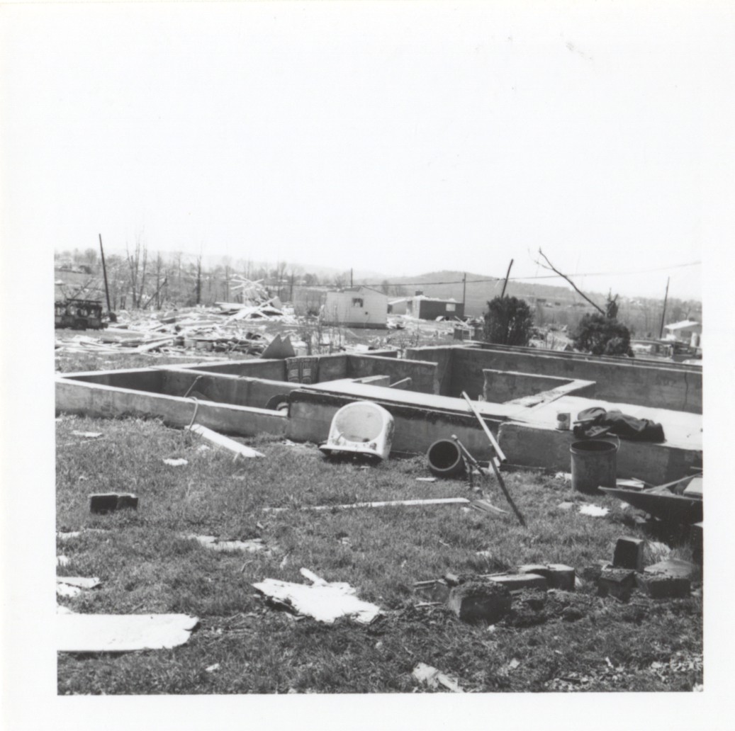
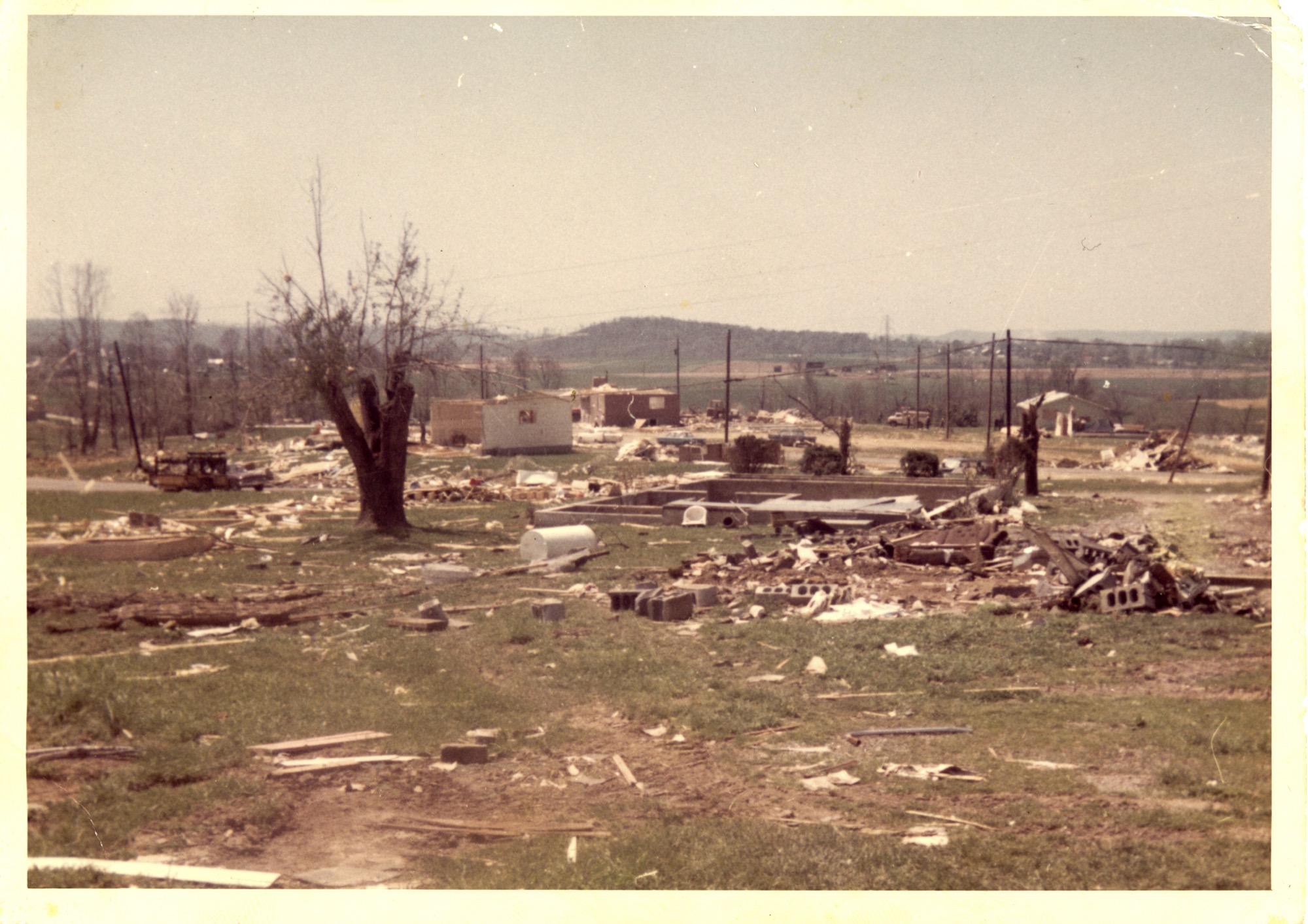
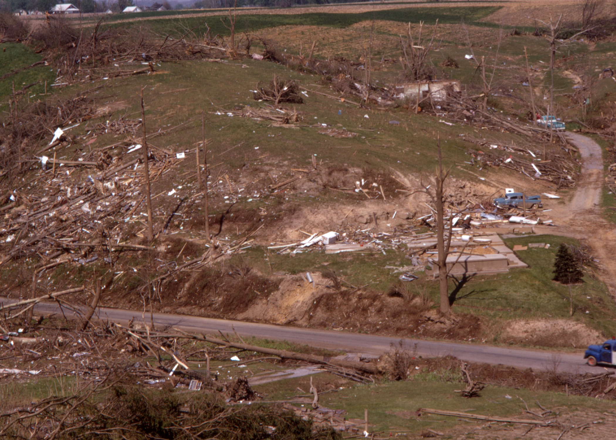
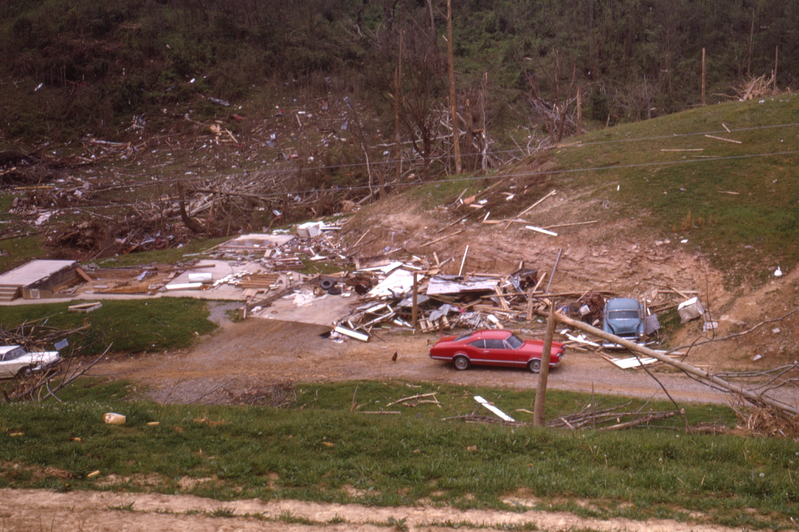
First off, I found a wide-angle shot of the scene at Pinson, Tennessee after it was devastated by a tornado that came after dark on March 11th, 1923. The tornado was spawned during a very widespread and high-end severe weather event. The damaging winds on this day were so widespread that it was referred to as a "hurricane" in newspapers. I believe that the tornado was spawned by a supercell that was able to remain discrete just long enough to produce the tornado. The tornado did not last long, which would fit perfectly with the messy warm sector I had in mind, occluding due to a convective merger.

1629571534147.png

Next, I came across two very intriguing tornado scars in southern Paraguay, one of which was exceptionally large and unusually violent for that area. I knew that they had appeared not too long before 1965, and reanalysis data indicated that they appeared on August 23rd, 1963, the same day where Dr. King delivered his legendary "I have a Dream" speech.

The two scars

ScarB.PNG

Reanalysis for the exact location of the tornado scar at 4:00 PM on August 23rd, 1963. I don't think the SHARPpy algorithm is used to southern hemisphere profiles, explaining why the possible hazard type says "SVR" instead of "PDS TOR." This sounding would generally be too dry to support convection, but the kinematics matched up perfectly with the occurrence of the tornado. After the big one dissipated, no other tornadoes appeared to be produced by the parent supercell responsible.

19630823.png

Another tornado scar in this region appeared sometime in 1978, which reanalysis data helped me conclude that it likely appeared on July 19th, 1978. This data was supported by GOES-2 Satellite Imagery that was available at that time.

The 1978 scar was the only one I found that did not move due SE, rather taking an ENE path, making this one a big unique. It was also unusually large and had a tree damage swath of nearly a mile wide.

19780719PARAGUAY.PNG

Reanalysis Data for the location where the tornado occurred at 4:00 PM on July 19th, 1978. Once again, ERA5 was too dry for convective initiation but other evidence makes it likely that it occurred on July 19th.

19780719CANDIDATE.png

A Brazilian tornado that recently caught my eye occurred on August 29th, 2005 during a very high-end and widespread severe weather outbreak. It was not big in size, but it was big in intensity. Several brick homes in the town of Muitos Capões were simply swept away, and businesses were badly damaged. The tornado scar was detected on LANDSAT imagery in November. It was estimated to have been an F3 but I have some doubts.

20050829BRAZIL.PNG

20050829BRAZIL2.PNG
20050829BRAZIL3.PNG

Now, we'll take a trip down under with, at least from a meteorological point of view, a very unique tornado event. It occurred not far from Darwin, Australia on the early hours of March 1st, 2007. Yes, the same day that a tornado in the opposite hemisphere visited Enterprise, Alabama with serious but lucky consequences. The tornado passed extremely close to a ranger's station in Kakadu State Park, doing massive tree damage. What's most stunning about the tornado, however, is that IT MOVED WEST-NORTHWEST FOR ITS WHOEL LIFESPAN. This is something I have NOT seen a tornado in any hemisphere do before (save for landspouts and a few tornadoes associated with marginal kinematic support). I'll let this news article below speak for itself:

"Rangers at Kakadu National Park had a lucky escape when a powerful tornado carved a trail of destruction through forest near the Mary River Ranger Station two weeks ago. Two unoccupied caravans were totally destroyed and many trees were snapped and felled around the rangers� houses and office. Park ranger Rob Muller said that the noise of the spinning wind was loud like an industrial machine and could be heard for at least 10 minutes as the tornado approached in the dark, then moved slowly away."

Reanalysis sounding from the event

20070301AUSTRALIA.png

EF3-level damage from the tornado

1629572732383.png

The most bizarre tornado of them all touched down in the country you'd least expect, New Zealand in the early morning hours of August 15th, 2004 (local time), north of the city of Waitara. This tornado was associated with a very big and powerful low-pressure system that was located right off the coast of New Zealand. It formed as a waterspout offshore before it made its way ashore, destroying paddocks and snapping power lines. The most jaw-dropping damage occurred next when the tornado cored a farmhouse and an outbuilding. The farmhouse was picked up from its foundation and then thrown to the ground a distance away from the foundation, the impact forces appeared to completely destroy the home. Debris was wind-rowed for an extremely long distance through nearby fields, supposedly over 400 yards but I have doubts that this claim is true. The 4 people inside the home were seriously injured and two of them succumbed to the storm. Unfortunately, I have been unsuccessful in finding images from this event, but it clearly is the strongest tornado to have impacted New Zealand to date. Photos would clear a lot of doubt about this event, and I will update you all if I am successful. For now, the doubts remain.
 
Last edited:
Back
Top