Chris3024
Member
I wonder if the Walker storm ran into a boundary, which caused the direction change. It was moving NE now it seems to be moving SE.
Follow along with the video below to see how to install our site as a web app on your home screen.
Note: This feature may not be available in some browsers.

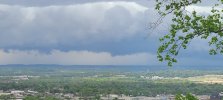
I missed it again. One dramatic thunder clap and some rain.Looks like the hail core has weakened considerably with this storm, which is good since it’s about to pass over me. Still don’t get how it totally changed directions from moving NNW to moving ESE.

Went back up, thankfully Lots of rotation around that area right now.Our local meteorologist, Matt Laubhan, has a tornado on the ground in Union/Lee County, MS on his livestream.
I like him.Went back up, thankfully Lots of rotation around that area right now.