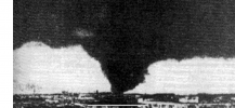
It's hard to tell the true width of that tornado due to the fact that we don't know the base height, and that the tornadic circulation is
always bigger than the actual condensation funnel may show. I did some in-depth satellite research on the Ivanovo Tornado, and the width of the most intense damage I could find definitely suggests the tornado was near a mile wide, if not even larger.
The Ivanovo Tornado's path on satellite can be seen towards the top of the image. What interests me the most about the Ivanovo Tornado's track is how it moved slightly to the NNE, rather than to the NNW, as what was the case with two other tornadic scars I was able to find. This suggests that the parent supercell responsible for the Ivanovo Tornado may have been subject to deviant flow motion, allowing it to take in more wind shear than the other supercells and produce a stronger tornado. However, the tornado's path quickly disappeared after leaving this forested area.
View attachment 6739
Two of the other scars appeared to come from the cycle of a second supercell, further to the west of the Ivanovo Supercell, with the second track starting further to the east of the initial one. Both tracks moved to the NNW as opposed to the NNE This suggests a high critical angle or a messy storm mode was responsible for the rather quick cycles of a supercell, although I believe that the latter is more likely given the sounding that ERA5 Analysis paints.
Here's the first of the two scars from that second supercell
View attachment 6740
The second and final scar I was able to find was much shorter but much larger
View attachment 6741
The low that ERA5 had was very intense (983 mb), and the satellite images paint a classic tropical-cyclone type setup, with the tornadoes occurring on the northeast side of the unusually intense surface low. The quick change in path direction from the Ivanovo supercell to the second supercell further to the west supports this theory as well. This would also explain the short path length, as given a surface low of that intensity, and with tropical cyclone-related tornado setups, it's going to be a messy convective mode with mergers choking off mesocyclones. That's probably what this Ivanovo Tornado Outbreak looked like. I was also unable to find any evidence of a tornado in the Kostroma area.
ERA5 had this for MSLP (Maximum Surface Low Pressure). The tornadoes occurred on the northeastern side of the low.
View attachment 6742
ERA5 Sounding for the prime tornado zone
View attachment 6743


