• Welcome to TalkWeather!
    We see you lurking around TalkWeather! Take the extra step and join us today to view attachments, see less ads and maybe even join the discussion.
    CLICK TO JOIN TALKWEATHER
Logo 468x120

Severe Weather 2021

KevinH

Member
Messages
1,710
Reaction score
2,683
Location
West Central GA
yeah the gfs keeps spitting out fantasy chances of severe. todays 12z run has a dynamic system course way fantasy land, course take that grain of salt. but it tells me were fixing to change gears and start to have pay attention as march draws closer
I am REALLY looking forward to seeing how spring plays out.
 

KevinH

Member
Messages
1,710
Reaction score
2,683
Location
West Central GA
yeah the gfs keeps spitting out fantasy chances of severe. todays 12z run has a dynamic system course way fantasy land, course take that grain of salt. but it tells me were fixing to change gears and start to have pay attention as march draws closer
I am REALLY looking forward to seeing how this spring plays out.
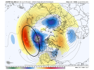
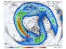
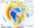
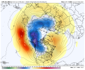
We're getting to the point now where seasonal analogs, seasonal teleconnections, etc., related to the background state are going to start taking a back seat going forward. We have a significant and intensifying -PDO in place, we have a west-based La Nina that is driving a screaming +TNI. We have had pattern suppression for much of the winter to keep the ridge from getting out of control. The classic things we look for in the background state are already there and are only getting increasingly favorable. We know the background state will be there. We're now transitioning to watching things like the progression of the MJO, watching for phase changes in the NAO and AO, etc., to try to get an idea of when the door opens for active periods to begin. Based on what I've seen thus far, I think it gradually begins toward the last part of this month. There's been a somewhat consistent signal for that for around the 24th-25th of this month on the CFS dashboard since way back on January 9th. Now, the timing of a phase change in the NAO/AO, timing of the current MJO wave collapsing toward the COD, etc., all support that general idea. It's also supported by one of our top seasonal analogs...

I still think the peak of the activity is later in March and in April though, but I think the doors open toward the end of this month.
Do you still think all of this is the case, or are things looking different now?
 

Clancy

Member
Messages
2,299
Reaction score
3,977
Location
Macland, Georgia
Hello all! I've been mostly lurking for a good long while, but given how the severe weather season looks like it might go, I figured I'd jump in. Echoing KevinH, I'm also curious about how the larger-scale things are holding up. I wouldn't tend to think a whole lot has changed since the initial evaluations, but I'm interested to hear what everyone thinks about it.
 

KevinH

Member
Messages
1,710
Reaction score
2,683
Location
West Central GA
Hello all! I've been mostly lurking for a good long while, but given how the severe weather season looks like it might go, I figured I'd jump in. Echoing KevinH, I'm also curious about how the larger-scale things are holding up. I wouldn't tend to think a whole lot has changed since the initial evaluations, but I'm interested to hear what everyone thinks about it.
Same. Just looking to see if there have been any updates in the last week. If not, I will wait until March to ask LOL
 

Fred Gossage

Member
Meteorologist
PerryW Project Supporter
Messages
596
Reaction score
2,096
Location
Florence, AL
Everything is not fully on track, but we can see consistent signals of the main spring severe weather pattern solidifying as we head into March on the extended ensemble guidance. I've just been too busy dealing with winter weather mess to be able to take the time to analyze things here. But I'll just say this... Buckle up...
 

KevinH

Member
Messages
1,710
Reaction score
2,683
Location
West Central GA
Everything is not fully on track, but we can see consistent signals of the main spring severe weather pattern solidifying as we head into March on the extended ensemble guidance. I've just been too busy dealing with winter weather mess to be able to take the time to analyze things here. But I'll just say this... Buckle up...
*click*
OK so no changes YET, thank you. I very much look forward to your forthcoming updates as you get caught up! I hate winter.
 

Fred Gossage

Member
Meteorologist
PerryW Project Supporter
Messages
596
Reaction score
2,096
Location
Florence, AL
*click*
OK so no changes YET, thank you. I very much look forward to your forthcoming updates as you get caught up! I hate winter.
We're way past the point of this having a chance to completely derail. We're now at the point of waiting for specific individual systems to track once we get out of this colder pattern. It's coming.
 

KevinH

Member
Messages
1,710
Reaction score
2,683
Location
West Central GA
We're way past the point of this having a chance to completely derail. We're now at the point of waiting for specific individual systems to track once we get out of this colder pattern. It's coming.
Oh hell.
 
Last edited:

KevinH

Member
Messages
1,710
Reaction score
2,683
Location
West Central GA
As winter relaxes, we'll probably see a gradual ramp up over the next several weeks, peaking later into March and April. It's almost that time, and the potential is high end.
Question: how can you still say the potential is high end when we don’t yet know what the smaller scale factors are? Or are you just saying that SO FAR the potential is high end based on what has happened??
 

andyhb

Member
Messages
1,035
Reaction score
2,698
Location
Norman, OK
Question: how can you still say the potential is high end when we don’t yet know what the smaller scale factors are? Or are you just saying that SO FAR the potential is high end based on what has happened??
Not to be short, but haven't you read the rest of this thread?
 

Fred Gossage

Member
Meteorologist
PerryW Project Supporter
Messages
596
Reaction score
2,096
Location
Florence, AL
Question: how can you still say the potential is high end when we don’t yet know what the smaller scale factors are? Or are you just saying that SO FAR the potential is high end based on what has happened??
He means the potential for the pattern and the season as a whole, not one individual event. Based on your questions here and your posts I've seen on Facebook and Twitter, I think that's where you're messing up with this. All this pattern recognition, teleconnections, analog, etc., stuff does not instantly translate to a similar individual event. What it means is that the background state is similar to those years, and it gives a general idea of the overall scope of the season... but it does also mean that something similar to those individual days would be less impossible than it would be in other years. Also, yes, each individual event comes down to the smaller-scale details that we can't know to the exact until a couple days out or closer, but those smaller-scale details get guided a good bit by the larger scale. But it's really important that you understand that "1974 and 2011 are seasonal analogs" does not equate to "watch out for a 4/3/74 and 4/27/2011 repeat". It means "the background state is similar to those years, which is a red flag that it may be an active season and there is the potential for significant, large scale events of some magnitude".
 

KevinH

Member
Messages
1,710
Reaction score
2,683
Location
West Central GA
He means the potential for the pattern and the season as a whole, not one individual event. Based on your questions here and your posts I've seen on Facebook and Twitter, I think that's where you're messing up with this. All this pattern recognition, teleconnections, analog, etc., stuff does not instantly translate to a similar individual event. What it means is that the background state is similar to those years, and it gives a general idea of the overall scope of the season... but it does also mean that something similar to those individual days would be less impossible than it would be in other years. Also, yes, each individual event comes down to the smaller-scale details that we can't know to the exact until a couple days out or closer, but those smaller-scale details get guided a good bit by the larger scale. But it's really important that you understand that "1974 and 2011 are seasonal analogs" does not equate to "watch out for a 4/3/74 and 4/27/2011 repeat". It means "the background state is similar to those years, which is a red flag that it may be an active season and there is the potential for significant, large scale events of some magnitude".
Got it. Thank you for the explanation!
 

andyhb

Member
Messages
1,035
Reaction score
2,698
Location
Norman, OK
If people are looking for a visual representation of what we are talking about, watch this loop of the 12z EPS mean. Notice the ridge that is generally over the East Pacific at the start begin to retrograde (shift westward with time). It allows the jet a pathway to drop into the Pacific NW and amplify western troughing. By the end of the run, there is a large scale regime in place that would favor A) moisture return into the south-central/southeast US and B) a trough or two ejecting from the west to potentially take advantage of that moisture.

36d1253d-dac4-4cb6-9e06-13683824e78b (1).gif
 

Matt Grantham

Member
Meteorologist
Messages
71
Reaction score
291
Location
Pelham, AL
There is an unusually strong signal in the long range for a loading pattern across the Pacific that will have to be closely watched for the second and third week of March. All of the guidance suggests the development of a raging jet stream aimed at the western United States.
 

Attachments

  • ecmwf.png
    ecmwf.png
    760.5 KB · Views: 0
  • ecmwf2.png
    ecmwf2.png
    1 MB · Views: 0
  • gfs-ensemble-all-avg-nhemi-z500_anom-5118400.png
    gfs-ensemble-all-avg-nhemi-z500_anom-5118400.png
    180.3 KB · Views: 0
  • cmc-ensemble-all-avg-nhemi-z500_anom-5118400.png
    cmc-ensemble-all-avg-nhemi-z500_anom-5118400.png
    180.2 KB · Views: 0
  • 500h_anom_tle_6.nh.png
    500h_anom_tle_6.nh.png
    612.6 KB · Views: 0

KevinH

Member
Messages
1,710
Reaction score
2,683
Location
West Central GA
There is an unusually strong signal in the long range for a loading pattern across the Pacific that will have to be closely watched for the second and third week of March. All of the guidance suggests the development of a raging jet stream aimed at the western United States.
Yeah that does not sound (or look) good. I do not understand the graphics you posted, but still does not seem like a GOOD sign for things to come. This might be too early, but which areas would you suggest watching for this timeframe?
 

Matt Grantham

Member
Meteorologist
Messages
71
Reaction score
291
Location
Pelham, AL
Yeah that does not sound (or look) good. I do not understand the graphics you posted, but still does not seem like a GOOD sign for things to come. This might be too early, but which areas would you suggest watching for this timeframe?

We'll have to see how it develops and if it develops, but generally the southern states.
 
Back
Top