• Welcome to TalkWeather!
    We see you lurking around TalkWeather! Take the extra step and join us today to view attachments, see less ads and maybe even join the discussion.
    CLICK TO JOIN TALKWEATHER
Logo 468x120

Severe Weather 2021

Fred Gossage

Member
Meteorologist
PerryW Project Supporter
Messages
596
Reaction score
2,095
Location
Florence, AL
Fred seems to me that at some point i the next couple/few months the severe weather season will rapidly come to life.
We've seen this large scale pattern evolution before. I just don't like publicly talking about such large scale analogs, because the public hears that and incorrectly instantly assumes I'm calling for the repeat of a specific day from that pattern. But you can read between the lines and get my message out of that, I know... The CFS maps above are a carbon copy of the pattern from the same month in that particular year.
 

Richardjacks

Member
Meteorologist
Messages
1,155
Reaction score
1,308
Location
Atop Red Mountain Birmingham, Al
We've seen this large scale pattern evolution before. I just don't like publicly talking about such large scale analogs, because the public hears that and incorrectly instantly assumes I'm calling for the repeat of a specific day from that pattern. But you can read between the lines and get my message out of that, I know... The CFS maps above are a carbon copy of the pattern from the same month in that particular year.
Yep, that's what I was talking about.
 

Fred Gossage

Member
Meteorologist
PerryW Project Supporter
Messages
596
Reaction score
2,095
Location
Florence, AL
There are a lot of moving parts and a good deal of inconsistency, but start watching the second half of next week, especially toward Thursday, as the larger piece of energy ejects out of the Southwest. GFS and now Euro have started to inch toward a more stormy direction, and there is at least some signal for it in ensembles. The Euro weeklies had a look like that for around the third week of January back a few weeks ago. There may be something to it...
 

Richardjacks

Member
Meteorologist
Messages
1,155
Reaction score
1,308
Location
Atop Red Mountain Birmingham, Al
There are a lot of moving parts and a good deal of inconsistency, but start watching the second half of next week, especially toward Thursday, as the larger piece of energy ejects out of the Southwest. GFS and now Euro have started to inch toward a more stormy direction, and there is at least some signal for it in ensembles. The Euro weeklies had a look like that for around the third week of January back a few weeks ago. There may be something to it...
that SE ridge may help set the stage, it is persistent for a good week and will help prime the area, especially for the next system on the following Monday.
 

Fred Gossage

Member
Meteorologist
PerryW Project Supporter
Messages
596
Reaction score
2,095
Location
Florence, AL
1610711200513.png
Looking ahead at longer range stuff, the January analogs from tropicaltidbits.com would suggest an active severe weather season is ahead. Three of those speak for themselves, but for those that don't recognize 1976 that much:

1610711271989.png
March 1976 holds the record number of tornadoes for any March in the United States in official tornado records. There were four separate outbreak systems that month alone.

The top four of five January analogs there on Tidbits suggest an active and possibly violent Dixie Alley season ahead, and the fifth analog would've been the exact same, but there were STJ interference issues that year. We are polar jet driven this year.
 
Last edited:

Fred Gossage

Member
Meteorologist
PerryW Project Supporter
Messages
596
Reaction score
2,095
Location
Florence, AL
image.png.cd63785db1e6ae0c13cf53dc66698caa.png
image.png.0bf73e47351c0e20be888349a9a41e2d.png


The pattern through February on the Euro weeklies shows low amplitude suppression will continue, with only flat, low-latitude oriented subtropical ridging as we begin to start March. That general layout of everything supports the idea that suppression of the pattern doesn't back off until we start heading into spring severe weather season. That particular pattern there is almost a carbon copy of the February pattern from the two listed analogs above that targeted Dixie Alley in April instead of the late winter. I won't say which two because I don't want to be labeled an alarmist by people on here that may not know me, but the winter pattern so far and what the Euro weeklies show for February does not support the other three analogs on the Tidbits list.
 
Messages
2,752
Reaction score
4,288
Location
Madison, WI
Interesting...at least anecdotally, in my memory this winter here in the upper Midwest isn't behaving anything like the two you're thinking of, @Fred Gossage . It should have been a lot more active to this point.
 

Fred Gossage

Member
Meteorologist
PerryW Project Supporter
Messages
596
Reaction score
2,095
Location
Florence, AL
Interesting...at least anecdotally, in my memory this winter here in the upper Midwest isn't behaving anything like the two you're thinking of, @Fred Gossage . It should have been a lot more active to this point.
It's weird. For instance, the analog I've talked about with you in private, in particular... there was a good bit more snowpack through the Midwest by now that year (but I think that's about to start playing catch up) and other differences that agree with your point... but down here, it's played out so similarly in such detail that we're talking about specific weather systems on specific calendar days... a light snow threat on Christmas Eve night, a severe weather system on New Year's Eve, and a heavy wet accumulating Gulf low snow system around the 9th-11th of January. All that in a general pattern that has roughly behaved similarly overall since December. It's weird how it can be so similar here and so different elsewhere, when the overall large-scale upper-level pattern over the whole CONUS if not North America overall has matched pretty well to that analog so far.
 
Messages
1,029
Reaction score
1,216
Location
jackson tennessee
Special Affiliations
  1. SKYWARN® Volunteer
It's weird. For instance, the analog I've talked about with you in private, in particular... there was a good bit more snowpack through the Midwest by now that year (but I think that's about to start playing catch up) and other differences that agree with your point... but down here, it's played out so similarly in such detail that we're talking about specific weather systems on specific calendar days... a light snow threat on Christmas Eve night, a severe weather system on New Year's Eve, and a heavy wet accumulating Gulf low snow system around the 9th-11th of January. All that in a general pattern that has roughly behaved similarly overall since December. It's weird how it can be so similar here and so different elsewhere, when the overall large-scale upper-level pattern over the whole CONUS if not North America overall has matched pretty well to that analog so far.
cough april 74, april 2011?
 

Fred Gossage

Member
Meteorologist
PerryW Project Supporter
Messages
596
Reaction score
2,095
Location
Florence, AL
cough april 74, april 2011?
I will just say that all of those highlighted analogs above should show that the general large scale pattern is there for a potentially active severe weather season ahead, and not just in numbers but in the potential for a large scale intense event or two. All four of the years highlighted in the analog chart had high-end days. When you use certain "celebrity" analogs, people instantly blank out and think you're automatically calling for a repeat of the "celebrity" event itself, and I'm not, and we're not going there. Even if you have the exact same setup on the hemispheric or global level, it is up to individual synoptic systems to take full advantage of the background state, and then it is up to the mesoscale of one of those to take full advantage of its synoptic setup. And that is something we just can't know until we are running up on an individual system. But with everything in place, I just can't see how we can avoid an active stretch in a few months from now, with a higher-than-usual chance of a headliner type day or two.
 

Fred Gossage

Member
Meteorologist
PerryW Project Supporter
Messages
596
Reaction score
2,095
Location
Florence, AL
We've talked about the TNI (Trans-Nino Index) here a few times. For those of you that are wondering how it is calculated, here is the simple formula:

(ENSO Region 1+2) - (ENSO Region 4) = TNI

You can use that to keep up with it weekly as the CPC ENSO readings come out each week for the week before. You can also keep watch on it daily via the daily readings available on TropicalTidbits.com to at least get a rough idea. However, we know that the data on there often has a slight inconsistency compared with the officially released numbers. For instance, last week's Region 4 value was -1.2C. Tidbits has shown steadily daily cooling in Region 4 for the last two weeks at least, as you would expect, but in that whole period, the daily values have not been as low as -1.2C yet. They are just now approaching -1.18C. So, the Tidbits data requires a little caution, but it's usually not too terribly far off.
 

andyhb

Member
Messages
1,033
Reaction score
2,689
Location
Norman, OK
Looks like some relaxation of the strong trades (interference by the intraseasonal signal) may be coming near the dateline per the Hovmollers.
 

andyhb

Member
Messages
1,033
Reaction score
2,689
Location
Norman, OK
For us lay people, what is the significance of that RE: spring 2021 severe weather potential?
Might be the signs of the Nina reaching its peak (actually it probably already has done so in the eastern regions), although Nino 4 should remain cool for awhile. Fred's been discussing it at length above in the thread what it might mean for severe potential.
 

Fred Gossage

Member
Meteorologist
PerryW Project Supporter
Messages
596
Reaction score
2,095
Location
Florence, AL
Most model guidance shows the upper-level pattern starting to change toward this weekend as the big -NAO block we've had forever looks to finally start weakening. That may open the door for ridging to start to take hold over the Bahamas, at least flat low amplitude ridging. That may set it up so that we stop continental air from recirculating back into the Caribbean and eastern Gulf... just in time for a system to eject out early next week. With how models have behaved lately, I'm not ready to trust a severe weather threat with the storm. But it looks like the Gulf may actually be able to have quality moisture on a large scale. If that is the case, this will be one of the first times for the whole cool season.
 

Austin Dawg

Member
Sustaining Member
Messages
852
Reaction score
1,299
Location
Leander, Texas
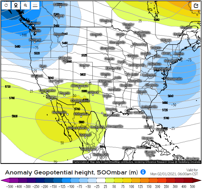
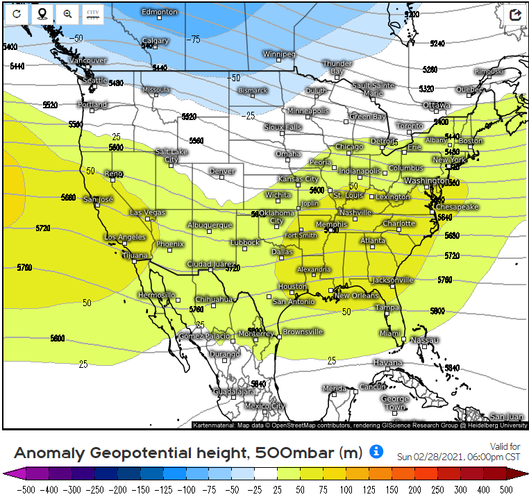
View attachment 5667 View attachment 5668 View attachment 5669
Euro weeklies have the spring pattern setting up by the end of February, and it looks exactly how we didn't want it to look... and confirms every suspicion we've had since at least mid summer.

Do these patterns you are observing give any indication of possible jetstream patterns that lead to severe events or just the overall zonal patterns. It's been my layman's understanding that jet streams are one of the key components for BIG severe events and just a big batch of stronger storms.
 

Fred Gossage

Member
Meteorologist
PerryW Project Supporter
Messages
596
Reaction score
2,095
Location
Florence, AL
Do these patterns you are observing give any indication of possible jetstream patterns that lead to severe events or just the overall zonal patterns. It's been my layman's understanding that jet streams are one of the key components for BIG severe events and just a big batch of stronger storms.
The various branches of the jet stream are what drive all weather patterns, every day of the year. Not just severe weather, not just winter weather, etc.

For this, there are certain things I'm looking for on the large scale... such as a general low amplitude pattern over the CONUS that features general troughing in the west and flat ridging in the east. That general pattern gathers together the main synoptic ingredients necessary for severe weather events... such as low-level moisture return, large scale vertical wind shear, strong synoptic scale storm systems that would eject out of the Plains into our region of the country, etc.
 

Austin Dawg

Member
Sustaining Member
Messages
852
Reaction score
1,299
Location
Leander, Texas
The various branches of the jet stream are what drive all weather patterns, every day of the year. Not just severe weather, not just winter weather, etc.

For this, there are certain things I'm looking for on the large scale... such as a general low amplitude pattern over the CONUS that features general troughing in the west and flat ridging in the east. That general pattern gathers together the main synoptic ingredients necessary for severe weather events... such as low-level moisture return, large scale vertical wind shear, strong synoptic scale storm systems that would eject out of the Plains into our region of the country, etc.

Thanks. I was just remembering where meteorologists used graphics to talk about those things you mentioned and most of the time talked about opposing jets at different altitudes playing a part and I was just curious how intricate these analogs were.
 
Back
Top