• Welcome to TalkWeather!
    We see you lurking around TalkWeather! Take the extra step and join us today to view attachments, see less ads and maybe even join the discussion.
    CLICK TO JOIN TALKWEATHER
Logo 468x120

Severe WX Severe Weather Threat 4/2/17-4/3/17

TWBot

TalkWeather Bot
Don't Feed The Bots
Messages
542
Reaction score
2
Location
On a server
MD 0396 CONCERNING SEVERE POTENTIAL...WATCH LIKELY FOR PORTIONS OF THE EDWARDS PLATEAU AND THE TEXAS HILL COUNTRY


Mesoscale Discussion 0396
NWS Storm Prediction Center Norman OK
1006 PM CDT Sat Apr 01 2017

Areas affected...Portions of the Edwards Plateau and the Texas Hill
Country

Concerning...Severe potential...Watch likely

Valid 020306Z - 020500Z

Probability of Watch Issuance...80 percent

SUMMARY...Thunderstorms will increase in coverage across southwest
Texas late this evening, before eventually spreading east/northeast
towards morning. Initially, large hail and damaging winds will be
the primary threat. However, a threat for a couple tornadoes will
likely materialize overnight as storms develop east. Watch issuance
is likely within the next couple of hours.

DISCUSSION...Convection has once again blossomed over the Serranias
del Burro mountains late this evening, likely in response to
amplifying large-scale ascent related to a strengthening upper level
jet. It is uncertain whether these cells are the beginning of a more
organized expansion of convection through the overnight hours.
However, as a southeasterly low-level jet and related moist/warm
advection intensify over the next several hours, confidence is high
that more widespread thunderstorm activity will develop near the Rio
Grande ahead of a cold front to the northwest. Initially, this
activity will interact with surface dew points in the upper 50s to
near 60. Combined with steep mid-level lapse rates and ample
effective shear (both observed in the 00Z DRT sounding), these cells
will be capable of large hail and damaging winds.

Through the early overnight however, low-level moisture will surge
westward as surface-to-850mb east/southeasterly flow intensifies.
Surface observations depict dew points in the mid/upper 60s over
south-central Texas, and this greater moisture should advance
westward quickly. Therefore, cells will evolve eastward into an
environment characterized by 2000+ J/kg of MLCAPE. Combined with
notable low-level speed shear and some veering with height, a threat
for a couple tornadoes should gradually increase through the night,
especially with eastward extent. Therefore, despite the uncertainty
regarding timing of the organized severe threat, a watch will be
likely within the next couple hours.

..Picca/Edwards.. 04/02/2017

...Please see www.spc.noaa.gov for graphic product...

ATTN...WFO...EWX...SJT...MAF...

LAT...LON 29830178 30210139 30540013 30679904 30519847 29889816
29319851 28809972 28800048 29430099 29830178


Read more

For additional SPC information click here
 
Messages
452
Reaction score
380
Location
Canton, GA
Day 2 enhanced with 30% hatch for most of Southern and Central Alabama, Florida Panhandle, and most of North and Central Georgia. Strong tornado wording was also included.
 
Messages
179
Reaction score
59
Location
Adel, Ga
Day 2 enhanced with 30% hatch for most of Southern and Central Alabama, Florida Panhandle, and most of North and Central Georgia. Strong tornado wording was also included.

That's about 3 severe categories higher than I'd prefer to be in so plenty bad enough but all eyes on the people in Tx/La where they maintained the moderate risk with a 15% hatched tornado!

AL Risk saved image of day 2 30% hatched for all in enhanced/category 3 of 5

AL_swody2.png
 
  • Thread starter
  • Moderator
  • #44

Taylor Campbell

Moderator
Moderator
PerryW Project Supporter
Messages
2,102
Reaction score
2,189
Location
Wedowee, AL
Special Affiliations
  1. SKYWARN® Volunteer
Day 2 enhanced with 30% hatch for most of Southern and Central Alabama, Florida Panhandle, and most of North and Central Georgia. Strong tornado wording was also included.

...Southeast...
At least the remnants of a substantial mesoscale convective system
probably will be in the process of advancing east of the lower
Mississippi Valley at the beginning of the period. And guidance
appears increasingly suggestive that a preceding corridor of
appreciable boundary layer moistening and destabilization will keep
pace with it, contributing to the potential maintenance or
re-invigoration of activity through the day Monday. In the presence
of ambient wind profiles characterized by strong deep layer shear
and large-clockwise curved low-level hodographs (near a 50+ kt
southerly 850 mb jet), the environment appears more than favorable
for an organized damaging wind threat, along with a few tornadoes.

Discrete supercell development appears possible ahead of the
convective system, particularly later in the day across the piedmont
of Alabama into Georgia, on the southern fringe of the stronger
forcing associated with the mid/upper trough. This activity may
persist and possibly grow upscale into another evolving convective
system, spreading into the Carolina piedmont late Monday afternoon
and evening. Severe wind gusts/hail and tornadoes all appear
possible with this activity.

I think this was a good idea by the SPC. The model agreement and trends strongly favor it.
 

Tyler Penland

Mountain Snow Miser
Staff member
Moderator
Messages
254
Reaction score
154
Location
Blowing Rock, NC; Elevation 3,575ft
Day 2 enhanced with 30% hatch for most of Southern and Central Alabama, Florida Panhandle, and most of North and Central Georgia. Strong tornado wording was also included.

I'm a bit antsy about Monday. Things have been trending more ominous for GA . Likely the best set-up North GA has seen in quite some time (though that's not really saying a ton).
 

TWBot

TalkWeather Bot
Don't Feed The Bots
Messages
542
Reaction score
2
Location
On a server
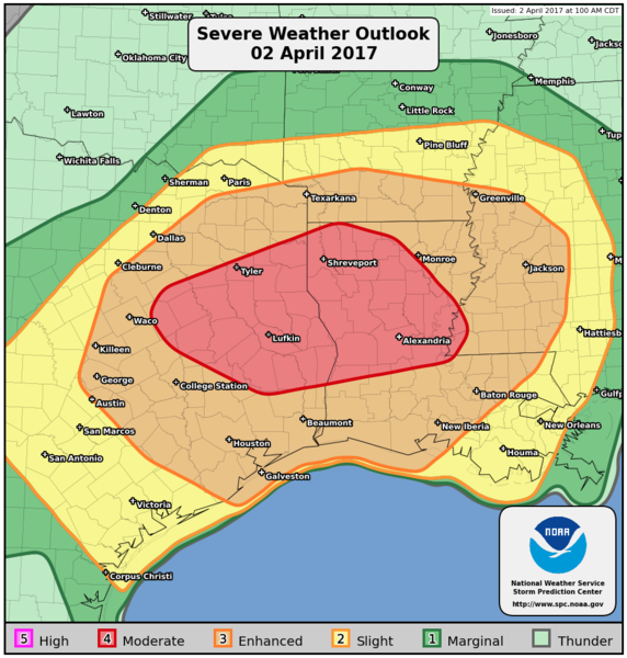
Public Severe Weather Outlook
swo_sm_201704020615.png


PUBLIC SEVERE WEATHER OUTLOOK
NWS STORM PREDICTION CENTER NORMAN OK
0114 AM CDT SUN APR 02 2017

...Severe thunderstorms expected over parts of the lower Mississippi
Valley and central/east Texas later today and tonight...

* LOCATIONS...
Central and East Texas
Louisiana
Southern Arkansas
Central and Southern Mississippi

* HAZARDS...
Widespread damaging winds, some hurricane force
Several tornadoes, a few intense
Scattered large hail, some baseball size

* SUMMARY...
Numerous severe thunderstorms are forecast from parts of Texas
eastward into the lower Mississippi Valley later today and
continuing into tonight. A concentrated area of significant wind
damage is likely near and north of the I-20 corridor in east
Texas and Louisiana. The risk for tornadoes, a few of which may
be strong/damaging, will probably maximize near and south of
I-20 in Texas and Louisiana, along with the threat for very
large hail.

Preparedness actions...

Review your severe weather safety procedures for the possibility
of dangerous weather today. Stay tuned to NOAA Weather Radio,
weather.gov, or other media for watches and warnings. A watch
means that conditions are favorable for severe thunderstorms
over the next several hours. If a severe thunderstorm warning is
issued for your area, move to a place of safety, ideally in an
interior room on the lowest floor of a sturdy building.

Read more

For additional SPC information click here
 
Last edited by a moderator:

TWBot

TalkWeather Bot
Don't Feed The Bots
Messages
542
Reaction score
2
Location
On a server
Public Severe Weather Outlook


PUBLIC SEVERE WEATHER OUTLOOK
NWS STORM PREDICTION CENTER NORMAN OK
0114 AM CDT SUN APR 02 2017

...Severe thunderstorms expected over parts of the lower Mississippi
Valley and central/east Texas later today and tonight...

* LOCATIONS...
Central and East Texas
Louisiana
Southern Arkansas
Central and Southern Mississippi

* HAZARDS...
Widespread damaging winds, some hurricane force
Several tornadoes, a few intense
Scattered large hail, some baseball size

* SUMMARY...
Numerous severe thunderstorms are forecast from parts of Texas
eastward into the lower Mississippi Valley later today and
continuing into tonight. A concentrated area of significant wind
damage is likely near and north of the I-20 corridor in east
Texas and Louisiana. The risk for tornadoes, a few of which may
be strong/damaging, will probably maximize near and south of
I-20 in Texas and Louisiana, along with the threat for very
large hail.

Preparedness actions...

Review your severe weather safety procedures for the possibility
of dangerous weather today. Stay tuned to NOAA Weather Radio,
weather.gov, or other media for watches and warnings. A watch
means that conditions are favorable for severe thunderstorms
over the next several hours. If a severe thunderstorm warning is
issued for your area, move to a place of safety, ideally in an
interior room on the lowest floor of a sturdy building.

Read more

For additional SPC information click here
 

TWBot

TalkWeather Bot
Don't Feed The Bots
Messages
542
Reaction score
2
Location
On a server
MD 0397 CONCERNING TORNADO WATCH 107... FOR SOUTH-CENTRAL AND SOUTHWEST TX


Mesoscale Discussion 0397
NWS Storm Prediction Center Norman OK
0247 AM CDT Sun Apr 02 2017

Areas affected...South-central and southwest TX

Concerning...Tornado Watch 107...

Valid 020747Z - 020915Z

The severe weather threat for Tornado Watch 107 continues.

SUMMARY...Severe storms remain likely across the western half of WW
107 with large hail and damaging winds being the primary threat in
the short term trough 09Z. Trends with the southern most discrete
storm in northern Coahuila Mexico suggest it could move into
northwest Maverick county TX by 08Z. Local WFO areal extension may
be needed on the southern part of WW 107.

DISCUSSION...Early overnight trends in mosaic radar imagery
indicated the strongest storms capable of producing severe-weather
(mainly hail and/or damaging winds, at this time) extended from
southern Val Verde county to south of the International border in
northern Coahuila (60 SW to 35 S of DRT). This activity was located
equatorward of the southern extent of a convectively reinforced cold
front, which at 07Z extended from San Saba County to near KJCT to
northern Val Verde County. IR satellite imagery indicated the
coldest cloud tops were located along the International border with
Val Verde County, while radar imagery showed new thunderstorm
development occurring along the southwest flank (in northern
Coahuila) of this cluster of thunderstorms.

Forcing for ascent attendant to an apparent midlevel impulse moving
from the TX Big Bend region into the Edwards Plateau and height
falls with the approaching this region from Chihuahua Mexico and Far
West TX are expected to maintain this cluster of storms into the
early morning. Forecast veering of 40 kt 850-mb and 700-mb jets to
southerly and southwesterly overnight into this morning should
result in an east-northeast advancement of the organizing MCS along
the International border into Val Verde and Kinney Counties. The
03Z ESRL-HRRR continues to show this evolution in storm mode, given
a persistent influx of rich moisture from the northwest Gulf of
Mexico combined with strong effective bulk shear of 50+ kt.

Farther north across northern Val Verde to Sutton Counties, the
severe-weather threat appears to be diminishing as the air mass has
been convectively overturned. Thunderstorms should persist
overnight, though the severe risk is likely lower than earlier.

..Peters.. 04/02/2017

...Please see www.spc.noaa.gov for graphic product...

ATTN...WFO...EWX...SJT...

LAT...LON 28890058 29400094 29800143 30240085 30580008 30779914
30399872 29509885 29139885 28829969 28740030 28890058

28890058 29400094 29800143 30240085 30580008 30779914 30399872
29509885 29139885 28829969 28740030 28890058


Read more

For additional SPC information click here
 

TWBot

TalkWeather Bot
Don't Feed The Bots
Messages
542
Reaction score
2
Location
On a server
Public Severe Weather Outlook


PUBLIC SEVERE WEATHER OUTLOOK
NWS STORM PREDICTION CENTER NORMAN OK
0114 AM CDT SUN APR 02 2017

...Severe thunderstorms expected over parts of the lower Mississippi
Valley and central/east Texas later today and tonight...

* LOCATIONS...
Central and East Texas
Louisiana
Southern Arkansas
Central and Southern Mississippi

* HAZARDS...
Widespread damaging winds, some hurricane force
Several tornadoes, a few intense
Scattered large hail, some baseball size

* SUMMARY...
Numerous severe thunderstorms are forecast from parts of Texas
eastward into the lower Mississippi Valley later today and
continuing into tonight. A concentrated area of significant wind
damage is likely near and north of the I-20 corridor in east
Texas and Louisiana. The risk for tornadoes, a few of which may
be strong/damaging, will probably maximize near and south of
I-20 in Texas and Louisiana, along with the threat for very
large hail.

Preparedness actions...

Review your severe weather safety procedures for the possibility
of dangerous weather today. Stay tuned to NOAA Weather Radio,
weather.gov, or other media for watches and warnings. A watch
means that conditions are favorable for severe thunderstorms
over the next several hours. If a severe thunderstorm warning is
issued for your area, move to a place of safety, ideally in an
interior room on the lowest floor of a sturdy building.

Read more

For additional SPC information click here
 

TWBot

TalkWeather Bot
Don't Feed The Bots
Messages
542
Reaction score
2
Location
On a server
Public Severe Weather Outlook


PUBLIC SEVERE WEATHER OUTLOOK
NWS STORM PREDICTION CENTER NORMAN OK
0114 AM CDT SUN APR 02 2017

...Severe thunderstorms expected over parts of the lower Mississippi
Valley and central/east Texas later today and tonight...

* LOCATIONS...
Central and East Texas
Louisiana
Southern Arkansas
Central and Southern Mississippi

* HAZARDS...
Widespread damaging winds, some hurricane force
Several tornadoes, a few intense
Scattered large hail, some baseball size

* SUMMARY...
Numerous severe thunderstorms are forecast from parts of Texas
eastward into the lower Mississippi Valley later today and
continuing into tonight. A concentrated area of significant wind
damage is likely near and north of the I-20 corridor in east
Texas and Louisiana. The risk for tornadoes, a few of which may
be strong/damaging, will probably maximize near and south of
I-20 in Texas and Louisiana, along with the threat for very
large hail.

Preparedness actions...

Review your severe weather safety procedures for the possibility
of dangerous weather today. Stay tuned to NOAA Weather Radio,
weather.gov, or other media for watches and warnings. A watch
means that conditions are favorable for severe thunderstorms
over the next several hours. If a severe thunderstorm warning is
issued for your area, move to a place of safety, ideally in an
interior room on the lowest floor of a sturdy building.

Read more

For additional SPC information click here
 

TWBot

TalkWeather Bot
Don't Feed The Bots
Messages
542
Reaction score
2
Location
On a server
MD 0398 CONCERNING SEVERE POTENTIAL...WATCH LIKELY FOR SOUTH-CENTRAL TO NORTHEAST TX


Mesoscale Discussion 0398
NWS Storm Prediction Center Norman OK
0516 AM CDT Sun Apr 02 2017

Areas affected...South-central to northeast TX

Concerning...Severe potential...Watch likely

Valid 021016Z - 021215Z

Probability of Watch Issuance...95 percent

SUMMARY...A new tornado watch will be issued by 1030-11Z for
portions of south-central to northeast TX. All severe hazards will
be possible through this morning into the afternoon across the
discussion area.

DISCUSSION...Ongoing strong to severe storms located in central and
southwest portions of WW 107 are embedded within an MCS with the
likelihood for MCV formation in this complex, given an extended
period of latent heat release. Meanwhile, additional cloud-top
cooling per IR satellite imagery and reflectivity developing from
the vicinity of KAUS to KHOU is occurring within strengthening
low-level warm air advection on the north edge of the surface warm
sector. A strengthening and veering low-level jet has maintained
rich moisture return across south-central into central and southeast
TX overnight, with ongoing destabilization expected to persist
through the morning into the afternoon across the discussion area.
Strengthening vertically veering winds with the approach of the
mid-upper level trough into southwest and central TX will sustain
strong bulk shear and increasing low-level shear to support both
bowing lines and supercells. Surface-based supercells will become
more probable across the northern extent of the warm sector toward
midday. There will be a gradual increase in damaging winds, hail,
and tornado threats through the day.

..Peters/Thompson.. 04/02/2017

...Please see www.spc.noaa.gov for graphic product...

ATTN...WFO...LCH...SHV...HGX...FWD...CRP...EWX...SJT...

LAT...LON 28839976 30389970 31639779 32359682 33159548 33339477
32189468 31159434 30559524 29759704 29349770 28749902
28489957 28839976


Read more

For additional SPC information click here
 

TWBot

TalkWeather Bot
Don't Feed The Bots
Messages
542
Reaction score
2
Location
On a server
Public Severe Weather Outlook


PUBLIC SEVERE WEATHER OUTLOOK
NWS STORM PREDICTION CENTER NORMAN OK
0800 AM CDT SUN APR 02 2017

...Severe thunderstorms expected over parts of the lower Mississippi
Valley region to east Texas today and tonight...

* LOCATIONS...
East Texas
Northern and central Louisiana
Extreme southern Arkansas
Southwest and central Mississippi

* HAZARDS...
Widespread damaging winds, some hurricane force
Several tornadoes, a few intense
Scattered large hail, some baseball size

* SUMMARY...
A severe thunderstorm cluster will likely affect central and
northeast Texas into southern Arkansas and northern Louisiana
today with widespread damaging winds, a few tornadoes, and large
hail. Tornadic supercells will be possible from east central
Texas across central and northern Louisiana, immediately south
of the track of the larger thunderstorm cluster. The risk for
damaging winds and a few tornadoes will persist overnight across
Louisiana and Mississippi.

Preparedness actions...

Review your severe weather safety procedures for the possibility
of dangerous weather today. Stay tuned to NOAA Weather Radio,
weather.gov, or other media for watches and warnings. A watch
means that conditions are favorable for severe thunderstorms
over the next several hours. If a severe thunderstorm warning is
issued for your area, move to a place of safety, ideally in an
interior room on the lowest floor of a sturdy building.

Read more

For additional SPC information click here
 

akt1985

Member
Messages
1,009
Reaction score
510
Location
Madison, Alabama
As far as the weather for north Alabama, especially Huntsville metro, for the Monday morning commute just a lot of rain with some rumbles of thunder and maybe some small hail? I have to drive from Huntsville to Athens early Monday morning for a magazine interview and am curious to see how bad it will get. Of course if the weather is too bad, I will have to postpone the interview.
 

Kory

Member
Messages
4,928
Reaction score
2,119
Location
Tuscaloosa, Alabama
As far as the weather for north Alabama, especially Huntsville metro, for the Monday morning commute just a lot of rain with some rumbles of thunder and maybe some small hail? I have to drive from Huntsville to Athens early Monday morning for a magazine interview and am curious to see how bad it will get. Of course if the weather is too bad, I will have to postpone the interview.
HRRR is not very enthused about getting surface destabilization north of I-20/59. Looks like elevated storms capable of producing some stronger wind gusts and heavy rain Monday morning with a potent MCS. But the core of it should stay south of north Alabama according to current CAMs.
 

TWBot

TalkWeather Bot
Don't Feed The Bots
Messages
542
Reaction score
2
Location
On a server
Public Severe Weather Outlook


PUBLIC SEVERE WEATHER OUTLOOK
NWS STORM PREDICTION CENTER NORMAN OK
0800 AM CDT SUN APR 02 2017

...Severe thunderstorms expected over parts of the lower Mississippi
Valley region to east Texas today and tonight...

* LOCATIONS...
East Texas
Northern and central Louisiana
Extreme southern Arkansas
Southwest and central Mississippi

* HAZARDS...
Widespread damaging winds, some hurricane force
Several tornadoes, a few intense
Scattered large hail, some baseball size

* SUMMARY...
A severe thunderstorm cluster will likely affect central and
northeast Texas into southern Arkansas and northern Louisiana
today with widespread damaging winds, a few tornadoes, and large
hail. Tornadic supercells will be possible from east central
Texas across central and northern Louisiana, immediately south
of the track of the larger thunderstorm cluster. The risk for
damaging winds and a few tornadoes will persist overnight across
Louisiana and Mississippi.

Preparedness actions...

Review your severe weather safety procedures for the possibility
of dangerous weather today. Stay tuned to NOAA Weather Radio,
weather.gov, or other media for watches and warnings. A watch
means that conditions are favorable for severe thunderstorms
over the next several hours. If a severe thunderstorm warning is
issued for your area, move to a place of safety, ideally in an
interior room on the lowest floor of a sturdy building.

Read more

For additional SPC information click here
 

TWBot

TalkWeather Bot
Don't Feed The Bots
Messages
542
Reaction score
2
Location
On a server
MD 0399 CONCERNING SEVERE POTENTIAL...TORNADO WATCH LIKELY FOR EASTERN TEXAS THROUGH EXTREME WESTERN LOUISIANA


Mesoscale Discussion 0399
NWS Storm Prediction Center Norman OK
0904 AM CDT Sun Apr 02 2017

Areas affected...eastern Texas through extreme western Louisiana

Concerning...Severe potential...Tornado Watch likely

Valid 021404Z - 021630Z

Probability of Watch Issuance...95 percent

SUMMARY...The threat for tornadoes is expected to increase from late
morning into the afternoon over a portion of east TX. A tornado
watch will likely be issued for parts of east TX into western LA by
16Z, and a PDS tornado watch is being considered. The new watch
might also replace the eastern portion of tornado watch 108.

DISCUSSION...Early this morning numerous discrete to semi-discrete
storms including supercells are developing within a zone of warm
advection and isentropic ascent in the vicinity of a warm front
located from southern LA through eastern TX. The storms north of the
warm front are likely slightly elevated, while activity along and
just south of this boundary are probably ingesting
near-surface-based inflow parcels.

Current expectations are for the storms well north of the warm front
to weaken as they move north into the more stable boundary layer
across northeast TX, but may still pose a short term large hail
threat. Visible imagery indicates some diabatic warming may commence
by mid morning over southeast TX, contributing to further boundary
layer destabilization near the warm front. The front should move
slowly north as the low-level jet strengthens across eastern TX into
far western LA in response to forcing for ascent within exit region
of an upper jet rotating through base of synoptic trough. Increasing
0-1 km hodograph size resulting from the strengthening LLJ and
destabilization of the boundary layer should contribute to an
increasing threat for supercells with strong low-level mesocyclones
and tornadoes as storms continue developing in vicinity of the warm
front.

..Dial/Hart.. 04/02/2017

...Please see www.spc.noaa.gov for graphic product...

ATTN...WFO...LCH...SHV...HGX...FWD...

LAT...LON 31489588 31999457 31709347 31169310 30469325 30339473
30209578 31489588


Read more

For additional SPC information click here
 
Back
Top