- Staff
- #261
I thought the HRRR is the next thing you trust after the GFS lines up...
Follow along with the video below to see how to install our site as a web app on your home screen.
Note: This feature may not be available in some browsers.
I thought the HRRR is the next thing you trust after the GFS lines up...
Well to be fair (I have no scientific evidence behind this) from my experience NMMB always tends be to very blobby and messy.There's always one, to throw a little uncertainty into the mix.
I'm wary of how it performed with late March's event. WRFs are solid CAMs that certainly carry weight.I thought the HRRR is the next thing you trust after the GFS lines up...
Looks like it keeps everything south of the Tennessee River. Or am I drawing too many conclusions?And the CAMs (NSSL and ARW) are showing a stunt northward progression of the warm front trapping it in Northern MS/AL, but has some wicked cells riding that thermal boundary. Very 4/24/10-esque with long tracked supercells across MS/AL.


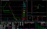
you don't have to happen to have a 500 mb chart for that day?Just as a reference point, here is the 12Z JAN sounding from April 24th, 2010.
Very incorrect assessment!! Maybe you need to reread that thread
I think pinpointing where exactly the boundaries set up will definitely be the morning of kind of deal. Multiple rounds of storms reinforce the warm front south of the TN river on the WRF models. But that can fluctuate. I think the main thing to take away is the nasty atmosphere that will be along and south of that warm front. That has violent tornado potential...hands down.Looks like it keeps everything south of the Tennessee River. Or am I drawing too many conclusions?
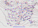
Valid 18z 4/24/10...you don't have to happen to have a 500 mb chart for that day?

Here is the 12Z 500 mb analysis from the SPC, same time as the sounding (from here).you don't have to happen to have a 500 mb chart for that day?
I will say this, as a weather geek, I have in a sense been guilty of "rooting for" violent weather like tornado outbreaks and hurricanes to reach their ceiling, not that I'm wishing death and destruction on people, but because I like to be amazed by what the atmosphere can do, and I know that I have no control over it one way or the other.
That said, the ongoing COVID-19 pandemic has significantly tempered my enthusiasm. I didn't chase the March 28th event just south of my backyard so as not to fly in the face of stay-at-home orders in both Wisconsin and Illinois (although the morning convection made that a less agonizing decision). Just the thought of the logistics of trying to shelter from tornadoes and dealing with the aftermath; with first responders and hospitals already overtaxed, is heartbreaking.
Tornadoes at least come, you take cover, they pass. There's not a siren that goes off, an alert on your phone, and a TV cut-in that warns you when you're within six feet of someone with the coronavirus.
Looks like we got our failure modes.
Yeah that "analysis" is really devoid of context. It's not gonna be like a couple of weeks ago where the convection worked over the warm sector and that was it. There's still plenty of instability ready to be transported up over the moderate risk area after it, which wasn't the case a couple of weeks ago. Big difference between Mississippi/Alabama and Illinois in that respect. That's a common enough feature of major severe weather events in the southeast that you'd think people would be aware of it...Disagree strongly. No cold pooling, no backbuilding of convection, and steeper lapse rates are advecting from the SW. If anything, this enhances a portion of the warm sector. Strong LLJ will allow rapid recovery of the atmosphere over a majority of MS/AL
But I guess he was quick to hit the send button on the tweeter before analyzing the rest of the run...
Yeah that "analysis" is really devoid of context. It's not gonna be like a couple of weeks ago where the convection worked over the warm sector and that was it. There's still plenty of instability ready to be transported up over the moderate risk area after it, which wasn't the case a couple of weeks ago. Big difference between Mississippi/Alabama and Illinois in that respect. That's a common enough feature of major severe weather events in the southeast that you'd think people would be aware of it...
is it just me or does the trough appear to be a bit more compact than Sunday's?Valid 18z 4/24/10...
03-04 April 1974 is the only outbreak in recent history that really ranks ahead of 27 April 2011. Had the morning convection cleared from TNSome have thrown around the 4/27/11 date, but what about 4/3/74? If we're starting to see the possibility of this many states affected...the whole thing is making me sick.
There are more weather threads on the internet. I wasn't trying to single anyone out. However, I will defer to you here, the admin, and delete the post. I appreciate you allowing me to be a member here, and I sincerely apologize for offending you and/or any of the members on Talk Weather.Very incorrect assessment!! Maybe you need to reread that thread
Yes and occluded. This trough is a bit different in structure.is it just me or does the trough appear to be a bit more compact than Sunday's?