• Welcome to TalkWeather!
    We see you lurking around TalkWeather! Take the extra step and join us today to view attachments, see less ads and maybe even join the discussion.
    CLICK TO JOIN TALKWEATHER

Severe WX Severe Weather Threat 2/27/17-3/2/17

Equus

Member
Messages
3,295
Reaction score
3,380
Location
Jasper, AL
Special Affiliations
  1. SKYWARN® Volunteer
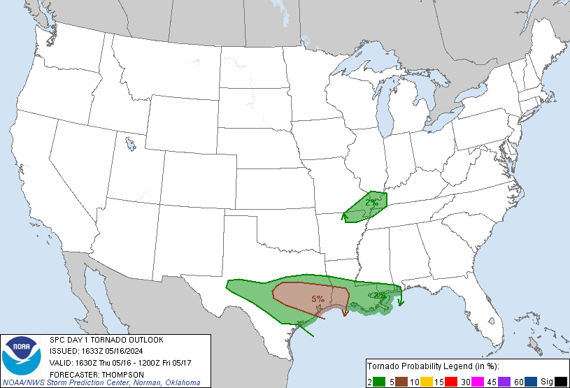
60% wind probs are pretty eye-popping. Not too often you see 60% anything (not sure what it'd take to see 60% tornado probs). 45% for us here. At the office until ~12:30 and then heading home after a lunch meeting.

April 7 2006 had a 60% TOR around the TN/MS/AL border for a couple outlooks, I think only time they ever went that high.

Very scary storms last night for sure. No doubt the most intense tornadoes of 2017 thus far.
 

xJownage

Member
Messages
570
Reaction score
604
Location
Jacksonville, Florida
April 7 2006 had a 60% TOR around the TN/MS/AL border for a couple outlooks, I think only time they ever went that high.

Very scary storms last night for sure. No doubt the most intense tornadoes of 2017 thus far.
good memory, although the day was comparatively a bust. It was a decent outbreak, but nothing worth a 60% hatched for tornadoes (4/27/11 was 45%, by comparison).
 

xJownage

Member
Messages
570
Reaction score
604
Location
Jacksonville, Florida
As for today's outlook, I've never seen the NWS shape an outlook based on such a small swath of strong wind for so long; it looks like a derecho prediction, basically.
 

Equus

Member
Messages
3,295
Reaction score
3,380
Location
Jasper, AL
Special Affiliations
  1. SKYWARN® Volunteer
Yep, except for Gallatin the April 7 event was rather benign. I recall staying up late expecting the apocalypse and getting a mild squall line with scattered brief touchdowns.
 

Bama Ravens

Member
Messages
1,210
Reaction score
656
Location
Morris, AL (Northern Jefferson County)
So the HRRR now has discrete cells forming ahead of the main line in north-central AL

3-1-2017-8-43-18-AM.jpg
 

Lori

Administrator
Staff member
Administrator
Moderator
Messages
1,035
Reaction score
653
Location
Vandiver, AL
Special Affiliations
  1. SKYWARN® Volunteer


warneagle

Member
Messages
3,788
Reaction score
3,381
Location
Arlington, VA
Special Affiliations
  1. SKYWARN® Volunteer
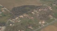
More damage out of Perryville.. oh boy.

Wow, could be talking about an EF3-EF4 rating on this one when all is said and done. Haven't seen many damage photos from the affected parts of IL yet.

It sure was eerie how closely that supercell paralleled the path of the Tri-State Tornado.
 

xJownage

Member
Messages
570
Reaction score
604
Location
Jacksonville, Florida
Wow, could be talking about an EF3-EF4 rating on this one when all is said and done. Haven't seen many damage photos from the affected parts of IL yet.

It sure was eerie how closely that supercell paralleled the path of the Tri-State Tornado.
That was literally the first thing I said when it touched down and started racing a large tornado across the area. Thankfully it wasn't as long; a nocturnal modern tri-state tornado would be nothing short of absolutely devastating.
 

Equus

Member
Messages
3,295
Reaction score
3,380
Location
Jasper, AL
Special Affiliations
  1. SKYWARN® Volunteer
And looks like they just pulled the enhanced further into AL.

Also yikes

day1probotlk_1630_torn_prt.gif
 

Kory

Member
Messages
4,928
Reaction score
2,119
Location
Tuscaloosa, Alabama
I'm noticing mesoscale models are under forecasting the low level helicity values. They're being driven more by speed shear (rapid increase in velocity with height) than directional shear (veering of the winds with altitude). Model progs were <200 m2/s2 0-1 km helicity....they're sitting at 300-350 m2/s2. Usually SW surface winds don't really work....but this argues something else....
 

WesL

"Bill, I'm talkin' imminent rueage"
Staff member
Administrator
Moderator
Sustaining Member
Messages
3,366
Reaction score
2,648
Location
Fayetteville, AR
Special Affiliations
  1. SKYWARN® Volunteer
 
Back
Top