

speedbump305
Member
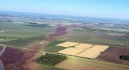
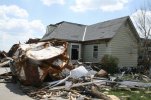
Incredible aerial view of the ground scar left by the 2026 Kouts, IN tornado.
Follow along with the video below to see how to install our site as a web app on your home screen.
Note: This feature may not be available in some browsers.

I mean the main round was the initial stuff people were thinking about. Prefrontals fired and off to the races they went.June 11th as a whole makes a very convincing argument for outbreak of the year, which is fitting because it exemplifies all the little tropes of the year.
-Conditional 15% cig 2
-Moning convection
-dependent on prefrontal cells firing
-boundary riding cells
-chaser convergence
-Illinois.
leave it to 2026 to finally verify a moderate with a highly conditional setup on one of the last big days of the season.
I’m not disputing that part of the event, it’s more that in the majority of the previous high-ceiling days, prefrontal convection was a major factor in whether or not those events hit their ceiling.I mean the main round was the initial stuff people were thinking about. Prefrontals fired and off to the races they went.

Idk if this is still being talked about, but both Appomattox and Tappahannock on this day were probably violent, doing a video essay about this day overall. But Tappahannock was a whole different breed of violence for VA and MD that I don't think has been matched Since La Plata 1926 or the Rye Cove outbreak. Additional images below of Tappahannock. The scar still exists today, with low-level vegetation like shrubbery and moss is permanently stunted, typical of extremely violent tors (London, Bassfield, and Canton experienced similar levels of ecosystem collapse for these species that have yet to return). The closest tornado to this is the HIGH END EF3 in Gloucester during the 2011 Carolinas outbreak, and if you drive through the areas today, the only way you're going to pick out is with an empty school lot. Definitely an interesting factor in all of this, considering that this storm, at the point, was entirely deep-layer shear-driven, as the area had been soaked in convective debris and cloud cover most of the day. This was a result of the floor of this setup.The 2016 Tappahannock VA EF3 tornado was likely violent. It annihilated forests and when the core passed over an open field it produced scouring.
View attachment 7988
View attachment 7989
View attachment 7990
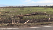
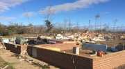
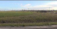
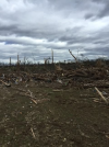
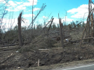
Both are pretty underrated tornadoes in terms of how often people don’t talk about them. They are very few videos on YouTube of the Appomattox tornado. As a relative close to the area that tornado probably had EF4 windsIdk if this is still being talked about, but both Appomattox and Tappahannock on this day were probably violent, doing a video essay about this day overall. But Tappahannock was a whole different breed of violence for VA and MD that I don't think has been matched Since La Plata 1926 or the Rye Cove outbreak. Additional images below of Tappahannock. The scar still exists today, with low-level vegetation like shrubbery and moss is permanently stunted, typical of extremely violent tors (London, Bassfield, and Canton experienced similar levels of ecosystem collapse for these species that have yet to return). The closest tornado to this is the HIGH END EF3 in Gloucester during the 2011 Carolinas outbreak, and if you drive through the areas today, the only way you're going to pick out is with an empty school lot. Definitely an interesting factor in all of this, considering that this storm, at the point, was entirely deep-layer shear-driven, as the area had been soaked in convective debris and cloud cover most of the day. This was a result of the floor of this setup. View attachment 55547View attachment 55548View attachment 55549View attachment 55550View attachment 55551
I would say mountainous terrain probably aids that area more often than people think. But that extreme SW VA area as far as i know, there has been very few major tornadoes in recorded history over there. Wonder if we will ever see the likes of a June 1944 type event over there, but that's a whole different story.Both are pretty underrated tornadoes in terms of how often people don’t talk about them. They are very few videos on YouTube of the Appomattox tornado. As a relative close to the area that tornado probably had EF4 winds
Same goes for Elon the same year. Another tornado that doesn’t get talked about enough, I was heading back from church when my parents and I saw it, and I had pointed it because it was completely rain wrapped and we saw it form.
The region around Lynchburg Appomattox Rustburg is a little mini hotspot for tornadoes.
People thought that area was pretty much immune and unable to get tornadoes because of the terrain. That outbreak is a reminder that it can happen, and it just so happen to be an F4 that hit Shinniston which is West Virginia’s only violent tornado in recorded history.I would say mountainous terrain probably aids that area more often than people think. But that extreme SW VA area as far as i know, there has been very few major tornadoes in recorded history over there. Wonder if we will ever see the likes of a June 1944 type event over there, but that's a whole different story.
Depends; I don't think the Appalachians are tall enough to hamper or improve tornado production as we see further west along the Pacific range and the Rockies. They're more akin to the Ozarks, which do frequently see violent tornado events, so whatever topographic effects exist probably matter more on stretching the vortex and constricting airflow, or aiding in lift. Can see plenty of Shenandoah Valley events where supercells set up on the Monongahela portion, or the Blue Ridge portion, or in more extreme forms, beds in significant tornado genesis always running up north through the valley.I would say mountainous terrain probably aids that area more often than people think. But that extreme SW VA area as far as i know, there has been very few major tornadoes in recorded history over there. Wonder if we will ever see the likes of a June 1944 type event over there, but that's a whole different story.

I have an update to this, it’s all but seemingly confirmed that this happened!A tornado transporting several, likely multi-ton tanks (that were full at the time) upwards of 7 miles is still hard to believe, and an indication of exceptional intensity in my opinion. It’s also worth mentioning that this is technically still my personal speculation and unofficial findings, as nothing has been definitively confirmed by any official sources to my knowledge, and I’m using available evidence I’ve located to come to this conclusion.
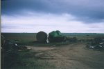

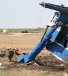

I have an update to this, it’s all but seemingly confirmed that this happened!
Came across a collection of photos posted on Flickr of damage to a farm south of Greensburg, with one of them having this description:
View attachment 55566View attachment 55567
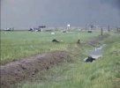
Although with my own personal research that traced the tanks in Greensburg to the area along Highway 183, it’s still insane to see this more-or-less confirmed. Here’s some additional photos I have documenting this.
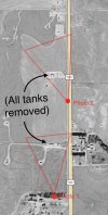
The first two photos are facing where the collections of oil storage tanks should be, with an aerial image to use as a reference.
View attachment 55568View attachment 55569View attachment 55570
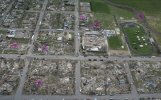
I’ve personally found approximately 8 tanks that wound up in Greensburg, with the majority circled in this aerial photo provided to me by Tim Marshall. One of these tanks reportedly had the words “came from 7 miles south,” spray painted on the side, which is what initially led me to track them down to the natural gas substations south of town.
View attachment 55571
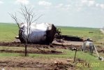
There's also a couple that landed on two seperate farms along Highway 183, one of them being the one pictured in the first image I attached, while the other is likely this one that landed on the farm across the road. For comparison, I attached an up close photo from Tim Marshall of one of the tanks that landed in Greensburg.
View attachment 55572
View attachment 55574
Again, to my knowledge, this is an extremely anomalous feat of tornado damage, and I’m not really sure what to compare it to in things we’ve seen from past high-end events.
Edit: I might reach back out to Tim and also NWS Dodge City and sort of ‘present’ my findings to see if anything comes out of it, or at least have it documented. On top of that, I’d like to somehow track down the oil company that the tanks belonged to and ask about this.

