• Welcome to TalkWeather!
    We see you lurking around TalkWeather! Take the extra step and join us today to view attachments, see less ads and maybe even join the discussion.
    CLICK TO JOIN TALKWEATHER

Discussion of April 27, 2011 Outbreak

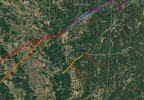
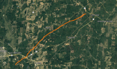
I genuinely cannot believe this tornado was missed; I've found 9.98 (basically 10) miles of verifiable damage corroborated with KGWX data from this singular tornado alone. Way to go MEG. It's getting to the length where I might have to try and find a photograph of it.
View attachment 54458
I'm really frusturated about this more than anything and re-sent it in to MEG with a bit of a more strongly-worded email given this absolutely should not be undocumented. It's not really their fault; I just don't know how a tornado of this length is unable to be confirmed.
Not really surprising that this is a MEG botch.

There is something structurally off with MEG as a whole. I’m not sure if it’s office culture, but the fact they’re still dropping the ball on anything to do with tornados 15 years later isn’t surprising. From forecasting and AFDs, to warnings and emergencies, to surveying, they are really below par.
 
Not really surprising that this is a MEG botch.

There is something structurally off with MEG as a whole. I’m not sure if it’s office culture, but the fact they’re still dropping the ball on anything to do with tornados 15 years later isn’t surprising. From forecasting and AFDs, to warnings and emergencies, to surveying, they are really below par.

I told them that if they don't want to do anything about it they can contact JAN who will gladly work on it:
1785855283055.png
I really want to see these tornadoes confirmed and the fact they happened in MEG's CWA is not helping anything at all. If they turn this one down a second time I might reach out to JAN directly. The vast majority of undocumented 4/27 tornadoes are 0.1-1 mile in length, not 10.
 
Question @Eoline. Was this tornado an entirely different one from the EF3 tornado from the first round that morning? I really haven't been following this thread a lot so that's why I'm curious
 
Question @Eoline. Was this tornado an entirely different one from the EF3 tornado from the first round that morning? I really haven't been following this thread a lot so that's why I'm curious
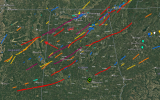
There isn't any tornado that day within 10 miles of the paths of these two (both the EF2 and EF3 are completely undocumented, as is the third EFU although I'm not convinced it's a tornado) which adds to the argument:
1785865553342.png
Ignore my Smithville and HPC paths lol. The closest is the New Wren EF3 later that day and a close second is the Trebloc EF3 from the morning. Both are >10 miles away though.
 
There isn't any tornado that day within 10 miles of the paths of these two (both the EF2 and EF3 are completely undocumented, as is the third EFU although I'm not convinced it's a tornado) which adds to the argument:
View attachment 54460
Ignore my Smithville and HPC paths lol. The closest is the New Wren EF3 later that day and a close second is the Trebloc EF3 from the morning. Both are >10 miles away though.
1785865722191.png
 
There isn't any tornado that day within 10 miles of the paths of these two (both the EF2 and EF3 are completely undocumented, as is the third EFU although I'm not convinced it's a tornado) which adds to the argument:
View attachment 54460
Ignore my Smithville and HPC paths lol. The closest is the New Wren EF3 later that day and a close second is the Trebloc EF3 from the morning. Both are >10 miles away though.
I see now. That is wild. What's your best timing for this one? Morning/afternoon? I'm trying to look back at radar data to see if there was any obvious rotation
 
I see now. That is wild. What's your best timing for this one? Morning/afternoon? I'm trying to look back at radar data to see if there was any obvious rotation
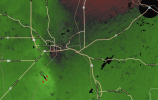
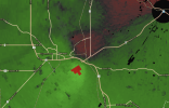
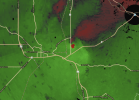
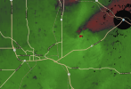
We actually have amazing radar data of it, 2011 considered! This was during the morning QLCS just west of KGWX:
1785866147574.png1785866157894.png1785866172109.png1785866192810.png
The 8:21 to 8:49 scans all have rotation; the first tornado touched down at exactly the 8:30 scan (second image) and lasted until around the 8:44 scan. Rotation picks back up at the 9:07 scan in Lamar County, AL but I'm yet to find coorelating damage. Honestly I wouldn't be surprised if the EF2 and EF3 were one long-tracked intense tornado.
 
Honestly I wouldn't be surprised if the EF2 and EF3 were one long-tracked intense tornado.
1785867179880.png
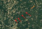
I'll need to look more into this but this would make it 12.3 miles long.
 
View attachment 54467
I'll need to look more into this but this would make it 12.3 miles long.
I've upped it to 14.40 miles; at this point I'm going to avoid spam-posting and will just update the spreadsheet I posted yesterday as I find stuff. The track continues further-west as well.
 
Back
Top