Kds86z
Member
Oh yeah. I saw that too. A bit historic June..yeah, another important stat is the last time the WPAC had a major in June was in 2012.
Follow along with the video below to see how to install our site as a web app on your home screen.
Note: This feature may not be available in some browsers.
Oh yeah. I saw that too. A bit historic June..yeah, another important stat is the last time the WPAC had a major in June was in 2012.
And there is alot more activity coming.Oh yeah. I saw that too. A bit historic June..
Honestly probably closer to typhoon now.We got Bavi now.
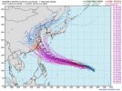
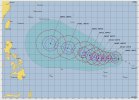
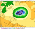
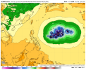
JUST IN: The Joint Typhoon Warning Center (JTWC) is now predicting Tropical Storm #Bavi to intensify into a Category 5 super typhoon on the US scale by Sunday, July 5, 2026, due to a possible rapid intensification (RI) phase that may begin within the next 24 hours.
They expect the system to peak at least 140 knots (~260 km/h) within the five-day forecast period, and during its passage in the Mariana Islands. For the official advisories, kindly check @NWSGuam.
Yeah, going to be a bad one.Honestly probably closer to typhoon now.
I’d be shocked if it ended up getting sub-880, but with all the factors lining up the way they are (WPAC in a pristine environment, July, model agreement), I think sub 900 is likely here.Some of the Euro Ensemble members from yesterday's 12z has near or at record low pressure with this and still do with today's 00z run. Might give Tip a run for it's money. If it was the GFS or Canadian showing it, I would have already thrown it out. However, since it's the Euro, it warrants more attention.
I wish we didn't just fully rely on satellite for pressure readings for West Pacific storms now.
Not at all. Only reason we know of Tip's 870mb record pressure is because recon flew thru it multiple times (60 times). I'm quite sure though that pressure has been beaten since then, but we'll never officially know by like Patricia, Haiyan, etc. Granted, you had recon in Patricia, but they had to leave it before they could get a better reading.I’d be shocked if it ended up getting sub-880, but with all the factors lining up the way they are (WPAC in a pristine environment, July, model agreement), I think sub 900 is likely here.
Is it unreasonable of me to be a little skeptical of a lot of those storms’ intensities and pressures from 1960-1980 in the WPAC?
yeah when a cane is too strong noaa just says, "peace" and avoids it which makes sense I'd rather have decent data than perfect data for 2s then disasterNot at all. Only reason we know of Tip's 870mb record pressure is because recon flew thru it multiple times (60 times). I'm quite sure though that pressure has been beaten since then, but we'll never officially know by like Patricia, Haiyan, etc. Granted, you had recon in Patricia, but they had to leave it before they could get a better reading.
Right! And see there in lies the case for unmanned drones being usedyeah when a cane is too strong noaa just says, "peace" and avoids it which makes sense I'd rather have decent data than perfect data for 2s then disaster

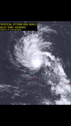
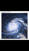
Yeah, it is about to undergo a period of explosive intensification. It has that classic HE Cat 1-LE Cat 2 look to it.View attachment 54029
Bavi really looks like it wants to go crazy.
Sorry if this attachment is large, I’m on mobile right now and it’s hard to tell if this is too big or not.
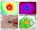
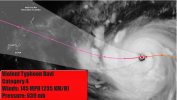
Much stronger now, 125 kt Cat 4.@ Cat 2
Fast…. !Much stronger now, 125 kt Cat 4.