
Good luck and be safe! Lots of hills up there.Cancelled my plans to drive out to North Alabama to chase. With how things are looking in the Atlanta area, I might as well save the money, and wear and tear on my body, and observe what happens here at home. Trey pointed it out in his latest update, but there's increasing concern about the area from Atlanta to the Florida Panhandle for a localized elevated area of tornado potential, and I'll probably focus on that. Just hate that it'll be moving through in the early morning hours.
Navigation
Install the app
How to install the app on iOS
Follow along with the video below to see how to install our site as a web app on your home screen.
Note: This feature may not be available in some browsers.
More options
-
Welcome to TalkWeather! We see you lurking around TalkWeather! Take the extra step and join us today to view attachments, see less ads and maybe even join the discussion. CLICK TO JOIN TALKWEATHER
You are using an out of date browser. It may not display this or other websites correctly.
You should upgrade or use an alternative browser.
You should upgrade or use an alternative browser.
Severe Weather 3/15 - 3/16
- Thread starter CheeselandSkies
- Start date
Kds86z
Member
Justin Hindman
Member
- Messages
- 378
- Reaction score
- 1,165
- Location
- Gardendale Alabama
- Special Affiliations
- SKYWARN® Volunteer
- ARRL Member
Debating on going to Memphis tomorrow or not, if it’s just gonna be a line, no point, if there is any chance of supercells, it would be worth it
bckhd2
Member
Has the threat increased in the Atlanta area? I’ve been working Little League all day and haven’t had a chance to check any of the model updates. I saw the SPC extended the Slight risk to the Metro though.Cancelled my plans to drive out to North Alabama to chase. With how things are looking in the Atlanta area, I might as well save the money, and wear and tear on my body, and observe what happens here at home. Trey pointed it out in his latest update, but there's increasing concern about the area from Atlanta to the Florida Panhandle for a localized elevated area of tornado potential, and I'll probably focus on that. Just hate that it'll be moving through in the early morning hours.
tennessee storm chaser
Member
- Messages
- 1,877
- Reaction score
- 4,288
- Location
- jackson tennessee
- Special Affiliations
- SKYWARN® Volunteer
I chase there a lot Justin pretty flat for Tennessee in that area. Sure you been there. . I amDebating on going to Memphis tomorrow or not, if it’s just gonna be a line, no point, if there is any chance of supercells, it would be worth it
Jackson just 85 miles east of Memphis . Where I start at for me. There decent chance we get some pre cell out front of the squall . Interesting day shaping up tomorrow
Stick closer to home, in that case - better chances for that will be in Alabama.Debating on going to Memphis tomorrow or not, if it’s just gonna be a line, no point, if there is any chance of supercells, it would be worth it
tennessee storm chaser
Member
- Messages
- 1,877
- Reaction score
- 4,288
- Location
- jackson tennessee
- Special Affiliations
- SKYWARN® Volunteer
Trimmer still thinks Memphis area aroundStick closer to home, in that case - better chances for that will be in Alabama.
North ms. Hot spot overall
WeathermanLeprechaun
Member
Gabe Garfield saying this makes me feel uneasy. 18z HRRR does tend to suggest some thermodynamic issues that may prevent a more potent sigtor threat but I'll take his word for it
speedbump305
Member
Gabe is normally one I always trust. He does not normally hyperbolize any forecast and is always genuine with what he thinks may happen. So Monday may end up being a pretty big day.Gabe Garfield saying this makes me feel uneasy. 18z HRRR does tend to suggest some thermodynamic issues that may prevent a more potent sigtor threat but I'll take his word for it
Is he mowing that area tomorrow?Trimmer still thinks Memphis area around
North ms. Hot spot overall
The rule of thumb I’ve always followed is CAMs within 24 hours. I’ve seen them flip back and forth far too many times over the years in that 2-4 day range. 3/14/25 was a great example of that last year. The CAMs really didn’t have a good handle on the discrete storm mode until that morning. A lot of it just comes down to getting actual sampling of the system as it comes on shore and get that data ingested into the models.Gabe Garfield saying this makes me feel uneasy. 18z HRRR does tend to suggest some thermodynamic issues that may prevent a more potent sigtor threat but I'll take his word for it
WeathermanLeprechaun
Member
Oh, i agree. I think I'll stick with the NAM for now until we get closer although I'm not gonna die on a hill with the NAM. It suggests a potentially high end solution and i don't think it's out of the question for Monday to be a major day.Is he mowing that area tomorrow?
The rule of thumb I’ve always followed is CAMs within 24 hours. I’ve seen them flip back and forth far too many times over the years in that 2-4 day range. 3/14/25 was a great example of that last year. The CAMs really didn’t have a good handle on the discrete storm mode until that morning. A lot of it just comes down to getting actual sampling of the system as it comes on shore and get that data ingested into the models.
Quick Ted talk here: I noticed a lot on certain YT streams saying prefrontals weren't likely due to CAMs. It is notoriously known CAMs can be really unusual at the start of their range as they begin to juggle the setup with their several biases.
But CAMs aren't how you forecast prefrontals. You look for convergence zones evident ahead of the line, favorable thermodynamics so that cells can rise.
Too many relying on CAMs when the very man that forecasted a major tornado outbreak when CAMs shifted the general perspective of people only used ECMWF simref and a few other parameters to come to the agreement of "There's gonna be OWS convection"
Monday CONTINUES to look like a potentially high end day regardless of what CAMs say right now.
tennessee storm chaser
Member
- Messages
- 1,877
- Reaction score
- 4,288
- Location
- jackson tennessee
- Special Affiliations
- SKYWARN® Volunteer
Agree 100 percent. Not sure when his latest plans goIs he mowing that area tomorrow?
The rule of thumb I’ve always followed is CAMs within 24 hours. I’ve seen them flip back and forth far too many times over the years in that 2-4 day range. 3/14/25 was a great example of that last year. The CAMs really didn’t have a good handle on the discrete storm mode until that morning. A lot of it just comes down to getting actual sampling of the system as it comes on shore and get that data ingested into the models.
Out ….think short range over
Night will be very I lmportant in getting a better idea
KevinH
Member
It would be nice if people tweeted an entire picture so people can see the forecast details, the legend, etc instead of just cropping all of it out.
(Not you @TheSuckZone lol. I know this isn't your tweet)
Ozonelayer
Member
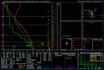
Be sure to turn that magnet off lol18z 3km NAM sounding right over my house valid at 8pm Sunday
I was blown away when I saw Broyles do that for 4/2 last year.Too many relying on CAMs when the very man that forecasted a major tornado outbreak when CAMs shifted the general perspective of people only used ECMWF simref and a few other parameters to come to the agreement of "There's gonna be OWS convection"
WeathermanLeprechaun
Member
Honestly not seeing prefrontal convection tomorrow due to a few factors
Even if we do manage to reach 1k SBCAPE tmrw towards that AR/MS/TN border vicinity, i think a sharp warm nose will quickly erode any potential of prefrontals. Regardless, there's still major QLCS potential for significant damaging winds and dozens of QLCS spinups.
I feel like prefrontal convection overall has became heavily less likely with overnight tomorrow but I still expect a potent QLCS event.
I still remain confident in potential prefrontals 4am Monday in SE AL when CAPE increases enough to where that warm nose wouldn't necessarily kill off any updraft but they may need a few boosts to truly mature. A few tornadoes easily possible with this activity.
18z NAM is genuinely impressive. Plenty of instability and volatile shear, combined with large amounts of low level instability in S VA. This has been a wildly consistent trend from the NAM.
WeathermanLeprechaun
Member
Yep, me too. Proves that there is always different ways to sneak out a event and he found the key to 4/2 before any others. I heavily doubt the RRFS was even part of his forecast nor did he even recognise it as a validation of his thinking. Just a brilliant forecastI was blown away when I saw Broyles do that for 4/2 last year.
Yep, last year's 3/14 and 3/15 very much comes to mind on opposite ends of the CAM-ification spectrum. Generally I like to think of them as very useful to get an idea of what things might look like, but basically advise never using them as anything remotely approaching gospel until within that 18-24 hour range.The rule of thumb I’ve always followed is CAMs within 24 hours. I’ve seen them flip back and forth far too many times over the years in that 2-4 day range. 3/14/25 was a great example of that last year. The CAMs really didn’t have a good handle on the discrete storm mode until that morning. A lot of it just comes down to getting actual sampling of the system as it comes on shore and get that data ingested into the models.
Even when depicted on CAMs, prefrontal cells seem to occur fairly rarely in setups like this, and when they do occur, they often tend to just bop around at sub-severe levels until they get eaten by the QLCS. Definitely possible, but I feel like the wording of some WFOs and forecasters that strong tornado potential in the eastern MS into AL/GA region hinges on prefrontals is perhaps a bit misleading - I think there is very much significant tornado potential across the area, but I find it far more likely to come from the QLCS itself than from discrete cells. Not completely discounting the possibility either, I think it could still happen, but it isn't my primary concern. The belief that QLCS tornadoes can't be strong is a weirdly-persistent belief that seems to bias even people who know better, so a lack of discrete convection doesn't make me any less watchful.Honestly not seeing prefrontal convection tomorrow due to a few factors
Even if we do manage to reach 1k SBCAPE tmrw towards that AR/MS/TN border vicinity, i think a sharp warm nose will quickly erode any potential of prefrontals. Regardless, there's still major QLCS potential for significant damaging winds and dozens of QLCS spinups.
I feel like prefrontal convection overall has became heavily less likely with overnight tomorrow but I still expect a potent QLCS event.
I still remain confident in potential prefrontals 4am Monday in SE AL when CAPE increases enough to where that warm nose wouldn't necessarily kill off any updraft but they may need a few boosts to truly mature. A few tornadoes easily possible with this activity.
18z NAM is genuinely impressive. Plenty of instability and volatile shear, combined with large amounts of low level instability in S VA. This has been a wildly consistent trend from the NAM.