
Navigation
Install the app
How to install the app on iOS
Follow along with the video below to see how to install our site as a web app on your home screen.
Note: This feature may not be available in some browsers.
More options
-
Welcome to TalkWeather! We see you lurking around TalkWeather! Take the extra step and join us today to view attachments, see less ads and maybe even join the discussion. CLICK TO JOIN TALKWEATHER
You are using an out of date browser. It may not display this or other websites correctly.
You should upgrade or use an alternative browser.
You should upgrade or use an alternative browser.
Severe Weather 3/15 - 3/16
- Thread starter CheeselandSkies
- Start date
tennessee storm chaser
Member
- Messages
- 1,877
- Reaction score
- 4,288
- Location
- jackson tennessee
- Special Affiliations
- SKYWARN® Volunteer
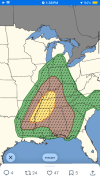
Big 10
Percent hatched tornado now
Percent hatched tornado now
KevinH
Member
AFD just issued from BMX:
Area Forecast Discussion
National Weather Service Birmingham AL
1240 PM CDT Sat Mar 14 2026
...New DISCUSSION, AVIATION...
.KEY MESSAGES...
Updated at 1239 PM CDT SAT MAR 14 2026
- There is a medium to high chance for severe weather Sunday
night into Monday morning. There's increasing concern for
widespread damaging winds and a few tornadoes.
- There is a very high chance (>90%) for freezing temperatures
Tuesday and Wednesday mornings for all of Central Alabama.
&&
.DISCUSSION...
(This afternoon through Friday)
Issued at 1239 PM CDT SAT MAR 14 2026
Severe weather is expected Sunday night into Monday morning.
A deep trough with a strong low pressure system is expected to slide
through the Central US and push a cold front into Central Alabama.
We're expecting a line of storms to move quickly along that frontal
boundary. Widespread damaging wind appears to be the highest threat;
however, strong low level and deep layer shear will certainly raise
the potential for a few embedded tornadoes with this line.
Currently, the lines of storms is expected to move into Central
Alabama around 9pm - 11pm and exit the region to our southeast by 6-
7 am Monday morning.
Intability doesn't appear to be as much of an uncertainty as it has
been in the past few days. Latest model trends have become more
consistent with anywhere between 700-1200 J/kg of surface-based
CAPE. Given the strong dynamics and strong low level jet, this
should easily be able to support the severe storms that are shown,
along with supporting embedded tornadoes.
Monday will be much colder just after this cold front moves through.
Monday daytime highs are only expected to top out in the 40s for
most locations. A widespread freeze is expected Tuesday morning and
Wednesday morning with at least a low to medium chance for a hard
freeze for some of our colder locations across the north on Tuesday
morning. Broad high pressure builds across the region for the
remainder of next week, keeping Central AL rain free and moderating
to more seasonable temperatures as we go through the second half of
the week.
25/Owen
speedbump305
Member
I wouldn’t be surprised to maybe see a moderate issued tomorrow. They seem to be gaining confidence more and more about the tornado threat for tomorrow.
Definitely room for Level 4 risk especially given the 10% TOR and 45% WIND now
akt1985
Member
Some schools are off for Spring Break. However, with a high chance of robust severe weather late Sunday night into early Monday morning, I bet a lot of school systems will have to decide if school can start on time or be delayed or even cancelled.
KevinH
Member
and an even LARGER CIG1Big 10
Percent hatched tornado now
Kds86z
Member


KakashiHatake2000
Member
Also there is a 15% cig one bi hail risk issued as well
KevinH
Member
I had that same thought. So I had to look at their conversion chart for the risk categories lol. The circled area is where we are for TOR as of this last update. For a MOD, they would have to increase the TOR risk a couple of notches to CIG1 30%, or CIG2, 15%. Pick your poison. I am not staying up for the next D2 update haI wouldn’t be surprised to maybe see a moderate issued tomorrow. They seem to be gaining confidence more and more about the tornado threat for tomorrow.

Last edited:


KevinH
Member
For those of you wondering about when Outlooks are issued:
Here is a conversion table.
During EDT (Mar - Nov), I take the "Z" time and subtract 4 (for Eastern time). The next D2 update is scheduled for 1730Z. 1730 - 4 hours = 1330. This is now military time). Then I convert that military time to regular time... 1330 - 1:30PM EDT
For CDT, you would subtract 5 hours instead of 4.... So 1730Z - 5 hours = 1230.... 1230pm CST
During STANDARD time (Nov - Mar), you would increase the hour you subtract by one. So Eastern would be -5 and Central would be -6 hours.
View attachment 51800
ALSO....if you go to the SPC Convective Outlooks: Days 1–8 page, scroll down to "Convective Outlook Issuance Times", and hover your mouse over each of the times they have, it will SHOW you what time that outlook is released in your timezone
")


Ozonelayer
Member
Been watching trends sporadically throughout the day, and both days have the potential and even likelihood (if trends continue) to increase both days to a MDT, both for tornadoes and wind.
Tomorrow has (atleast to me) trended toward a more embedded supercell/semi-discrete line from the MS/TN border southwards, and potentially even more north than that. Prefrontals also might happen but thats less certain. Given the environment at play in the deep south and increasing moisture/CAPE trends, a CIG2 for tornadoes seems possible and I wouldn't rule out a small 15% CIG2.
For Monday, the increasing CAPE and lack of a stout cap increses confidence (atleast for me) for prefontal discrete supercells infront of a broken/semi-discrete line. The environment at play is suprisingly high end for the mid atlantic and the potential several intense tornadoes exists in my eyes. The day 2 outlooks should be interesting for monday.
speedbump305
Member
I think Monday has the better shot for discrete pre frontals. But tomorrow definitely shouldn’t be slept on for pre frontals either because if one can get itself together along the MS/TN border, it could get intense.Been watching trends sporadically throughout the day, and both days have the potential and even likelihood (if trends continue) to increase both days to a MDT, both for tornadoes and wind.
Tomorrow has (atleast to me) trended toward a more embedded supercell/semi-discrete line from the MS/TN border southwards, and potentially even more north than that. Prefrontals also might happen but thats less certain. Given the environment at play in the deep south and increasing moisture/CAPE trends, a CIG2 for tornadoes seems possible and I wouldn't rule out a small 15% CIG2.
For Monday, the increasing CAPE and lack of a stout cap increses confidence (atleast for me) for prefontal discrete supercells infront of a broken/semi-discrete line. The environment at play is suprisingly high end for the mid atlantic and the potential several intense tornadoes exists in my eyes. The day 2 outlooks should be interesting for monday.
Oh wow. Did not expect that expansion. Definitely feel like there's potential for the southeast first moderate of the year.
KevinH
Member
Look at the EFFECTIVE SRH values for this NAM run:
 www.eas.slu.edu
Lots of 300s and 400s during the period, as well as 500 once (in central TN).
For those wondering about SRH (Storm Relative Helicity):
Critical values of SRH (Storm Relative Helicity) for tornadic development, as researched in North America,[3] are:
SRH = 150-299 ... supercells possible with weak tornadoes according to Fujita scale
SRH = 300-499 ... very favourable for supercell development and strong tornadoes
SRH > 450 ... violent tornadoes
I would like to know where I can find EHI values lol
CIPS Model Guidance
Lots of 300s and 400s during the period, as well as 500 once (in central TN).
For those wondering about SRH (Storm Relative Helicity):
Critical values of SRH (Storm Relative Helicity) for tornadic development, as researched in North America,[3] are:
SRH = 150-299 ... supercells possible with weak tornadoes according to Fujita scale
SRH = 300-499 ... very favourable for supercell development and strong tornadoes
SRH > 450 ... violent tornadoes
I would like to know where I can find EHI values lol
I'm just wondering if we see the usual uptick the close range HRRR likes to do as we get closer to Sundays eventI think Monday has the better shot for discrete pre frontals. But tomorrow definitely shouldn’t be slept on for pre frontals either because if one can get itself together along the MS/TN border, it could get intense.
KevinH
Member
Is the HRRR in the room with us?I'm just wondering if we see the usual uptick the close range HRRR likes to do as we get closer to Sundays event
I am trying to look for it (online lol)
KevinH
Member
@UncleJuJu98 I found this on Pivotal:I'm just wondering if we see the usual uptick the close range HRRR likes to do as we get closer to Sundays event

That track in Central E AL/W GA goes right through my county