
Just to be clear, you're talking about Monday, right, not Sunday? Thanks and I'm also curious as to what your method is somewhatMy method has breached 110-120 on some soundings from the NAM on this day.
120 and above is usually intense tornado potential.... That's why I'm sounding this day out a lot. I just feel like people are not paying attention enough to it. There is very dangerous potential if things align for it
Navigation
Install the app
How to install the app on iOS
Follow along with the video below to see how to install our site as a web app on your home screen.
Note: This feature may not be available in some browsers.
More options
-
Welcome to TalkWeather! We see you lurking around TalkWeather! Take the extra step and join us today to view attachments, see less ads and maybe even join the discussion. CLICK TO JOIN TALKWEATHER
You are using an out of date browser. It may not display this or other websites correctly.
You should upgrade or use an alternative browser.
You should upgrade or use an alternative browser.
Severe Weather 3/15 - 3/16
- Thread starter CheeselandSkies
- Start date
KevinH
Member
People in the south and everywhere have to be aware these days. Even if people ARE made aware, that does not mean they will take it as seriously as they should. News stations can do what they can though. EEEEEEEEVEEYONE should have a weather radio and MULTIPLE ways of receiving alerts 24/7.My method has breached 110-120 on some soundings from the NAM on this day.
120 and above is usually intense tornado potential.... That's why I'm sounding this day out a lot. I just feel like people are not paying attention enough to it. There is very dangerous potential if things align for it
Most people are not weather aware or as watchful as we are and are not going to take the weather seriously unless and until they get some sort of confirmation first (ears propping, windows blown, visual confirmation, lights flickering, etc).
Sadly, a lot of people (over the next few years) are going to have to learn the hard way.
Too many people think something CANT happen to them... until it does
 That kind of mentality takes peoples lives.
KakashiHatake2000
Member
I have heard that we probably won’t get a mayfield tornado for a long long time or while but let it be over open fields without any of the sort of devastation that night brought with that supercell and also the two other supercells
KevinH
Member
Be careful using the "s" (sequence) word here... a lot of people think of a "tornado outbreak sequence" when they read that.Something that I want to mention is that, for my area at least (middle Tennessee), the forecast suggested that after the storms come through Sunday night, the temperatures could cool into the 30s and potentially even create a chance for snowfall in the vicinity. In addition, low temperatures will also be plunging into the 10s to lower 20s on Monday night, with highs struggling to climb into the 40s/50s into Wednesday.
All in all, it seems like tomorrow and Monday are shaping up to be a rather “interesting” two-day sequence. Let’s pray that it won’t be in the “Chinese curse” sense of the word.
Two day EVENT might be better to say lol
WeathermanLeprechaun
Member
Sorry, bit sleepy right now but yes, Monday. The method is still WIP and I'm trying to find a way so the method doesn't get tripped up by hail sounding. It'll probably be a WIP for a while as I continue to tweak itJust to be clear, you're talking about Monday, right, not Sunday? Thanks and I'm also curious as to what your method is somewhat
A short list of how it works
SBCAPE (whether 1k and up above, divide by 100. Must round the level of SBCAPE. Say if 3,000 SBCAPE, it goes down to 30)
3CAPE matters too and I divide that by 10, so if it breaches 100, that's 10 and the more and more, you get the idea.
I combine 0-1km and 0-6km shear.
The method accounts for storm mode, so if linear, i remove 30 off the calculation when all done.
When I tested this on the Dickens sounding from June 16th or at least one from the HRRR, my method managed to detect this tornado amazingly with a 130 on the method. I have high hopes i could potentially call out a sneakier intense tornado event this year by using this method cautiously. I could explain it better tomorrow but it's just really a experimental method. On 3/14 last year, it was 150-160, which is at the top of the scale with 4/27, 4/3, and Palm Sunday.

KakashiHatake2000
Member
I don’t know why but it seems like people “bleep” out that winter precip word it makes me want to say it in all capital letters
N0mz
Member
Monday is definitely one of those events that STP underestimates because it has (IMO) a CAPE bias. Ignore the LCL and CIN components here, since most MDT+ risks already cover them pretty well. EBWD is a measure of bulk shear.
For example, Monday has 300 ESRH and 60 EBWD widespread, although CAPE is in the low 1000s. However, this would rate about the same as a setup with 4500 ML, 100 ESRH, and 30 EBWD. In my experience, the first setup performs much better than the second. i.e., the big time SRH events with just adequate CAPE are usually much more dangerous than the CAPE bomb with low-moderate shear.

For example, Monday has 300 ESRH and 60 EBWD widespread, although CAPE is in the low 1000s. However, this would rate about the same as a setup with 4500 ML, 100 ESRH, and 30 EBWD. In my experience, the first setup performs much better than the second. i.e., the big time SRH events with just adequate CAPE are usually much more dangerous than the CAPE bomb with low-moderate shear.
Hence why it's not usually the best thing to rely on to keep tabs on tornado setups in the Southeast. A few hundred j/kg can be enough to produce tornadoes, and 1,000+ is very healthy by Dixie standards.Monday is definitely one of those events that STP underestimates because it has (IMO) a CAPE bias. Ignore the LCL and CIN components here, since most MDT+ risks already cover them pretty well. EBWD is a measure of bulk shear.
For example, Monday has 300 ESRH and 60 EBWD widespread, although CAPE is in the low 1000s. However, this would rate about the same as a setup with 4500 ML, 100 ESRH, and 30 EBWD. In my experience, the first setup performs much better than the second. i.e., the big time SRH events with just adequate CAPE are usually much more dangerous than the CAPE bomb with low-moderate shear.
View attachment 51820
Yes a few hundred is sufficient especially considering we are in March, not in AprilHence why it's not usually the best thing to rely on to keep tabs on tornado setups in the Southeast. A few hundred j/kg can be enough to produce tornadoes, and 1,000+ is very healthy by Dixie standards.
Kds86z
Member
Kds86z
Member
Oh no for me. I am still watching and waiting with concern.
Kds86z
Member
Biggest east coast threat I’d say since Easter 2020 outbreak.? Idk .Oh no for me. I am still watching and waiting with concern.
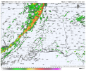
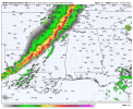
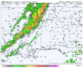
Very interesting how the 00z HRRR, RRFS, and 3km NAM all have the line of storms moving thru North MS by 9pm. The 3km NAM gives hints of potential for storms out ahead of the main line.
Attachments
Kds86z
Member
N0mz
Member
So, are we thinking D2 moderate tonight? I feel like it's coming at least by the 1730z outlook, assuming the current setup holds, but not sure about tonight.
A comparison of 00Z CAMs, including the experimentals. From a glance, I think ARW might have the best handle on the situation for the Monday portion of the event. Areas favored across the models include the 1) MS/AR/TN triple-point across MS into AL, 2) northern/central Alabama into Georgia, and 3) central Georgia into the Carolinas.


Kds86z
Member
Actually for me in Southern PennsylvaniaBiggest east coast threat I’d say since Easter 2020 outbreak.? Idk .
the last mdt risk for me for tornadoes was 2008. It only failed because of some dry air in atmosphere. The whole week had tornadoes or tornado outbreak every day. No B%**. My area was the first B$&@. Good thing I guess.
Or was it 2003, hmmm I just remember a full week of 100-200 tornadoes all over leading up to the Sunday I had the risk.
N0mz
Member
Not sure if anyone mentioned, but the 00z NAM is a pretty wild run. The warm sector is much wider, and the moisture plume gets well into Pennsylvania at 18z. Probably the best run yet.
