
Navigation
Install the app
How to install the app on iOS
Follow along with the video below to see how to install our site as a web app on your home screen.
Note: This feature may not be available in some browsers.
More options
-
Welcome to TalkWeather! We see you lurking around TalkWeather! Take the extra step and join us today to view attachments, see less ads and maybe even join the discussion. CLICK TO JOIN TALKWEATHER
You are using an out of date browser. It may not display this or other websites correctly.
You should upgrade or use an alternative browser.
You should upgrade or use an alternative browser.
Severe Weather 3/9 - 3/12
- Thread starter CheeselandSkies
- Start date
Kds86z
Member
Yeah I haven’t been sleeping much. I meant like on Wiki when they group like 2 or 3 days into an outbreak page. So the last couple days will be one total outbreak.Ok.. tornado outbreak and tornado sequence are two different things, but I got ya lol
Kds86z
Member
Looks like a TOG west of Lucedale. The line has really strengthened in the last 15 minutes.
KevinH
Member
And it's here... I'm going to bed lol 40/20 probs

Kds86z
Member
Snipeslayer
Member
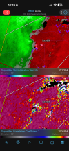
As someone who is learning still, what does the - -15 - - circled area around Columbus, GA represent just to the east of the primary discussion area of this graphic?
Kds86z
Member
Not sure tbh.As someone who is learning still, what does the - -15 - - circled area around Columbus, GA represent just to the east of the primary discussion area of this graphic?
Snipeslayer
Member
Thanks, I couldn't see anything particularly special outside of a popup of cape in that area?Not sure tbh.
Attachments
Kds86z
Member
Kds86z
Member
I see the DP and temps etc but not sure what that isThanks, I couldn't see anything particularly special outside of a popup of cape in that area?
Equus
Member
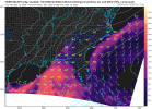
Storms look weaker from MOB now, but worth noting the beam is very attenuated right now as the storms pass over the radar site these last several scans; worth waiting to see what they look like in 15-30 minutes to see if they've really wound down that much
I could be wrong, but the more I look at the damage pics, the more I think the Aroma Park/Lake Village tornado will be likely be finalized as an EF3. The most impressive thing about it was the “explosive” debris pattern/wind rowing in Lake Village, but the foundation of the main house in question there appears to have been completely unreinforced CMU, meaning it likely came apart underneath whatever anchor bolts were present. This kind of structural failure makes the bolts essentially useless. While it’s not impossible for CMU foundation homes to be rated EF4, you almost always need some degree of reinforcement, or other evidence indicating that the CMU foundation held together at least somewhat well in order for EF4 to be assigned. Without additional contextual support besides the impressive debris pattern, I don’t really see how an upgrade could be justified. We shall see though.
Last edited:
N0mz
Member
850 mb tempsAs someone who is learning still, what does the - -15 - - circled area around Columbus, GA represent just to the east of the primary discussion area of this graphic?
WeathermanLeprechaun
Member
Never mind. With a potentially significant tornado from the QLCS last night, my method did do well after all. Nice verificationMy method struggles with methods that have poor low level shear but strong mid levels. As a result, I will tag any estimate on days like this as heavily conditional. Today, it reached 100 and that matches significant tornadoes. Clearly not verifying due to inversion and lack of strong low level shear at play.
Regardless, the tor threat will probably pick up soon
WeathermanLeprechaun
Member
QLCS spam right now in SE AL. Line orientation is SPINNING.


WeathermanLeprechaun
Member
Man, im heading to school in a min but this is ridiculous to watch. QLCS spam truly AR its craziest
It's extending up through Georgia, too. Velocity is really borked this morning for some reason, but hints of rotation visible around Tyrone, for example, which has prompted SVR with Tornado Possible tag.Man, im heading to school in a min but this is ridiculous to watch. QLCS spam truly AR its craziest


KevinH
Member
Watch it!
