
Navigation
Install the app
How to install the app on iOS
Follow along with the video below to see how to install our site as a web app on your home screen.
Note: This feature may not be available in some browsers.
More options
-
Welcome to TalkWeather! We see you lurking around TalkWeather! Take the extra step and join us today to view attachments, see less ads and maybe even join the discussion. CLICK TO JOIN TALKWEATHER
You are using an out of date browser. It may not display this or other websites correctly.
You should upgrade or use an alternative browser.
You should upgrade or use an alternative browser.
2/19/26- 2/20/26 - severe threat discussion
- Thread starter WeathermanLeprechaun
- Start date
Kds86z
Member
- Thread starter
- #23
WeathermanLeprechaun
Member
nah. This is Midwest focused.'Nother high shear low cape squall for Alabama and Mississippi with a few spin ups?
Subsidence is the major problem with this risk in IL/IN. Very warm 500 mb temperatures are becoming evident regardless of the cool bias from the NAM. People are putting too much credit into the RRFS with this, It's been bullish and several models have depicted this stubborn height falls scenario. Instability could uptrend but even the SPC said cells may not produce LIGHTNING despite the slight risk. Extremely unusual setup. And things are looking pretty conditional with this risk being honest if such warm air aloft continues with a lack of good moisture return.
Kds86z
Member
Yeah agree. Leaning into RRFSnah. This is Midwest focused.
Subsidence is the major problem with this risk in IL/IN. Very warm 500 mb temperatures are becoming evident regardless of the cool bias from the NAM. People are putting too much credit into the RRFS with this, It's been bullish and several models have depicted this stubborn height falls scenario. Instability could uptrend but even the SPC said cells may not produce LIGHTNING despite the slight risk. Extremely unusual setup. And things are looking pretty conditional with this risk being honest if such warm air aloft continues with a lack of good moisture return.
Kds86z
Member
Hot off the press latest d3:
..LOWER/MIDDLE OHIO VALLEY
AHEAD OF THE COLD FRONT, A PREFRONTAL TROUGH/PSEUDO DRYLINE IS
EXPECTED TO BE THE FOCUS FOR CONVECTIVE DEVELOPMENT DURING THE
AFTERNOON. THE DEGREE/QUALITY OF MOISTURE RETURN AHEAD OF THIS
FEATURE WILL BE KEY IN TERMS OF THE OVERALL MAGNITUDE OF THE SEVERE
THREAT. CURRENT OBSERVATIONS (TUESDAY) FROM SOUNDINGS DEPICT A VERY
MODEST MOIST LAYER ALONG THE GULF COAST. A MODEST SHORTWAVE TROUGH
ON TUESDAY NIGHT INTO WEDNESDAY WILL LIFT NORTHWARD TOO QUICKLY FOR
MORE SUBSTANTIAL MOISTURE RETURN. THE SURFACE PATTERN ON THURSDAY
WILL BE MORE ROBUST, BUT DEEPER MOISTURE MAY STILL NOT REACH FAR
ENOUGH NORTH GIVEN THAT MID 60S F DEWPOINTS ARE ONLY AS FAR NORTH AS
THE CENTRAL GULF CURRENTLY. GUIDANCE SUGGESTS MID TO UPPER 50S F
DEWPOINTS ARE MOST PROBABLE, WHICH DOES SEEM REASONABLE. THAT SAID,
TEMPERATURES ALOFT WILL NOT BE OVERLY COLD AND LAPSE RATES WILL NOT
BE OVERLY STEEP. THIS WILL LEAD TO CONVECTION THAT MAY REMAIN
SOMEWHAT LOW TOPPED IN NATURE. DESPITE LIMITING FACTORS WITHIN THE
ENVIRONMENT, 40-50 KTS OF EFFECTIVE SHEAR ROUGHLY PERPENDICULAR TO
THE BOUNDARY WILL FAVOR DISCRETE STORMS. LOW-LEVEL FLOW WILL BE
INCREASING WITH TIME AS WELL. SUPERCELLS CAPABLE OF FEW TORNADOES,
DAMAGING WINDS, AND ISOLATED LARGE HAIL ARE POSSIBLE DURING THE
AFTERNOON/EVENING.
..WENDT.. 02/17/2026
I think something interesting to note, is cips is rather high on Tennessee for this event. A bit of southern shift into the Tennessee valley could occur.

Last edited:
- Thread starter
- #27
WeathermanLeprechaun
Member
18z HRRR came in and imo, the best target is SE IL/SW IN. Problem is that it depicts a robust warm nose and poor 500s, which would mean likely no storm development. I would closely watch trends though. NAM has been crap handling this, save for the warm 500s.
- Thread starter
- #28
WeathermanLeprechaun
Member
There could be marginal svr storms across northern TN but I'm not seeing anything significant taking place. Midwest is the playI think something interesting to note, is cips is rather high on Tennessee for this event. A bit of southern shift into the Tennessee valley could occur.
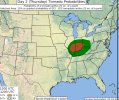
View attachment 50649
Kds86z
Member
Kds86z
Member
Kds86z
Member
Kds86z
Member
WaryWarren
Member
Kds86z
Member
CheeselandSkies
Member
If it weren't for that pesky warming aloft, it'd be a nice setup. Normally the winter setups that produce are the ones that have cold air aloft overspreading the surface moistening, and normally that's not so hard to get seeing as it's, you know, winter, but that seems to have been a recurring them recently. Hope that doesn't continue into the spring.
CheeselandSkies
Member
Woke up to the sound of thunder and rain on the window. Smells like spring outside. ")
- Thread starter
- #37
WeathermanLeprechaun
Member
If I'm being honest, tomorrow does feature potential for significant tornadoes in S IL moving east into SW IN. The question is will warming aloft dismantle any supercell that attempts to go up? I have questions but moisture should be enough past 4pm to fire storms and then can they reach their EL? Also note the surface inversion. Cells will need a way to go surface based.
(i have a AWFUL lot of weather related tabs open LOL)
(i have a AWFUL lot of weather related tabs open LOL)
Attachments
Ozonelayer
Member
Can't say I disagree much. Though I'd say I'm a little more bullish.If I'm being honest, tomorrow does feature potential for significant tornadoes in S IL moving east into SW IN. The question is will warming aloft dismantle any supercell that attempts to go up? I have questions but moisture should be enough past 4pm to fire storms and then can they reach their EL? Also note the surface inversion. Cells will need a way to go surface based.
(i have a AWFUL lot of weather related tabs open LOL)
Maybe a little later after 4 PM the surface inversion should weaken enough to promote a one to even a few sigtors through that corridor as storms go surface based? The inversion doesn't look particularly strong by any means.
- Thread starter
- #39
WeathermanLeprechaun
Member
But it comes down to the warming aloft as well. It's not a guarantee storms sustain. It's pretty conditional but it's there.Can't say I disagree much. Though I'd say I'm a little more bullish.
Maybe a little later after 4 PM the surface inversion should weaken enough to promote a one to even a few sigtors through that corridor as storms go surface based? The inversion doesn't look particularly strong by any means.
Kds86z
Member
Isn’t it unusual to have warming aloft in Feb?But it comes down to the warming aloft as well. It's not a guarantee storms sustain. It's pretty conditional but it's there.