WeathermanLeprechaun
Member
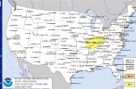
Outlined D4 15%
"Medium-range guidance indicates that a sub-1000 mb surface cyclone,
centered across the central Great Plains at the outset of the
period, may undergo a period of further deepening as it migrates
across and northeast of the lower Missouri Valley, toward the Great
Lakes, late Thursday afternoon or evening. Perhaps most notable,
latest model output appears a bit more aggressive than last night
concerning a corridor of warm sector moisture return into the
vicinity of the confluence of the Mississippi and Ohio Rivers. It
now appears that this may include surface dew points increasing as
high as the upper 50s to lower 60s F by around 20/00Z, which may
advect at least a bit further east-northeastward through the lower
Ohio Valley, before being cut off later Thursday evening. Though
still somewhat modest, and perhaps only supportive of CAPE on the
order of 500 J/kg, this probably will be conducive to severe
thunderstorm development, in the presence of more than sufficient
deep-layer shear and large-scale ascent to support organized
convection. This may include supercells with potential to produce
tornadoes, and perhaps an upscale growing cluster with strong to
severe gusts for a period Thursday evening"
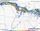