
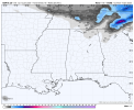
00z GFS just came in with more substantial snow Wensday. The northern half of Alabama with some measurable snow from a dusting to 2 inches
Navigation
Install the app
How to install the app on iOS
Follow along with the video below to see how to install our site as a web app on your home screen.
Note: This feature may not be available in some browsers.
More options
-
Welcome to TalkWeather! We see you lurking around TalkWeather! Take the extra step and join us today to view attachments, see less ads and maybe even join the discussion. CLICK TO JOIN TALKWEATHER
You are using an out of date browser. It may not display this or other websites correctly.
You should upgrade or use an alternative browser.
You should upgrade or use an alternative browser.
Winter Weather Season 2025-26
- Thread starter Atlantic
- Start date
-
- Tags
- winter weather
JasonL
Member
After moving from Ga to IL last April, I have seen enough white on the ground to last me for a while!
here is hoping for snow in the beloved South!!!
here is hoping for snow in the beloved South!!!

Atomz
Member
These past few GFS runs have been very consistent with snowfall in both N Al and GA; Euro has also started to pick up on this trend.Well hello there - Saturday night looks interesting, in addition to possible back-end flurries on Wenesday. Hoping this presentation holds, would love to see a little bit of powder, although down here it's usually just icy sludge.
View attachment 49886
It would be pretty nice to see some more white stuff around here; I think that last time we had any was actually around this same time last year.
akt1985
Member
The great thing about the possible snow next weekend is a lot of people will already be off of work and school.
sak
Member
seems like the Euro is backing off on the chances of accumulating snow in N AL. 24-36 hours ago, this was in the 40-50% range for the TN alley, and 20% plus for the I-20 corridor. now more like 25% for the TN valley, 10% for I-20 corridor.

- Thread starter
- #67
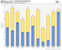
Looks like I’m in the 60% contour, being in Virginia.seems like the Euro is backing off on the chances of accumulating snow in N AL. 24-36 hours ago, this was in the 40-50% range for the TN alley, and 20% plus for the I-20 corridor. now more like 25% for the TN valley, 10% for I-20 corridor.
View attachment 49888
Kds86z
Member
Flurrying here this eveningGFS and euro on board with some light snow/ flurries in Alabama on Wednesday
Seems like the past few years, the Starkville area has either just not north enough or not been south enough to see snow. Certainly getting tired of 33° rain.
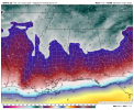
GFS isn't show much precip for Saturday that had been there. But you definitely can see the stream of moisture
Can somebody wishcast snow into existence in Alabama please? Lol
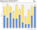
12z GFS showing almost 2 inches for Birmingham
Atomz
Member
What about for Atlanta? I'm at school and I haven't been able to check.12z GFS showing almost 2 inches for Birmingham
Around 1 and half like Birmingham. Im hoping by Wensday there will be consistency between both the Euro and GFS for at least a dusting here in the southWhat about for Atlanta? I'm at school and I haven't been able to check.
Temperature differences between the NAM, EURO, GFS at 06z Friday.


12z Canadian would feature the coldest temperatures for North MS without snow on the ground for January since 2018.
This happened the morning of January 17th, 2018. Yes, that is a patch of frost on the inside of my front door!
This happened the morning of January 17th, 2018. Yes, that is a patch of frost on the inside of my front door!
Attachments
Feels like the models are struggling some with the moisture, atleast for Wensday night into Thursday morning from my observation
Cyclonic Paracosm
Member
long range gfs has been hinting at a p big snow event near the 25th but 18z gfs is um, mental 1000% not occurring but snow equiv of a death run
With all the expected cold coming up this weekend into the next couple weeks, can't wait to be put under the deadly Cold Weather Advisory again..... LOL!
Should have kept Wind Chill Advisory and just do Extreme Cold Warnings/Watches. You can't tell me Cold Weather Advisory makes people react differently then saying Wind Chill Advisory.With all the expected cold coming up this weekend into the next couple weeks, can't wait to be put under the deadly Cold Weather Advisory again..... LOL!